Author Archives: Roger Farnworth

Unknown's avatar

About Roger Farnworth

A retired Civil Engineer and Priest

Through Norway by Rail – The Railway Magazine, November 1899

E.E. Speight tells of his own experiences travelling by rail in Norway. In an article which is primarily a travelogue rather than a technical piece. He fails to mention the gauges of the different railways that he travels along. [1] The matter of the differing gauges of railways in Norway is covered in some paragraphs below.

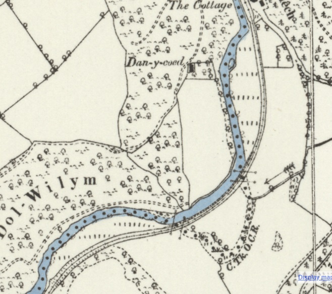
In 1899, Norway had around 1,300 miles of railway. The principal elements were lines running:

  • from Christiania South towards Sweden reaching the border at Kornsjo (169 km – the Smaalensbanen);
  • from Christiania East towards Sweden reaching the border beyond Kongsvinger;
  • from Christiania to Trondhjem (562 km) with branches to Lillehamer, Otta and from Elverum to Kongsvinger;
  • from Trondhjem to Storlien (108 km) to meet the line in Sweden from Stockholm;
  • from Christiania South to Drammen, Laurvik and Skien (204 km) with branches to Randsfjord, Kongsberg and Kroderen, Horten and Brevik.
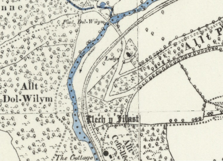
  • between Christiansand and Byglandsfjord (Saetersdal); Stavanger and Ekersund (Jaederbanen); and Bergen to Vosse (108 km).

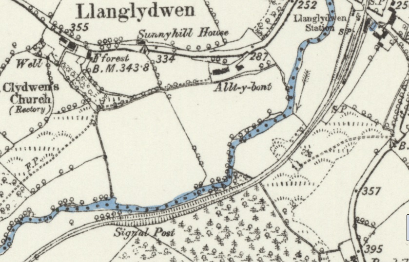
The city of Oslo was founded in 1024. In 1624, it was renamed Christiania after the Danish king; in 1877, the spelling was altered to Kristiania. In 1925, it reverted to its original medieval name of Oslo.

It seems as though E.E. Speight may have missed the 1877 memo about the renaming of the city, and so continued to refer to Kristiania as Christiania. Reading in the 21st century we need to read Christiania as Oslo.

In the 21st century, the Norwegian railway system comprises 4,109 km of 1,435 mm (4 ft 8 1⁄2 in) (standard gauge) track of which 2,644 km is electrified and 274 km double track. There are 697 tunnels and 2,760 bridges. [2]

This was not the case in the early years of the network. The first railway in Norway was the Hoved Line between Oslo and Eidsvoll and opened in 1854. The main purpose of that railway was to move lumber from Mjøsa to the capital, but passenger service was also offered. In the period between the 1860s and the 1880s Norway saw a boom of smaller railways being built, including isolated railways in Central and Western Norway. The predominant gauge at the time was 1,067 mm (3 ft 6 in) (narrow gauge), but some lines were built in 1,435 mm (4 ft 8 1⁄2 in) (standard-gauge), particularly where those lines connected to the standard-gauge lines of Sweden. [2]

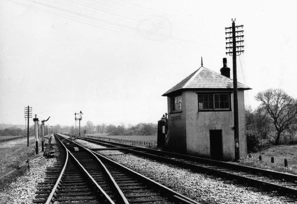
When building the Norwegian Trunk Railway (1850-1854), Robert Stephenson built the line to British standard gauge. This line was very expensive; Pihl argued that narrow-gauge railways would be less expensive to construct, he argued successfully for 3 ft 6 in (1,067 mm) gauge. During the railway construction boom of the 1870s and 1880s all but the Kongsvinger Line, the Meråker Line and the Østfold Line were built with narrow gauge, leaving Norway with two incompatible systems. [7]

The 3ft 6in gauge was chosen by Carl Pihl in 1857 as the ‘standard-gauge’ for Norwegian railways. Pihl was a civil engineer and director of the Norwegian State Railways (NSB) from 1865 until his death in 1897. [7]

A number of main line railways were built to the 3 ft 6 in (1,067 mm), to save cost in a sparsely populated mountainous country. This included: the Hamar – Grundset Railway which commenced operation in 1861; the more challenging Trondheim – Støren Railway which commenced operations in 1864; and Norway’s first truly long-distance line, the Røros Line, connecting Oslo and Trondheim (in 1877).

In 1883 the entire main railway network had been taken over by Norwegian State Railways (NSB), though a number of industrial railways and branch lines continued to be operated by private companies. [2]

It was the decision of the Norwegian Parliament to construct the Bergen line to standard-gauge (in the year following Phil’s death), which finally settled the debate over gauges. By this time, it had been demonstrated that standard-gauge lines built to the same specifications as the narrow gauge could be constructed at the same cost. [7]

Ultimately, all narrow-gauge lines owned by the NSB  were either closed or converted between 1909 and 1949, at a cost many times larger than the initial savings of building them narrow.

Projects such as the Bergen Line and the Sørland Line (also built to standard-gauge) were connecting all the isolated railways and transshipment costs were becoming significant. [7]

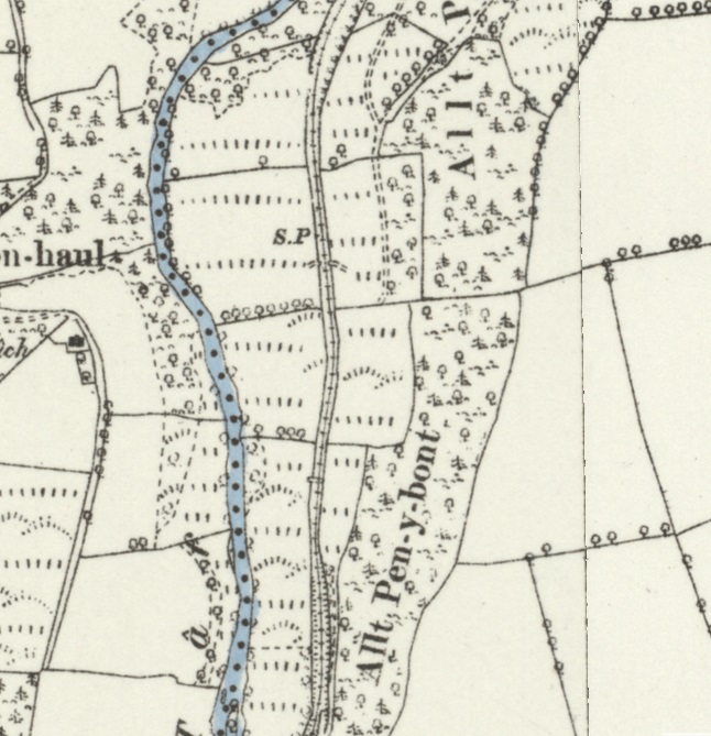
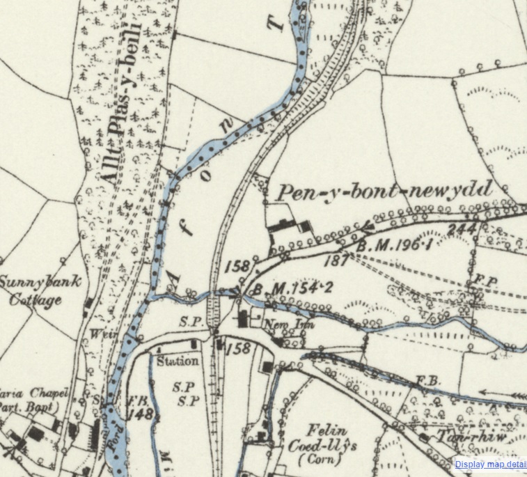
Some private railways had 750 mm (2 ft 5 1⁄2 in) and one had 1,000 mm (3 ft 3 3⁄8 in) gauge. A few railways are in part still operated as museum railways, specifically the Thamshavn Line, Urskog–Høland Line and the Setesdal Line. [3]

The Thamshavn Line (Norwegian: Thamshavnbanen) was Norway’s first electric railway, running from 1908 to 1974 in what is now Trøndelag county. Today it is operated as a heritage railway and is the world’s oldest railway running on its original alternating current electrification scheme, using 6.6 kV 25 Hz AC. It was built to transport pyrites from the mines at Løkken Verk to the port at Thamshavn, as well as passengers. There were six stations: Thamshavn, Orkanger, Bårdshaug, Fannrem, Solbusøy and Svorkmo. The tracks were extended to Løkken Verk in 1910. [4]

The Urskog–Høland Line (Norwegian: Urskog–Hølandsbanen), also known as Tertitten, is a narrow gauge (750 mm (2 ft 5 1⁄2 in)) railway between Sørumsand and Skulerud in Norway. [5]

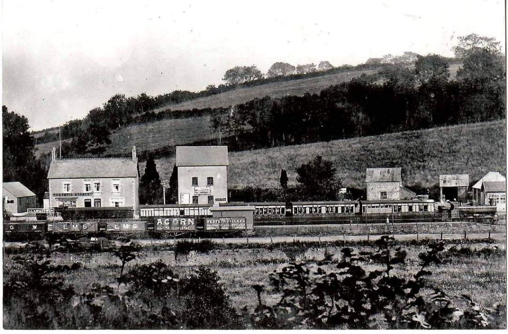
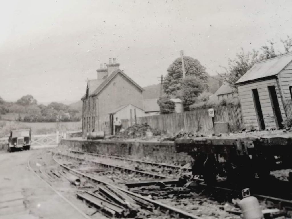
The Setesdal Line (Norwegian: Setesdalsbanen) was a railway between Kristiansand and Byglandsfjord in southern Norway, 78 km (48 mi) long. It was built with a narrow gauge of 1,067 mm (3 ft 6 in), and opened to Hægeland 26 November 1895, and to Byglandsfjord 27 November 1896. Stations along the line included Mosby, Vennesla, Grovene (Grovane), Iveland and Hægeland. Now, 8km of this line is open as a heritage railway. [6]

By the 21st century, of the operational (non-heritage) railways in Norway, only the Trondheim (Trondhjem) Tramway has a different gauge, the metre-gauge, 1,000 mm (3 ft 3 3⁄8 in). [2]

Returning to Speight’s article in The Railway Magazine, he refers his readers to a government publication in French and Norwegian which provided excellent statistical information and maps/plans – De Offentlige Jernbaner, Aschehoug & Co., Christiania. This appears to have been a regular, annual, publication and copies from later years can be purchased online. [8]

Speight focus was on describing his own experiences on the rail network in Norway. He entered Norway from Sweden on a train which ran direct from Helsingborg (in Sweden) to Christiania (Oslo) remarking on the spaciousness and comfort of the Norsk-Svensk hurtugtog, or fast train.

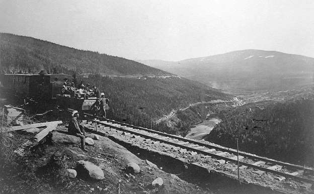
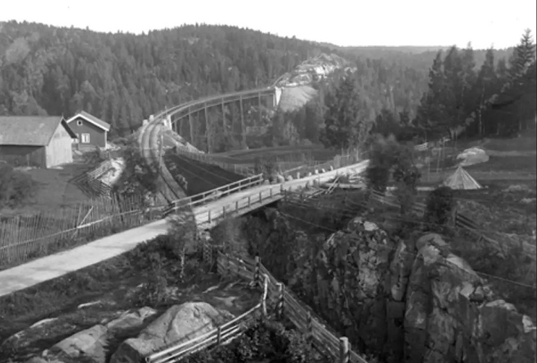
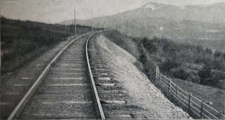
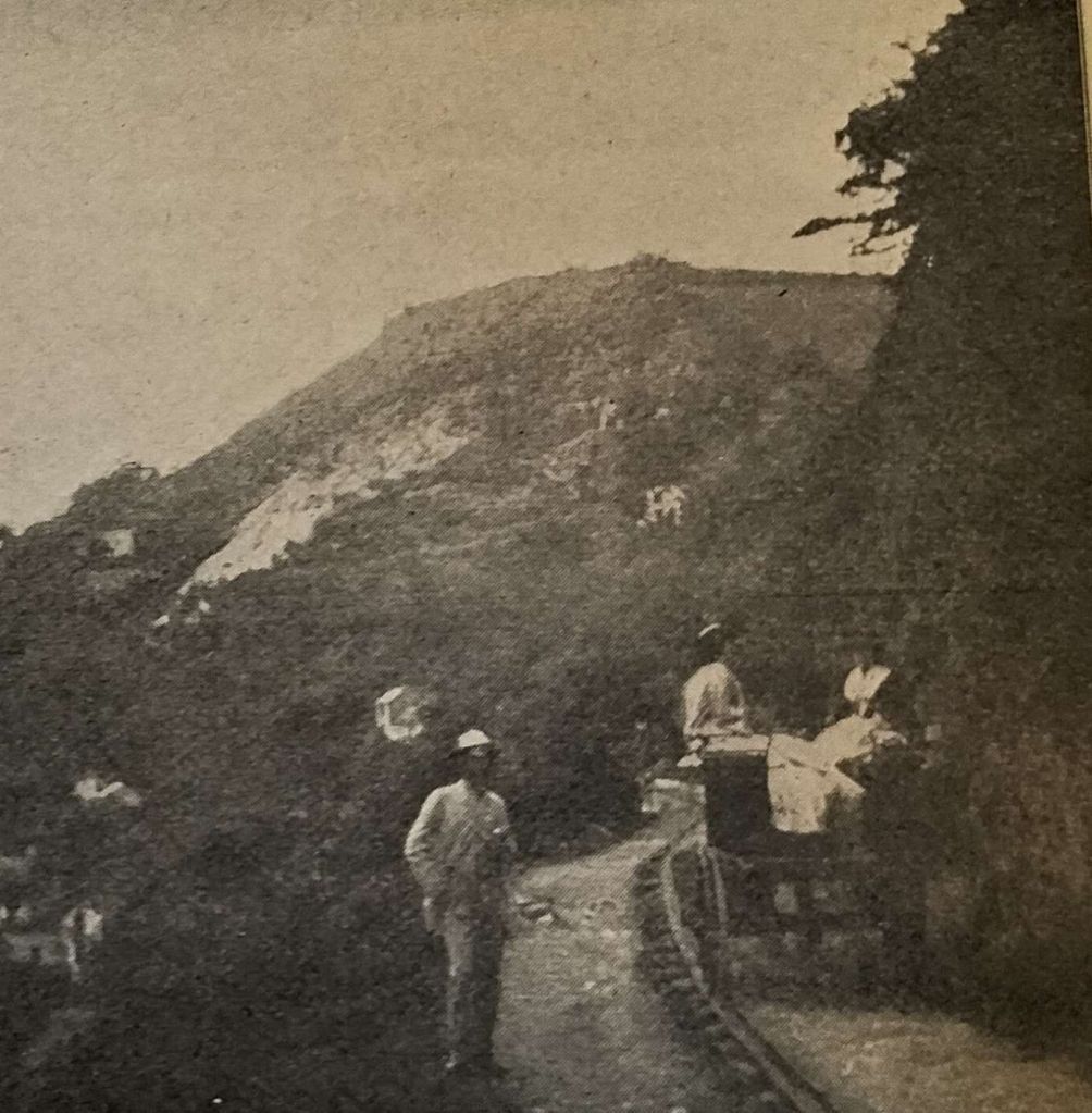
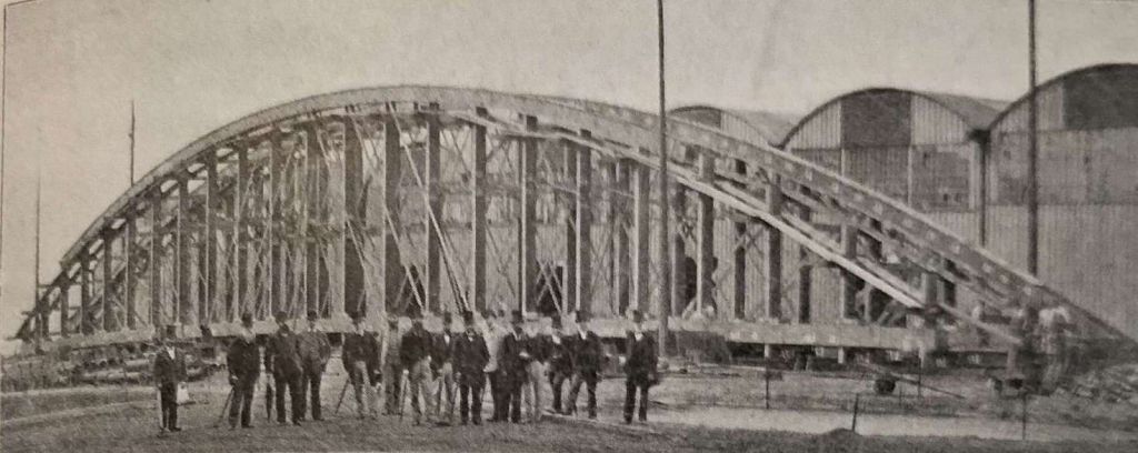
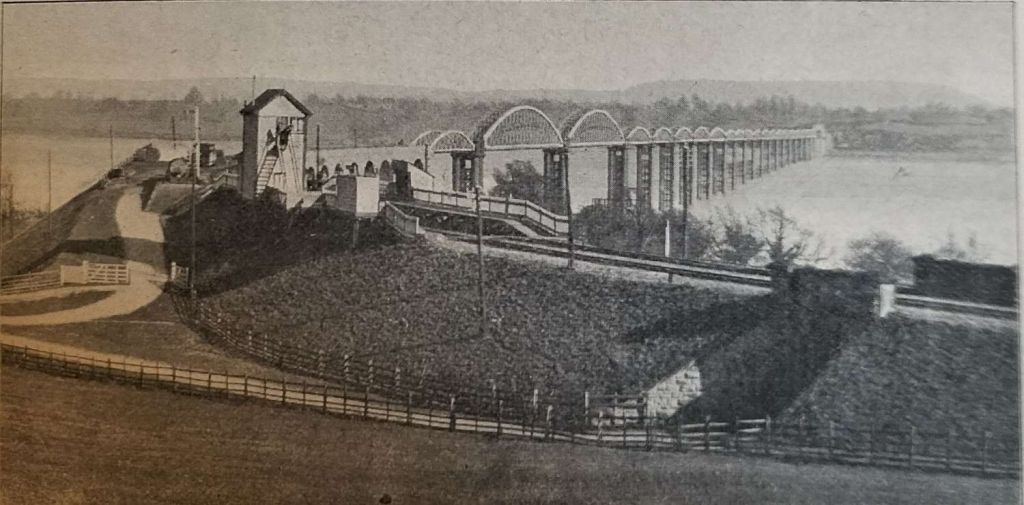
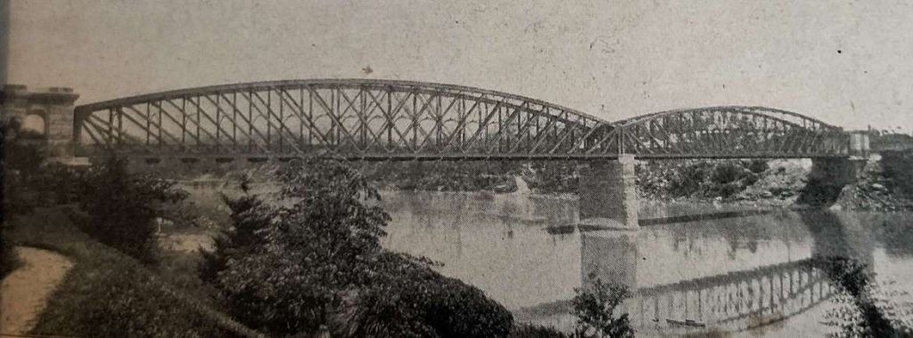
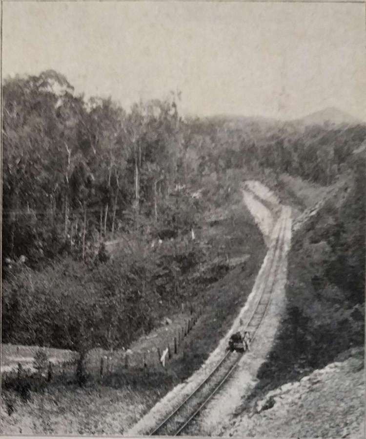
His first sight when opening the curtains of his train compartment in the morning was drizzle at the station in Frederikstadt. His first rail with rail journey in Norway was travelled at a very slow pace with long waits at stations in the route to Christiania (Oslo). He comments on the dramatic scenery and on the difficulties which must have been experienced in building the line on which he was travelling. Speight points his readers to the illustration below, which shows the Ljans viaduct (admittedly the photo quality is poor) and he says: “The train winds in and out among rocks and trees and over many a gorge, passing the most picturesque little  wooden homesteads all the way from Ljan, a few miles out of the city. One of the pretty villas was a smoking ruin as we passed, and the conductor told me that the day before it was all right, and that such fires were a common occurrence. At the upper window of another of these wooden villas, standing just over the water of an inlet of the fjord, appeared two faces, and the conductor cheerily saluted his wife and little child, as he does three times each week on his return from Sweden.” [1: p449]

Ljans Viaduct near Christiania (Oslo). Sadly, the picture included in the Railway Magazine is too grainy, [1: p448] This image was found on an internet form and appears to be the same image that was used in The Railway Magazine, © Olaf Peder Martin. It is held in the collection of the Norsk Jernbarnemuseum. The Ljans viaduct was completed in 1878. The bridge was sold to Christiania Spigerverk after the line got re-aligned towards Hauketo in 1925. It was blown up to provide materials for nails in 1929. [9]

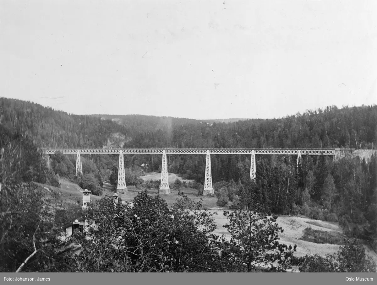
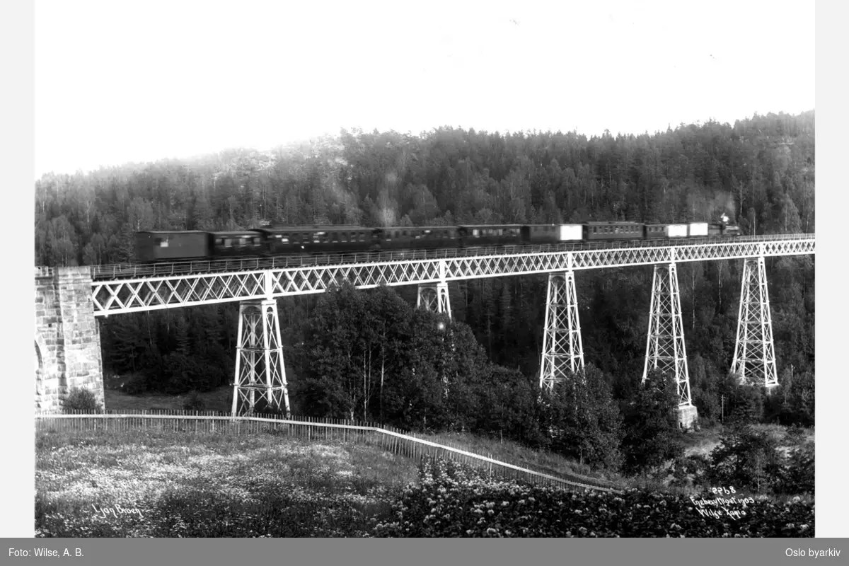
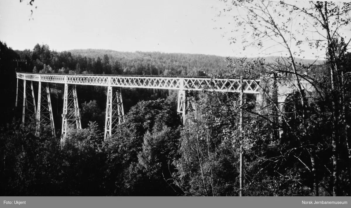
The three photographs immediately above are further photos of Ljans Viaduct taken before 1929 all of which are in the collection of the Norsk Jernbarnemuseum. [9]

Speight continues: the main station in Oslo “adjoins the quays, and is at the bottom of the main street which runs up past the chief shops to the Castle, Carl Johan’s Gade, or Johan as it is known all over Norway.” [1: p449]

The trip from Copenhagen to Christiania (Oslo) was advertised as an 18 hour or a 22 hour journey. In Speight’s view, the journey could have been completed in either 12 or 14 hours. The causes for the length of the journey, in Speight’s view were “the length and weight of the trains, the frequent long stops and the form of locomotive used. … They [were] manifestly incapable of taking the eight or ten corridor carriages over the gradients on this line. … The [then] present total of stopping time amount[ed] to about three hours; this [was] partly accounted for by the fact that meals [were] taken in the stations, and at the customs station a long stay [was] made. But there [was] no need for the five or ten minutes’ stops made at many of the small stations where the little business could [have been done]  in a quarter of the time. If the two Governments cared to run … an express, from Helsingborg, stopping only, say, at Halmstad, Gothenburg, Trollhättan, Frederikshald, Frederik stadt and Moss (running a steamer thence to Horten for quick connection with Skein and Drammen) the journey  should [have been completed] in 12 hours, the more easily if a restaurant car were [to be] attached to save long stops.” [1: p450]

Speight then travelled Southwest from Oslo along the line which had termini in Skein, Kroderen and Kongsberg. He complains that no first class carriages were provided on the line and comments again about the slow speed of the service despite expresses being provided. He says: “An approach is made towards running expresses, four trains daily passing between Christiania and Drammen, 33 miles, without a stop, but with an occasional crawl, in an hour and a half. There are obstacles to fast speed on this line also, as there are many crossings and such gradients that for the heavy trains it is necessary to have a small engine at each end The point of depar ture in Christiania is situated by Piperviken, a quay for coast steamers. Vestbanens station is smaller than the Eastern station, but none the less cold and uncomfortable. There is no refreshment room, and some of the less known Midland stations, say Bingley or Keighley, are palaces in comparison. The trains, however, are comfortable, being provided with through passages, open to the public, and irregularly disposed seats – some like an English tram car, others saloon fashion.” [1: p450]

Speight has only praise for the scenery on the line: “The scenery along the line is remarkably attractive. Inland, after leaving the western bights of Christiania fjord, the road is cut through many pretty bits of English scenery, and at busy, timber-laden Drammen the sea again appears. It is near Holmestrand, however, that a typical form of Norwegian railway is traversed, where high speed is manifestly impossible. On one side are cliffs, pine-clad and bird-haunted; on the other, beating against a low sea-wall, the water of the fjord. Holmestrand is a little seaside resort which is becoming very popular. The railway here runs close under the cliffs, and the town spreads on the narrow steep between the line and the beach. Down to Tönsberg, a viking town of lost glory, the train is backed, to be run out after a short stay on to the main line again, a proceeding which would have been unnecessary had the station been built some half-mile from the present one. The district between Tönsberg and Laurvik is meadow and shrubby rockland, abounding in ancient memories of rich plundering days. In one field near the railway is the famous Gokstad mound, whence, some years back, the large viking ship was taken which now stands in the University Museum at Christiania.” [1: p451]

At Sandefjord, one of the most prettily situated towns in Norway, at the head of a four-mile fjord, with wooded rocky banks, [were] many signs of prosperity, and goods wagons are constantly to be seen in the sidings and down at the harbour, to which a branch line runs through the town. From here the line goes over the crest of the hill to Laurvik, a growing port, where passengers from Christiania for English ports are taken on board. Though the distance from Christiania is only 98 miles, the quickest train, the 11.17 p.m., takes 4 hr. 40 min. to make the journey, and one wretched “blandet-tog,” or mixed goods and passenger, actually spends 10 hr. 40 min. on the way. There is a morning train from Laurvik to Christiania which takes 11 hours, being passed on the way by another. Those who are unfortunate enough to be reduced to riding in one of these mixed trains have a dreadful time.” [1: p451]

This line, after leaving Laurvik, passes through Porsgrund, famous for its porcelain, and ends at Skien, a thriving manufacturing town.

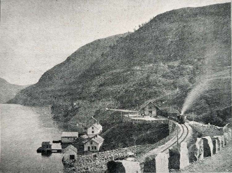
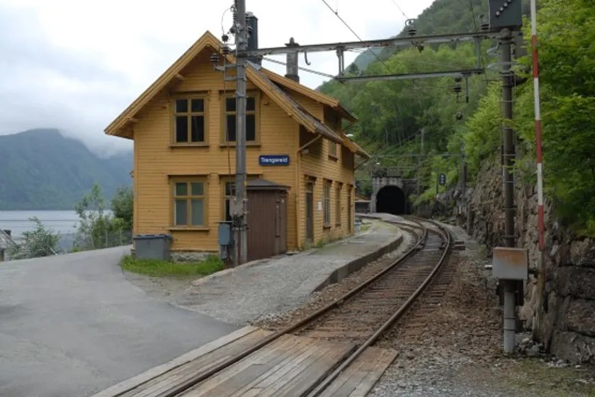
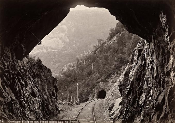
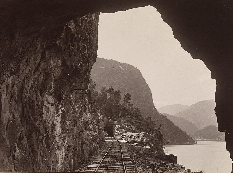
Speight was unable to travel over the lines which run from the coast inland, those from Christiansand to Byglandsfjord, Stavanger to Ekersund, and Bergen to Voss. He comments that the “two latter are perhaps too well known to English tourists to need description. … Two of the views accompanying this article (Trangereid Station and the mountain tunnel between Dale and Bolstad) will remind visitors to Bergen of the marvellous manner in which the engineering difficulties along the Vossebanen have been overcome.” [1: p451]

Trengereid Station on the Bergen-Vosse railway. [1: p449]
Trengereid Station on the Bergen-Vosse railway in the 21st century. Some remodelling of the station building has taken place, © Njal Svingheim. [10]
A tunnel (Fjeldport med Tunnel) on the Bergen-Vosse Railway (the Vossebanen) between Dale and Bolstad. Sadly, the image in The Railway Magazine is grainy and a little blurred. [1: p447] This is the same image found online. The Vossebanen is oldest part of the Bergen line. The line was started in 1875 and opened in 1883. The stretch was originally 106.7 km long, with 52 tunnels and 15 stops. After several line changes, the Vossebanen is today 86 km. The original stations of the track were designed by Balthazar Lange. Vossebanen is urban but also scenic. There is quite a lot of passenger trains but also a lot of freight traffic on the line. [11]
This photograph is taken at approximately the same location as the one immediately above and also shows the Fjeldport med Tunnel, © Mo i Rana, Public Domain. [12] Photographs of other tunnels in the area can be found here. [13]

Speight now turns from the smaller lines in Norway to what was known as the trunk line to the North, “a line which by the very nature of the country it passes through must always attract the attention of those who are “railway mad.” Its seclusion and remoteness from the general tourist-route, added to the fact that from the map it appears to traverse a most romantic part of the country, stealing through the mountains, like the Midland line from Settle to the North, lends an air of mystery.” [1: p451-452]

From Oslo (Christiania), the train leaves “the large station by the docks at 1.45pm and runs to Eidsvold and over an inlet of Lake Mjosen into Hamar (on that section of the line built originally by an English company, and called Hovedbanen) steadily at 26 miles per hour, through meadow, wood, and lakeside scenery. At Hamar a change of trains is  made, and all the passengers rush into the refreshment-room for ‘mid-dag’, an abundant meal of three courses, which costs about two shillings. Ample warning is given, and then you take places in a most comfortable corridor-train which seats and sleeps two persons only in each first-class compartment, a convenience which makes the journey no hardship, and which is regulated from the booking-office in Christiania. After leaving Hamar the pace is slow but very steady, and one’s attention is wholly occupied by the view from the windows. Fairly level country is passed through until Elverum, twenty miles from Hamar, then begins a slow climb, which lasts for eight hours. Elverum is 608 feet above the sea, and Tyvold, the highest point on the line, which is passed about two in the morning, 2,158 feet.” [1: p453]

Tonset (Tynset) Railway Station, 1,520ft above sea-level. [1: p450]
An old postcard view of Tynset Railway Station from 1924, © Carl Normann, Public Domain. [14]
Tynset Railway Station in the 21st century. [15]

The line climbs alongside the River Glomen for 150 miles, alternately on one bank then the other, until “settling down to a regular position east of the stream, under steep wooded cliffs. The river was filled with timber floating down from the mountains. … Across the valley which grew narrower hourly were mountain-ridges, whose summits were white with snow. Under them nestled farms the whole way, though their share of sunlight and warmth seemed to be small. Here and there would appear clusters of prosperous looking farmsteads, with telephone lines running from one to another. And all the while the long train was slowly making its way up through cuttings and tiny rock tunnels, along sandy strips of road among the fragrant pines.” [1: p453-454]

A tunnel and embankment on the railway, near Koppang. This gives a good idea of the valley at one of its wider parts.
Koppang Railway Station in the early 20th century, © Hamar Thjems, Public Domain. [16]
Kappang Railway Station in the 21st century. [17]

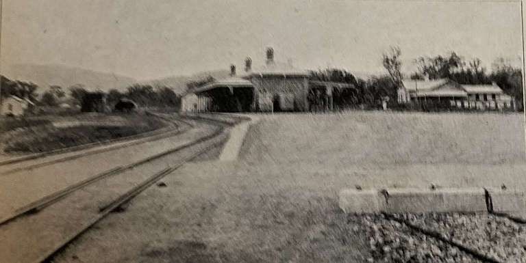
Speight continues: “Koppang was the supper-place, where we had twelve minutes to drink milk and eat smörbröd, i.e., sandwiches of bread and fish, cheese, or meat. After leaving this station the conductor began to prepare the beds, and when they were ready they were indeed cosy. Sleep came easily after the mountain air, and although the intervening grades of the slope were missed, this only heightened the surprise with which I looked out of the window after suddenly waking at two o’clock. The scenery had changed entirely. We were running along the side of a bare, wintry ridge, and the next minute passed gingerly over a roaring torrent. It was light, as the June nights are in Norway, and … everything was covered with snow, altogether such a view as one might get among the upper heights of Craven in winter. I had missed Röros, the high mining town, which I specially had hoped to see, but it was gratifying to have returned to consciousness just at the very highest point of the line.” [1: p454]

Stören Railway Station, near Trondhjem. [1: p453]
Stören Railway Station in the 21st century © Beagle84 and used here under a Creative Commons Licence (CC BY-SA 3.0). [18]

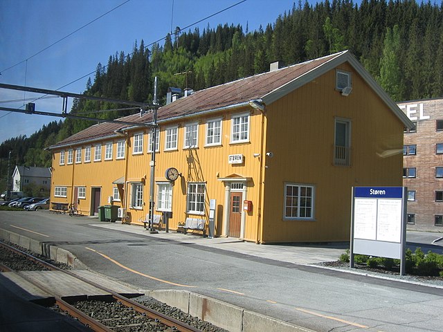
It took five hours to drop 2,100ft to sea-level at Trondhjem, “here everything was cold and desolate, and all the barns were dripping. … At Stören, reached [at] about five, the conductor brought us coffee and biscuits from the refreshment room. … From Stören we ran the 33 miles into Trondhjem in an hour and a half … and at 6.55 am, the train drew up alongside the harbour, where in old days the Hansa ships docked.” [1: p454-455]

The line beyond Trondhjem … runs over the mountains into Sweden, … it provides one of the most fascinating railway journeys possible. … From Trondhjem the line runs along the bends of the fjord for many miles, turning finally inland at a place called Hell. …  Then we enter Stördal, a narrow valley much resembling Upper Wharfdale, but with higher fells on each side and steeper falls of water coming down through the trees. For thirty miles the train creeps along into the heart of the mountains, past isolated farms, and always near the river, for the valley is only a few yards wide in places. The cart-road is grass-grown and one can see that the railroad is responsible for most of the traffic. Time after time one seems to be running straight into the hills; then a bend is turned and another mile or so of valley appears, with wonderful variety of forest and mountain views.” [1: p455]

When the train arrived at Gudaan a locomotive was attached behind, and then the train was pushed and pulled up through the otherwise bleak and desolate forest. Speight continues: “So well do we climb that in one hour we have actually ascended 1,000 feet, and when we reach the Swedish frontier station, [Storlien], sixty-six miles from Trondhjem, we are over 2,000 feet above the sea, in a wilderness of deep snow, though it is already June.” [1: p455]

A severe climb on the railway towards Storlien. [1: p454]
Storlien Railway Station in its early years – 1880, © Public Domain. [19]

This laborious journey between Norway and Sweden was necessary because there was constant traffic between Sweden and Trondhjem and trains can be very heavy. Speight refers us to Samuel Laing, who, he says, “lived in this region about the year 1834, [and] dwells at some length on the trade route over into Sweden, traversed in winter by sleighs, the best railroad in the world, he says. His astonishment would have been worth recording had he been told that in time an actual railroad would penetrate these wilds of the Keel, and that comfortable, spacious carriages would daily find their way through those bleak woods.” [1: p455]

At Storlien, Speight, left Norway, continuing his journey into Sweden.

Early Locomotives in Norway

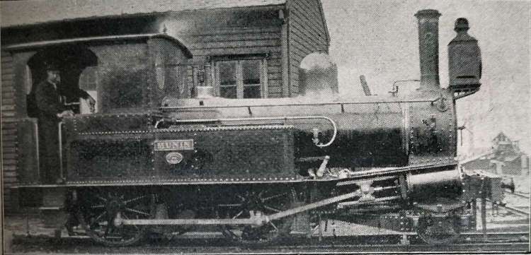
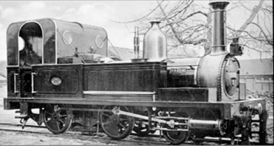
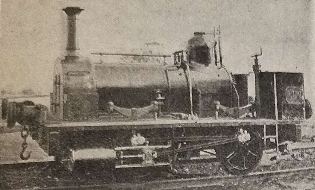
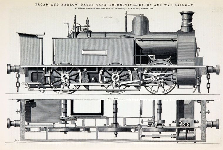
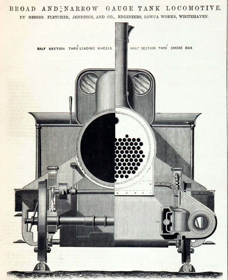
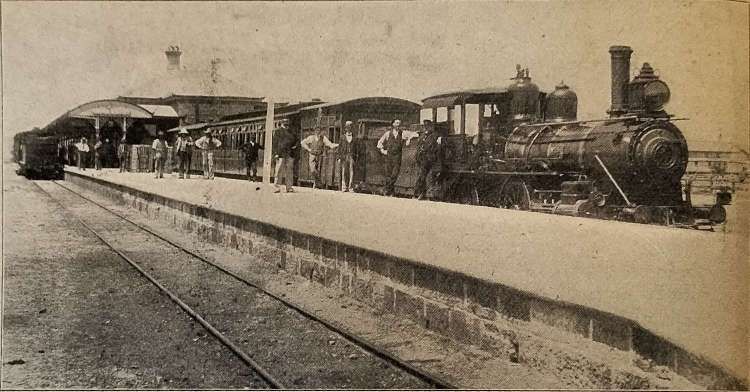
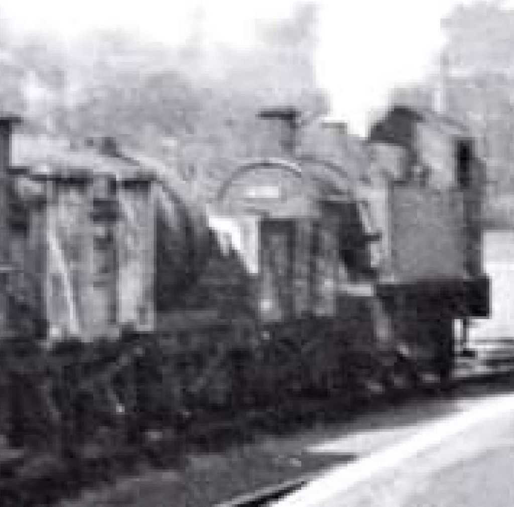
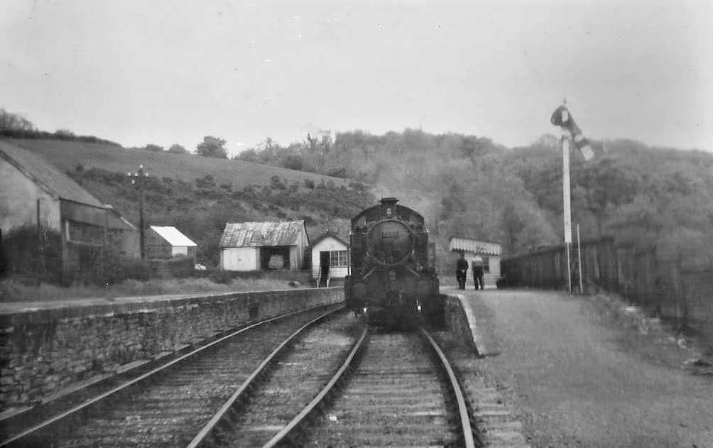
Speight commented on locomotives in Norway in 1899 seemingly being underpowered for the duties expected of them. He only provided one photograph of a locomotive in the article which is shown below. No details of the locomotive appears in his article. …

An 2-4-0T Norwegian Locomotive! Speight provides no details about the loco. It appears that it carries the name Munis. [1: p451]

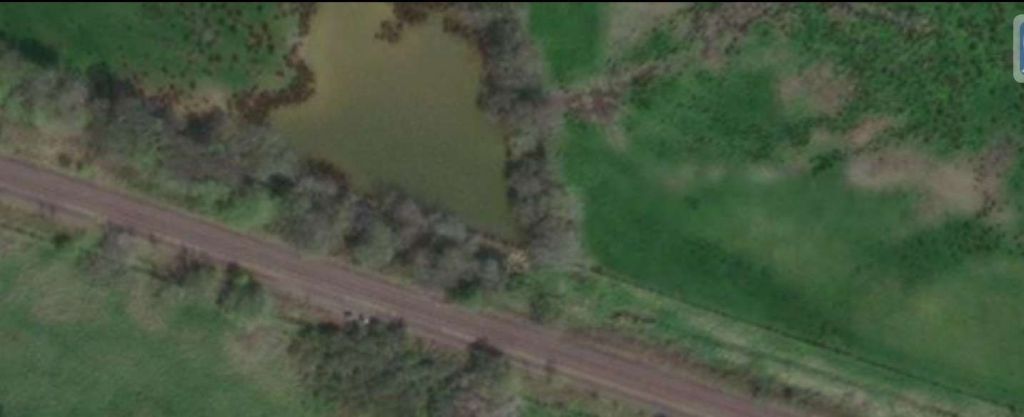
It seems as though Norway’s early narrow gauge steam locomotive classes were numbered using roman numerals by the NSB (I,II,III,IV,V, etc). [20] There is a limited amount of information available online about these locomotives, but it seems that a lot of the earliest classes were 2-4-0T locos. However, the first 3ft 6in gauge steam locomotive on Norway’s railways was an 0-4-2T, not a 2-4-0T but of a similar size to the other tank locomotives pictured above and further below. This 2-4-0T locomotive was No. 1 of the Hamar – Grundset Railway and is shown below at Løten station. The date was 18th October 1861, and it is believed that the photo was taken during a test run. Regular timetabled operations commenced on the railway the following month. The locomotive was built by Robert Stephenson & Co. in 1860. I found the photograph on transpressnz.blogspot.com. [25]

No. 1 of the Hamar – Grundset Railway shown at Løten station on 18th October 1861. It is believed that the photo was taken during a test run. [25]

I have not been able to clarify which class of locomotive is pictures in E.E. Speight’s article. Similar sized locos are pictured below but all different in some way from E.E. Speight’s photograph – different cab, different dome, different chimney.

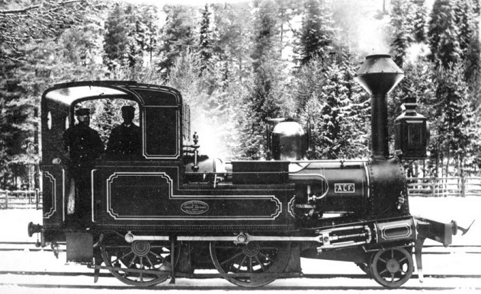
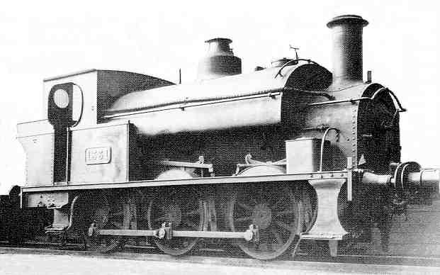
An example of the NSB Class II 2-4-0T side tank locos is shown below.

NSB Class II 2-4-0T Loco No. 3 Hakon. [24]

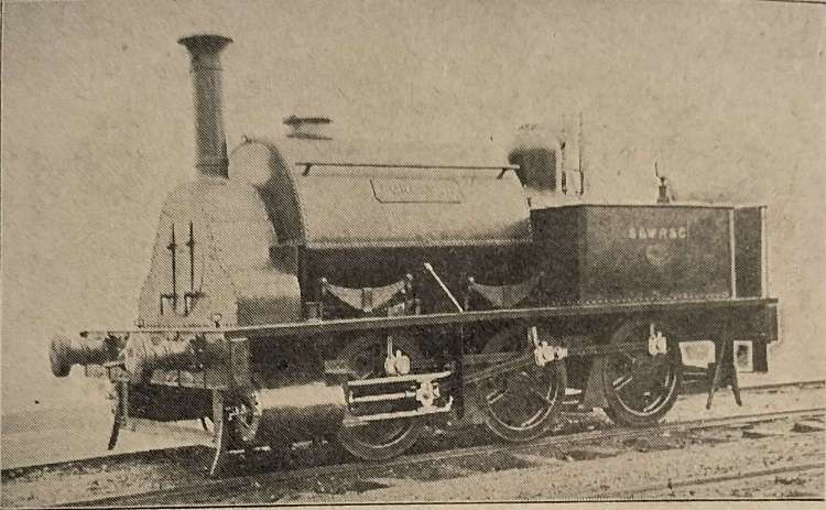
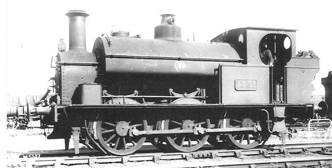
The NSB Class III locos were a class of six side tank 2-4-0T locomotives. They were built by Beyer, Peacock and company from 1868 to 1871 as part of the III class for the Norwegian State Railways. They were designed, built and operated for small local passenger trains for which they operated until the 1920s.

NCB Class III 2-4-0T Loco. No. 21, Alf. [22]

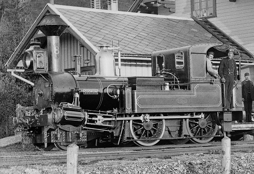
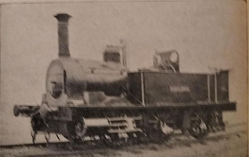
The NSB Class IV (or Tryggve Class) locos were 1,067 mm (3 ft 6 in) narrow gauge 2-4-0T steam locomotives built by Beyer, Peacock & Co. in Manchester, England. [21] This was a class of twenty-five side tank 2-4-0 locomotives. The first of the class was built by Beyer, Peacock and company in 1866 and the last built in 1882 also by Beyer, Peacock and company and originally classed II and XV from 1898. In 1900 the class was re-designated IV and IX and operated by the Norwegian State Railways until 1952 when the last one was withdrawn. The class was named Tryggve after the first locomotive of the class which was also numbered two. [23]

NCB Class IV 2-4-0T Loco No. 8, Cudrun at Melhus station. [23]

All these locomotives could well have been encountered by Speight on his journey through Norway.

References

  1. E.E. Speight; Through Norway by Rail; in The Railway Magazine, London, November 1899, p447-455.
  2. https://en.m.wikipedia.org/wiki/Rail_transport_in_Norway, accessed on 11th September 2024.
  3. https://en.m.wikipedia.org/wiki/Narrow-gauge_railways_in_Norway, accessed on 11th September 2024.
  4. https://en.m.wikipedia.org/wiki/Thamshavn_Line, accessed on 11th September 2024.
  5. https://en.m.wikipedia.org/wiki/Urskog%E2%80%93H%C3%B8land_Line, accessed on 11th September 2024.
  6. https://en.m.wikipedia.org/wiki/Setesdal_Line, accessed on 11th September 2024.
  7. https://en.m.wikipedia.org/wiki/Carl_Abraham_Pihl, accessed on 11th September 2024.
  8. For example: De Offentlige Jernbaner: Driftsberetning For Norsk Hoved-jernbane … https://amzn.eu/d/5nfTiC5; and https://www.yumpu.com/no/document/read/19751486/de-offentlige-jernbaner-beretning-om-de-norske-jernbaners-drift-1-, accessed on 12th September 2024.
  9. https://www.skyscrapercity.com/threads/norway-railways.935718/page-9, accessed on 12th September 2024.
  10. https://www.banenor.no/en/traffic-and-travel/railway-stations/-t-/trengereid, accessed on 12th September 2024.
  11. https://www.amazon.co.uk/POSTER-Vossebanen-Fjeldport-Bolstad-replica/dp/B00P5I624K, accessed on 12th September 2024.
  12. https://no.m.wikipedia.org/wiki/Fil:528._Vossebanen,_fjeldport_med_Tunnel_mellem_Dale_og_Bolstad_-_no-nb_digifoto_20151106_00106_bldsa_AL0528_(cropped).jpg, accessed on 12th September 2024.
  13. https://jenikirbyhistory.getarchive.net/topics/rail+tunnels+in+vestland/historical+images+of+vaksdal, accessed on 12th September 2024.
  14. https://en.wikipedia.org/wiki/Tynset_%28novel%29#/media/File:7040_Tynset_Station_-_no-nb_digifoto_20150807_00223_bldsa_PK29688.jpg, accessed on 12th September 2024.
  15. https://help.g2rail.com/stations/tynset, accessed on 12th September 2024.
  16. https://upload.wikimedia.org/wikipedia/commons/thumb/7/7c/Koppang_stasjon.jpeg/1280px-Koppang_stasjon.jpeg, accessed on 12th September 2024.
  17. https://www.banenor.no/en/traffic-and-travel/railway-stations/-k-/koppang, accessed on 12th September 2024.
  18. https://commons.wikimedia.org/wiki/File:Storen_stasjon_Rorosbanen_2008.JPG, accessed on 12th September 2024.
  19. https://jenikirbyhistory.getarchive.net/media/storlien-station-3b47b4, accessed on 12th September 2024.
  20. https://en.wikipedia.org/wiki/Norwegian_State_Railways_rolling_stock, accessed on 12th September 2024.
  21. https://en.wikipedia.org/wiki/NSB_Class_IV, accessed on 12th September 2024.
  22. https://locomotive.fandom.com/wiki/NSB_Class_III, accessed on 12th September 2024.
  23. https://locomotive.fandom.com/wiki/NSR_IV_%22Tryggve%22_Class, accessed on 12th September 2024.
  24. https://digitaltmuseum.no/search/?aq=classification:%22RU%22,%225288%22, accessed on 12th September 2024.
  25. https://transpressnz.blogspot.com/2024/07/norwegian-0-4-2t-from-1860.html?m=1, accessed on 12th September 2024.

‘Arsenokoitai’ and ‘Malakoi’ in 1 Corinthians 6:9 and 1 Timothy 1:10

I first looked at these two words in a discussion of the place of ‘Sodom and Gomorrah in the Bible‘ [1] Their use in the two passages above has always provoked controversy. ….

Men Who Practice Homosexuality’

This phrase is used in two translations of the Bible, the ESV and the 2011 revision of the NIV. This ‘catch-all’ phrase in these two translations is not warranted by the individual Greek words used in these two contexts. The translation of these two words has always been a matter of uncertainty and debate and an accurate translation should have made it clear that it is not possible to define their meaning exactly.

The way the two Greek words are treated is a case of over simplification by the translators. In an endeavour to simplify a reading of the text, they have allowed their assumptions to narrow down meaning and perhaps even obfuscate what is true. The truth is that scholars either do not know, or cannot agree on the meaning of two Greek words, The two words are arsenokoitai (ἀρσενοκοίτης) and malakoi (μαλακοὶ). Their exact meanings are seemingly lost in the past and scholars have been debating the best translation of the words for some length of time.

The assumption that the translators of the ESV and the NIV make is that together they are a kind of ‘catch-all’ for all homosexual acts. This is just one opinion, it is not a justifiable assumption for translators to make.

Look at how historic translations of the Bible have translated ‘arsenokoitais‘: “bugger (1557), liers with mankind (1582), sodomites (1735), abusers of themselves with mankind (1885), those who abuse themselves with men (1890). The closest meaning of ‘arsenokoitai’ over five hundred years of translation was men who took the active role in non­procreative sex. ‘Arsenokoitai’ did not define what we would call the sexual orientation of a person; it indicated the role played in the sexual act.” [7]

A shift began to happen in the late 1940s: “‘Arsenokoitai’ was translated in the 1946 Revised Standard Version (RSV) of the Bible as “homosexual.” This meant that the translation changed the meaning of the original word from a condemnation of any kind of man who played the dominant role in sex with another male to a condemnation of one specific kind of man—a gay person.” [7]

After the RSV translated ‘arsenokoitai’ to ‘homosexual’, …   ‘Arsenokoitai’ was soon translated variously: pervert (1962); sexual pervert (1966); sodomite (1966); and those who practice homosexuality (1978).” [7]

In the culture in which ‘arsenokoitai’ originated, the meaning was closest either to pederasty or to a man engaged in exploitative sex with a male with some sort of trade or money involved. “Such relationships were not and are not equal-status relationships; one partner has power, while the other is being used and degraded.” [7]

Note too that, while defining the meaning of ‘arsenokoitai‘ is fraught with difficulty, one thing is not in doubt. “It is clear from all its contexts that it does not refer to women in any way. Yet, when ‘arsenokoitai’ was mistranslated to ‘homosexual’, it immediately, by definition, came to include women as well as men.” [7] This shift in translation seems to have occurred, not as a result of a careful hermaneutic or as a result of  literary scholarship through a change in the translators “sexual ideaology.” [7]

Now look at how leading English translations treat these two words, ‘Arsenokoitai‘ and ‘Malakoi‘,  in 1 Corinthians 6:9: [2]

“men who practice homosexuality” (ESV; a marginal note reads, “The two Greek terms translated by this phrase refer to the passive and active partners in consensual homosexual acts”)

“men who have sex with men” (NIV [2011]); a marginal note reads, “The words men who have sex with men translate two Greek words that refer to the passive and active participants in homosexual acts”)

“male prostitutes … homosexual offenders” (NIV [1984])

“effeminate … homosexuals” (NASB 1995); a marginal note to the first word reads, “i.e. effeminate by perversion”

“effeminate … sodomites” (NKJV)

“effeminate … abusers of themselves with mankind” (AV).

We have already noted that a significant change occurred in the 1940s. But, even so, there is actually very little agreement over the exact meaning of each word. “These translations appear to agree that the individuals in view are men who are engaged in some kind of sexual activity of which Paul disapproves. But the translations’ differences outshine their agreement. Should the terms be understood together or separately? Does the term ‘malakos’ denote male homosexual activity (generally), the passive participant in a homosexual act, a man who engages in paid sexual activity with other men, or an effeminate man? Does the term ‘arsenokoites’ denote male homosexual activity (generally) or the active participant in a homosexual act (specifically)?” [2]

Reviewing the evidence in commentaries and academic literature only widens the uncertainty over the meaning of these words. A survey of the commentaries and academic literature would only yield further possibilities.

I have taken the short notes above from a conservative evangelical website [2] to illustrate that this breadth of meaning has to be embraced before the argument on that website concludes that, when taken together, the two words are a kind of ‘catch-all’ phrase which embraces all homosexuality, both inclination and action. The result is that many who hold the traditional position on ‘homosexuality’ argue that the particular texts which use these words, 1 Corinthians 6:9 and 1 Timothy 1:10, say that “homosexuals” will not inherit the kingdom of God. Hence, the church cannot affirm same-sex relationships without abandoning the gospel.

We have, however, to be very careful in dealing with these two words and we must look as closely as we can at their use in antiquity, particularly within the cultures of Paul’s day, and we must strive not to read back into them the cultural categories of our own times. This is a trap which we can all fall into so easily.

The term malakoi literally meant “soft,” in the Greco-Roman culture of Paul’s day. It was  often used to refer to, a lack of self-control, weakness, cowardice, and laziness. These were seen as negative characteristics and were often attributed to women in the societies of Paul’s day.

The term was also long translated as ‘effeminate.’ Although most uses of the term in ancient literature were not related to sexual behaviour, men who took the passive role in same-sex relations were sometimes called ‘malakoi’, which is why many non-affirming Christians argue that it represents a condemnation of same-sex relationships. But even in sexual contexts, ‘malakos’ was most frequently used to describe men who were seen as lacking self-control in their love for women. It’s only in the past century that many Bible translators have connected the word specifically to same-sex relationships. More common English translations in past centuries were terms such as ‘weaklings’, ‘wantons’, and ‘debauchers‘.” [3]

“‘Malakoi’ is easier to translate because it appears in more ancient texts than ‘arsenokoitai’, yet it suffers other complications when translated to modern English. Older translations for ‘malakoi’ are: weaklings (1525), effeminate (1582, 1901), those who make women of themselves (1890), the sensual (1951). … Then, just as happened with ‘arsenokoitais’, there was a radical shift over just a few decades. Following cultural stereotyping of gay people, ‘malakoi’ was translated as follows: those who participate in homosexuality (1958), sexual perverts (1972), male prostitute (1989).” [7][8]

Again, these changes reflect changed modern perspectives rather than a better understanding of the meaning of words within their original context.

Even so, doesn’t Paul’s practice of using ‘malakoi‘ and ‘arsenokoti‘ in tandem make it likely that he uses it in a way that refers to what we call ‘homosexual behaviour’?

The term ‘arsenokoites‘ “comes from two Greek words: ‘arsen’, meaning ‘male’, and ‘koites’, meaning ‘bed’. Those words appear together in the Greek translation of Leviticus 20:13, leading some to speculate that Paul coined the term ‘arsenokoites’  in order to condemn same-sex behaviour.” [3] Whether this is a speculation rather than a warranted assumption is a matter of dispute, because traditionalists argue that it is the most likely meaning of the word as Paul used it.

Speaking from a liberal perspective, Carolyn Bratnober argues in ‘Legacies of Homosexuality in New Testament Studies: Arsenokoitai and malakoi, fornicators and sodomites, in the history of sexuality and scripture‘, [4] that “the tragedy of conservative homophobia in the 1980s was this: that antihomosexual usage of biblical texts was enflamed by HIV/AIDS discourse — while, at the same time, the effects of the HIV/AIDS epidemic on communities in poverty and communities of colour were unreported for so long that the epidemic devastated these communities to a greater extent than it did gay communities. Progressive biblical scholars, as well as Christian Religious Right leaders, fed this focus on homosexuality in their studies of New Testament texts. They focused so much on homosexuality that they missed the big picture: anti-imperial, anti-exploitation theology. President Reagan’s condemnations of “welfare queens” and “moral failures,” bolstered by his supporters on the Religious Right, co-opted a version of Pauline ethics that supported empire rather than opposed it. Failure to acknowledge this deeply problematic history of Biblical literature is harmful for the contemporary LGBTQ community and for combatting the legacies of racism in the United States. There is a deep and urgent need for Biblical scholars and historians to heed the words of Emilie Townes and others calling for efforts toward a counterhegemonic history that overturns pervasive racist myths and invisibilized narratives that continue to marginalize oppressed groups based on perceived collective characteristics. Biblical scholars and those who utilize scriptural resources in their work must address the historic use of Pauline epistles in homophobic discourse. They must acknowledge that terms such as ‘arsenokoitai’ and ‘malakoi’ referred to those who were vulnerable to sexual and economic exploitation through the social institutions of slavery and forced sex in the Roman Empire.”  [4: p51-52]

Bratnober is prepared to state categorically that the translation of ‘arsenokoitai’ and ‘malakoi‘ to mean “homosexuals” or “sodomites” in the NRSV is false. “The idea of the ‘sin of Sodom’ can be traced to Biblical texts [although I question the link to ‘homosexual actions’], but not ‘sodomy’ or ‘sodomites’- these terms were developed in the medieval period.” [4: p46] And she mentions the work of Scroggs, who argued that  ‘malakoi‘ and ‘arsenokoitai‘ referred to counterparts in sexual encounters where prostitution and economic exploitation were involved—that ‘malakoi‘ would have had the meaning of a specific role, something similar to an “effeminate call-boy” or passive recipient in penetrative sex, and that ‘arsenokoitai’ would have meant the active partner “who keeps the ‘malakos‘ as a mistress or hires him on occasion.”[4: p18][5: p108]

Scroggs mentions that these themes/words appear side by side in 1 Timothy 1 with a third term ‘andropdistai’ – “which was used in several other ancient sources to describe one who is a kidnapper or, literally, a slave-dealer.” [5: p118-120] Scroggs interprets the author of 1 Timothy’s inclusion of ‘andropodistai’ in his list of vices as a reference to specific forms of the sex economy “which consisted of the enslaving of boys as youths for sexual purposes.” [5: p121] so, if it was this institution of sexual slavery that was being condemned in 1 Timothy and even in 1 Corinthians, then it is slavery and rape which must be the subject of all scholarship on ‘arsenokoitai’ and ‘malakoi’ in the New Testament—not ‘homosexuality’ as such. [4: p18]

Bratnober spends some time delving into the appropriate meaning of these two words, but ultimately concludes that much energy has been wasted on this work which would have been better spent on wider issues such as “those who were vulnerable to sexual and economic exploitation through the social institutions of slavery and forced sex in the Roman Empire.” [4: p52]

Just as we looked at early Jewish interpretations of the ‘sin of Sodom’, [1] we do well, in the context of this article to note that some modern Jewish scholars talk of the ‘sin of Sodom’ as prohibited, because “the Canaanites used homosexual acts as part of their pagan rituals. Therefore the Israelites were prohibited from doing this, not because it was an act between two men but because it was symbolic of pagan ritual. In today’s world this prohibition now has no meaning (and homosexual sex is permitted).” [Rabbi Michele Brand Medwin, as quoted by Patrick Beaulier][6]

If it seems that these arguments are about semantics rather than substance, it is worth remembering that dismissing arguments on this basis, or on the basis of seeking to adhere to what appears to be the ‘plain meaning’ of the text, is to fail to properly respect the texts we read. If we claim to respect scripture as the only authority, or even the most important authority, then we only do so if we are prepared to properly investigate what was actually meant by the words of scripture.

So, what is the substance of my argument about the words ‘arsenokoitai’ (ἀρσενοκοίτης) and ‘malakoi‘ (μαλακοὶ). It is simply this, that there remains significant disagreement about the meaning of these words among scholars, some of whom take a conservative position, others who are more liberal. That level of disagreement is sufficient to mean that we are clearly, at least at present, unable to be certain of the meaning and tend to take the meaning(s) that most suit our own arguments. The translators of the revised version of the NIV [2011] and of the ESV abandon the middle ground and assert both in the text and in the margin that these two terms are effectively used together in a ‘catch-all’ way to relate to all forms of homosexuality. This is very far from certain. The NIV and ESV translators should have accepted the ongoing struggle with the translation of these two difficult words (perhaps using the words which appeared in the original 1984 version of the NIV (male prostitutes … homosexual offenders – although, as we have seen, there is a problem with the use of the word ‘homosexual’) and should have placed commentary in the margins which commented on their particular stance in the debate.

References

  1. https://wordpress.com/post/rogerfarnworth.com/40703
  2. https://gospelreformation.net/pauls-understanding-of-sexuality/?print=print, accessed on 18th February 2023.
  3. https://reformationproject.org/case/1-corinthians-and-1-timothy, accessed on 18th February 2023.
  4. Carolyn V. Bratnober; Legacies of Homosexuality in New Testament Studies: Arsenokoitai and malakoi, fornicators and sodomites, in the history of sexuality and scripture; Union Theological Seminary, New York, 2017.
  5. Robin Scroggs; The New Testament on Homosexuality: Contextual Background for Contemporary Debate; Fortress Press, Philadelphia, 1983.
  6. https://www.sefaria.org/sheets/196548?lang=bi, accessed on 17th February 2023.
  7. https://canyonwalkerconnections.com/library/bible-verses/1st-corinthians-1st-timothy, accessed on September 2024.
  8. These translations of ‘malakoi’ are examples of the trend in the change of the words used to translate the term. For a more detailed review, please have a look at https://www.gaychristian101.com/Malakoi.html, (accessed on 11th September 2024) which gives a fuller list of the words used in different translations.

The Severn & Wye Joint Railway and its Locomotives – The Railway Magazine, November 1899.

Reading the November 1899 edition of The Railway Magazine, I came across an article about railways and tramways in the Forest of Dean … ‘The Severn &  Wye Joint Railway’ by E.A. Clark. [1]

The article from 1899 adds something to the series of posts already made about the Forest and it railways

Clark says that “it was in the year 1809 that the initiative of the Severn and Wye took place. It had long been felt that there was great commercial scope in the Forest of Dean, and in this year Parliament sanctioned the construction of a tram road through the district. The undertaking was incorporated by the name of the Lydney and Lydbrook Railway Company, ‘for the purpose of making a railway or tramway from the River Wye at Lydbrook to the River Severn at Lydney, with various branches to serve the collieries in the Forest of Dean’. The Company finding their undertaking not complete, owing to there not being proper accommodation at Lydney for the export of coal, etc., in the following year (1810) obtained power by an Act of Parliament for the construction of a canal (over one mile in length) and docks or basins at Lydney to communicate with the River Severn, and the name of the Com- pany was changed by the same Act to the Severn and Wye Railway and Canal Company.” [1: p434-435]

A Horse Drawn Vehicle sitting on the Tramway. The stone sleeper and rail construction is evident in this image. The vehicle looks to be a passenger carriage which has the correct wheel-spacing for the track gauge – probably not typical of the routine use of the Tramway! [1: p434]

Clark goes on to tell us that “the cost of construction of the tramway was nearly £90,000. The tramway was laid with tram plates and worked by horse power until the year 1865, when the first locomotive engines were used. From 1810 to 1868, the concern worked very satisfactorily and good dividends were paid. The Great Western Railway Company had constructed a railway on the broad gauge principle to the Forest at one or two points, and this rendered it necessary for the Severn and Wye in 1868 to lay down a broad gauge railway upon that part of their undertaking which lies between the South Wales Railway (Great Western Railway) at Lydney and Wimberry Slade near to the station now known as Speech House Road. Parliamentary authority was obtained to confirm this and to extend the line from Wimberry Junction to Cinderford, also to construct a very important branch, known as the ‘loop Line’ which runs from a point known as ‘Tufts’ between Lydney and Whitecroft on the main line, passing round the eastern side of the forest with sidings to the various collieries, and meeting the main line again at a point known as Drybrook Road, where there is now a passenger station. The loop line is 6 miles 55 chains.” [1: p435]

Clark continues: “The following year, a further Act empowered the Company to convert the tramway on the Lydbrook section to a railroad, with connection with the Great Western Railway at Stowefield, now known as Lydbrook Junction. In 1872, the tramway to Milkwall was substituted by a railway from the main line at Parkend with an ex-tension to Coleford. In 1875 the ‘Foresters’ (as the natives of the district are called) had their first experience of riding behind a locomotive engine. For it was in 1872 that an Act of Parliament was passed, which sanctioned the Severn and Wye Railway conveying passengers. … The year 1872 was a very important one to the Foresters, for in addition to the powers obtained as above described, the Severn Bridge Railway Company [was] incorporated for the purpose of making a railway from the Severn & Wye Railway and the Great Western Railway at Lydney across the River Severn to Sharpness Docks … and the Midland Railway.” [1: p435-437]

The Severn Bridge Railway

The Severn Bridge was opened for passenger traffic on 17th October 1879. That year, the Severn  & Wye Railway & Canal Company amalgamated with the Severn Bridge Railway, and was incorporated under the name of the ‘Severn and Wye and Severn Bridge Railway Company’. This new departure was not a financial success, and the most important Act had yet to be passed, and that was in 1894, for vesting in the Great Western and Midland Railway Companies the whole undertaking of the Severn and Wye and Severn Bridge Railway Company (at a cost of over £447,000), and by the same Act the Midland Company were empowered to transfer to the joint Committee (fe. the Great Western and Midland Com-panies), their branch known as the ‘Gloucester and Berkeley New Docks Branch’ rom Sharp- ness to Berkeley Road, joining the Midland main line.” [1: p437]

One  of the large soans of the Severn Bridge during construction at Liverpool. [1: p439]
A postcard view of the Severn Bridge with Severn Bridge Station in the foreground. [1: p439]

There was much local opposition which meant compromise was necessary. Several conditions were therefore enjoined in the Act, one was the extension of the railway into Cinderford Cinderford, should be extended into the town.

At the time of the writing of the article (November 1899) there were over 40 collieries; two large tin-plate works; several iron ore mines; and numerous quarries. “Total traffic carried by Severn and Wye Railway Company:- 1875, 492,931 tons; 1890, 674,545 tons; 1898, 1,149,631 tons. Of course the great increase in the 1898 figures, as compared with the 1890 figures, [was] due to some extent owing to the traffic from Sharpness not being accounted for in the 1890 figures – the Berkeley Branch then belonged to the Midland Railway. … Passenger traffic [had] doubled during the last two years as compared with ten years [before].” [1: p438-439]

‘Little John’, its Class Mates and Later Locos

Clark provides two pictures of what he says was the first broad gauge locomotive belonging to the Severn & Wye Railway (‘Little John’). The pictures below show it as an 0-4-0WT locomotive. It is possible that, a few years earlier, the Company purchased a single loco on a trial basis. “This locomotive was [possibly] ‘Little Nell’, an 0−4−0 saddle tank, the first locomotive built at the Boyne Engine Works, Leeds, by Manning, Wardle & Company, and delivered to Sheepbridge on 5th February 1859.” [4]

Clark indicates that these photographs depict ‘Little John’, the first broad gauge locomotive owned by the Severn & Wye Railway Company. The loco shown was an 0-4-0WT loco. [1: p437]

Some notes on the Western Thunder website suggest that ‘Little John’ was one of three locomotives of the same design which were supplied to the Severn & Wye Railway (S&WR). The three locos were ‘Will Scarlet’, ‘Little John’ and ‘Alan-a-Dale’. The writer of those notes assumed that ‘Little John’ and its class-mates were 0-6-0WTs and mentions that the three locos were divided between the GWR and MR when the S&WR was taken into joint ownership in July 1894, ‘Will Scarlet’ (FJ 122) became GWR 1356, ‘Little John’ (FJ 140) became Midland 1123A, and ‘Alan-a-Dale’ (FJ 157) became Great Western 1355. [3]

It seems from the discussion on that website that six 0-6-0T locos were purchased by the S&WR, these were of various designs from different suppliers. Fletcher Jennings supplied locos as shown below.

Illustrations showing details of the six 0-6-0T locomotives supplied to the Severn & Wye Railway by Fletcher Jennings. These illustrations and the quoted text below appeared in the 30th April 1869 copy of ‘The Engineer’ [2]

The notes associated with the two images above say: “This somewhat remarkable engine – illustrated above … which is of the broad, or 7ft. gauge, has been specially constructed with a view to its being readily altered if occasion should require to suit the ordinary narrow gauge, and with as little expense as possible. To this end the axles are made, as will be seen by reference to the plan and section, with a third journal and wheel seat in positions proper for 4ft. 8.5 in. gauge, the coal-box, water tanks – except the one under footplate – fire-box, smoke-box, side foot-plates, and other parts are all made to suit the narrow gauge, so that when the alteration, which is anticipated, is required, little more is needed than to shorten the frame stays and buffer beams, remove certain brackets which support the fire-box and smoke-box, place the frames nearer together, shorten the axles, and remove one of each pair of wheels to its inner wheel seat. The cylinders are 14in. diameter, and the stroke is 20in.; the wheels 4ft. diameter, and extreme wheel centres 11ft. 3in.; tires, piston-rods, motion bars, crank pins, &c., are of steel. The fire-box is 3ft. 3in, long, 3ft. 3in. broad, and 4ft. 10in. deep. The boiler barrel, which is telescopic, is 3ft. 6in. mean diameter, and 8ft. Shin. long; the tubes are of brass . long, 2in. outside diameter, and 105 in number. … The total weight with a full supply of water and fuel is 28 tons 6 cwt., and this is distributed as follows:- Leading wheels, 9 tons; driving wheels, 9 tons 1 cwt.; trailing wheels, 10 tons 5 cwt. With partially filled tank and coal-box, the weight is equally distributed on the wheels.” [5]

Another source on ‘rmweb’ provides the following notes which were sourced from the RCTS publication, ‘Locomotives of the GWR – Part 3’. “Severn and Wye loco history is not simple. … They started to get steam engines in 1865, when there was thirty miles of 3’8” tramway. By 1867 they had five locos, and decided to go broad gauge, converting three engines. Two broad gauge engines were obtained, but in 1872 they decided to go to standard gauge, so the five broad gauge engines were converted to standard. The S&WR amalgamated with the Severn Bridge Railway in 1879. A receiver was appointed in 1883, and the railway was taken over jointly by the MR and GWR in 1894. … The first five engines were Fletcher Jennings 1864, with flangeless wheels for the tramroad. 1-4 were 0-4-0WT, 2-3 being the ones that were converted, 1 becoming a canal dredger.  5 was an 0-6-0ST which also went through two gauge conversions. All these had gone by the time of the receivership.

The RCTS publication, ‘The Locomotives of the Great Western Railway Part 3 Absorbed Engines 1854-1921‘, details the following locomotives as well:

  • Robin Hood, Fletcher Jennings 1868, MR 1121A – was broad gauge originally.
  • Will Scarlet, Fletcher Jennings 1873, GWR 1356.
  • Little  John, Fletcher Jennings 1874, MR. 1123A.
  • Alan-a-Dale, Fletcher Jennings1876 GWR 1355.
  • Friar Tuck, Avonside, 0-6-0T 1870  MR 1122A – was broad gauge.
  • Maid Marian, Avonside, 0-6-0T 1872 GWR 1357.
  • Ranger 0-6-0 (rebuilt ST), GWR 1358 – very complicated history.
  • Raven 0-6-0ST, Boulton, 1876 – sold on.
  • Wye 0-4-0T, Fletcher Jennings, 1876 GWR 1359.
  • Sharpness, Vulcan, 1880 MR. 1124A.
  • Severn Bridge, Vulcan, 1880 GWR 1354.
  • Sabrina, Vulcan, 1882 MR 1125A.
  • Forester, Vulcan, 1886 MR  1126A.
  • Gaveller, Vulcan, 1891 GWR 1353.
  • Four locos were hired from Boulton’s siding at different times.

The net result of these different notes is that the 0-4-0WT loco shown in Clark’s article in the Railway Magazine is unlikely to be ‘Little John’. ‘Little John’ was probably one of the later 0-6-0T locos and may well not have been a broad gauge engine at any time during its working life.

‘Forrester’, which Clark says was the first six-wheeled broad gauge locomotive of the S&WR. [1: p438] As the notes above suggest,  ‘Forrester’ was actually one of the later purchases by the S&WR. [6]
‘Robin Hood’ – Clark says that this was a six-coupled broad-gauge locomotive. [1: p438] The loco was built in 1868 as a broad-gauge locomotive. [6]

References

  1. E.A. Clark; The Severn & Wye Joint Railway; in The Railway Magazine, London November 1899, p434-441.
  2. https://www.gracesguide.co.uk/File:Im1869EnV27-p305.jpg, accessed on 10th September 2024.
  3. https://www.westernthunder.co.uk/threads/seeking-info-on-severn-wye-rly-fletcher-jennings-engines.5132, accessed on 10th September 2024.
  4. https://rogerfarnworth.com/2019/02/08/a-first-steam-locomotive-for-the-severn-and-wye-tramway
  5. https://www.rmweb.co.uk/forums/topic/131654-annies-virtual-pre-grouping-grouping-and-br-layouts-workbench/?do=findComment&com, accessed on 10th September 2024.
  6. The Locomotives of the Great Western Railway Part 3 Absorbed Engines 1854-1921;
    Railway Correspondence and Travel Society, 1976.

Uniformity of Gauge in Australia – A Case for 3ft 6in Gauge (Queensland) – The Railway Magazine, November 1899

Victoria’s and South Australia’s railways were 5ft 3in broad gauge. New South Wales’ railways were standard-gauge, Queensland’s were 3ft 6in gauge. And, as of 1899, the authorities were in no sense inclined to yield up their gauge to progress. [1: p417]

Perhaps we need a review of the historical context. Wikipedia provides a narrative which aids in understanding why Australia ended up with three different railway gauges.

In 1845, a Royal Commission on Railway Gauges in the United Kingdom was formed to report on the desirability for a uniform gauge. As a result, the Regulating the Gauge of Railways Act 1846 was passed which prescribed the use of 4 ft 8 1⁄2 in (1,435 mm) in England, Scotland and Wales (with the exception of the Great Western Railway) and 5 ft 3 in (1,600 mm) in Ireland. … In 1846, Australian newspapers discussed the break of gauge problem in the United Kingdom, especially for defence [and] in 1847, South Australia adopted the 4 ft 8 1⁄2 in gauge as law.” [5]

In 1848, the Governor of New South Wales, Charles Fitzroy, was advised by the Secretary of State for the Colonies in London, Earl Grey, that one uniform gauge should be adopted in Australia, this being the British standard 4 ft 8+1⁄2 in gauge. The recommendation was adopted by the then three colonies.[10][11][12] Grey notes in his letter that South Australia has already adopted this gauge.” [5] As at that time, Victoria and Queensland were part of New South Wales. It would seem as though this instruction should have settled the question of a suitable railway gauge for the Australian continent. However, communication with the UK took anything between 2 1⁄2 and 7 months before the installation of the Australian Overland Telegraph Line and under-sea cable communications in 1872 and debate over matters of consequence could be very protracted. In 1850, the NSW legislature sought a change of gauge to match the Irish standard gauge of 5 ft 3 in (1,600 mm). This was endorsed by the NSW Governor, and Colonial Secretary Earl Grey in London. That agreement was confirmed in 1851. In the meantime, a new engineer, James Wallace, was appointed by the railway company. He preferred the British standard gauge. “The government was persuaded to make the change back to 4 ft 8 1⁄2 in and in January 1853 they advised the company that the Act requiring 5ft 3in (1,600mm) would be repealed.” [5]

In February 1853, the other colonies (Victoria having separated from New South Wales in 1851) were sent a memorandum advising them of the pending change and it was recommended they likewise adopt 4 ft 8 1⁄2 in. IIn Victoria, the colonial government decided that it preferred the 5 ft 3 in (1,600 mm) gauge and an order for locomotives and rolling-stock was and placed.land communicated to suppliers in the UK.

In July 1853, the Government of Victoria advised New South Wales that it would use the broader gauge and later appealed to the British Government to force a reversal of New South Wales’ decision. Subsequently, the Melbourne and Hobson’s Bay Railway Company opened the first railway in Australia in 1854, as a 5ft 3in (1600mm) a broad gauge line, and the South Australian Railways used the same gauge on its first steam-hauled railway in 1856.” [5]

Despite a request by the Secretary of State for the Colonies to reconsider the alteration to standard-gauge, in 1855, “the NSW Governor William Denison gave the go-ahead for the 4 ft 8 1⁄2 in Sydney to Parramatta railway, which opened in September of that year. … Concerns over the gauge difference began to be raised almost immediately. At a Select Committee called in Victoria in September 1853, a representative of the railway company which had not replied to Charles La Trobe’s earlier memorandum, reported a preference for 5 ft 3 in (1,600 mm), but when asked if Victoria should follow NSW he answered: ‘We must, I conclude of necessity, do so’. In 1857, the NSW railway engineer John Whitton suggested that the short length of railway then operating in New South Wales be altered from 4 ft 8 1⁄2 in gauge to 5 ft 3 in (1,600 mm) to conform with Victoria but, despite being supported by the NSW Railway Administration, he was ignored.” [5] At that time, there were only 23 miles (37 km) of track, four engines and assorted rolling-stock on the railway. “However, by 1889, New South Wales, under engineer Whitton, had built almost 1,950 miles (3,500 km) of standard gauge line.” [5][6: p186]

The problem was exacerbated when Queensland Railways opened their first line in 1865. They chose a narrow gauge, 3 ft 6 in (1,067 mm),  on the supposition that it would be constructed more cheaply, faster and on tighter curves than the wider gauges. This line, between Ipswich and Grandchester, was the first narrow gauge main line in the world.

South Australia first adopted this gauge in 1867 with its line from Port Wakefield to Hoyleton. The main reasons for choosing this were reduced cost, and the expectation that the narrow gauge would never connect to broad gauge lines. ‘Overbuilt’ English railways were criticised. The Wakefield line was also envisaged as a horse-drawn tramway. … Later narrow gauge lines went towards Broken Hill and to Oodnadatta and from Mount Gambier.” [5]

The Western Australian Government Railways adopted the narrow-gauge in 1879 for its first line from Geraldton to Northampton. [6: p186}]

The Tasmanian Government Railways opened its first railway from Launceston to Deloraine in 1871 using 5 ft 3 in (1,600 mm) broad gauge, but converted to 3 ft 6 in (1,067 mm) narrow gauge in 1888.” [5][6: p186]

Queensland Railways train at Spring Bluff Station [1: p420]
Spring Bluff Railway Station in 2024. Spring Bluff is best known for its heritage listed Railway Station, in the Spring Bluff valley tucked into the ranges north of Toowoomba. Spring Bluff Railway State is a favourite day trip for visitors, with the landscaped gardens and steam train rides attracting thousands for the spring exhibit during Toowoomba Carnival of Flowers. [14]

South Australia first adopted this gauge in 1867 with its line from Port Wakefield to Hoyleton. The main reasons for choosing this were reduced cost, and the expectation that the narrow gauge would never connect to broad gauge lines. ‘Overbuilt’ English railways were criticised. The Wakefield line was also envisaged as a horse-drawn tramway. … Later narrow gauge lines went towards Broken Hill and to Oodnadatta and from Mount Gambier.” [5]

The Western Australian Government Railways adopted the narrow-gauge in 1879 for its first line from Geraldton to Northampton. [6: p186}]

The Tasmanian Government Railways opened its first railway from Launceston to Deloraine in 1871 using 5 ft 3 in (1,600 mm) broad gauge, but converted to 3 ft 6 in (1,067 mm) narrow gauge in 1888.” [5][6: p186]

The exterior of Brisbane Railway Station. [1: p148]
A view of the central portion of Brisbane Railway Station in June 2020, © Kgbo, and licenced for reuse under a Creative Commons Licence (CC BY-SA 4.0). [3]

Until the 1880s, the gauge issue was not a major problem, as there were no connections between the separate systems. The focus of railway traffic was movement from the hinterland to the ports and cities on the coast, so governments were not concerned about the future need for either inter-city passenger or freight services. It was not until 1883 when the broad and standard gauge lines from Melbourne and Sydney met at Albury, and in 1888, narrow and standard gauge from Brisbane and Sydney met at Wallangarra that the break of gauge became an issue.” [5]

The issue of rail gauge was mentioned in an 1889 military defence report authored by British army officer Major General James Bevan Edwards, who said that the full benefit of the railways would not be attained until a uniform gauge was established. Until the turn of the 20th century, the benefits of a uniform gauge were not immediately apparent, since passengers had to pass through customs and immigration at the intercolonial border, meaning that all goods would have to be removed for customs inspection. It was only with [the anticipation of] Federation in 1901 and its introduction of free trade between the states that the impediment of different gauges became apparent.” [5]

The November 1899 edition of The Railway Magazine engaged in the discussion with the first of a series of three articles on the subject.

Indooroopilly Girder Bridge, Queensland Railway. [1: p417]
The Indooroopilly Railway Bridge is still.in use in the 21st century. It now sits alongside a road toll-bridge. The railway bridge is undergoing refurbishment which started in 2022 and which is due to be completed by 2025. Eptec Services have been engaged to do the refurbishment work which will involve cleaning, sandblasting and repainting the bridge structure which is made up of steelwork fabricated in Italy. [15]

All the aspirants for State rights and an Australian nationhood not unnaturally contend that the respective gauges now in use within their territorial boundaries are well adapted for their own requirements in the proposed Commonwealth.” [1: p417] So starts the first in a series of articles in The Railway Magazine (November 1899).

Despite the evidence tendered to those debating the formation of the new Commonwealth of Australia by accredited railway experts, the unification of railway gauges was “ultimately dropped as being beyond the grasp of Conventional solution.” [1: p418]

By 1897, the deliberations of the working group set up to address the difficulties brought about by the different gauges, resulted in a recommendation to their respective governments that the New South Wales standard-gauge be adopted at a probable cost of £2,400,000 to bring all of the colonies into line. (A better estimate of the cost, according to The Railway Magazine would be a minimum of £8,000,000). [1: p418]

Perhaps in the light of the expenditure involved in unifying the different gauges, the same working group met again in late 1898 to look at “several ingenious mechanical contrivances to overcome the break of gauge difficulties … [but these proposals] were deemed inadequate to the requirements of the proposed Commonwealth’s railway system.” [1: p418] The meeting endorsed the decision of 1897 with one dissenting voice, that of the Queensland representative, Mr R.J. Gray who reaffirmed his commitment to the 3ft 6in gauge.

In an article written in 1897, Gray’s deputy, Mr J.F. Thallon had indicated that no common gauge would, at that time, be agreed between the different jurisdictions. He proved “most clearly that the narrow gauge [had] been more cheaply constructed, worked and maintained than either the 4 ft. 8 1⁄2in. or 5 ft. 3 in., and that in Queensland, where the 3 it. 6 in. gauge [had] been adopted, the people [had] lower fares and freights than in New South Wales or Victoria; also, that the narrow gauge [was] capable of earning a revenue four times as great as the [then] present revenue of the Victorian railways and [was] therefore the best and cheapest gauge for a progressive Queensland.” [1: p418-419]

‘Rebus’ commented that “it will be readily admitted by all … that a uniform gauge throughout Australia would be a decided advantage. That need not be discussed, but a very pertinent question, if an alteration is to be made, is ‘Which is the best gauge for Australia?’ It is not the cost of conversion only we have to consider, but the extension of railways in the future, and the annual expenditure that will fall upon the generations yet to come. It is not a question of having one gauge from Brisbane to Sydney, or from Sydney to Melbourne, leaving the other lines in Queensland the same gauge as at present. Such a scheme would only perpetuate and intensify the evil, seeing that the traffic between Darling Downs and Gymple, Bundaberg, would all have to be transhipped in Brisbane. If a break of gauge is to remain anywhere, it could not be better placed than at Wallangarra, where there is little traffic. If a change of gauge is to be made it must … be complete, and include one and the same gauge for all Australia. Some have suggested a third rail between certain points, but the proposal cannot be treated seriously. To lay down a third rail in Queensland would cost more than to alter the gauge, and it would be much less satisfactory to all concerned.” [1: p419]

Wallangarra Railway Station at the end of the 19th century. [1: p419]
Wallangarra Railway Station, Queensland Platform in May 2008, © Cgoodwin and licenced for reuse under a Creative Commons Licence (CC BY-SA 3.0). [4]

He continues: “The cost of converting the Australian railways to one uniform gauge, whichever be adopted, would be stupendous, involving, as it would, the absolute necessity of discarding and replacing enormous quantities. of rolling-stock, as well as the reconstruction of the permanent way of the converted lines. So far as mileage is concerned, the 3 ft. 6 in. gauge already almost equals (and adding extensions now in progress in Queensland and Western Australia, will quite equal) the other two put together.” [1: p419-420]

By 1899, the lengths of each gauge open to public traffic were: 3ft 6in gauge, 5,280 miles; 5ft 3in gauge, 3,615 miles; and 4 f. 8 1⁄2in gauge, 2,531 miles. It was obvious to ‘Rebus’ that “to convert all lines to the 3 ft. 6 in. gauge would cost the community less in money, in time, and in public inconvenience than to adopt either of the other two. To alter the 4 ft. 8 1⁄2in. to 5 ft. 3 in. (which is the next important as regards mileage) would not be attended with insuperable difficulties, and it would have one substantial advantage, viz., that the rolling-stock of the 4 ft. 8 1⁄2in. gauge could be readily disposed of, whereas the 5 ft. 3 in. rolling-stock, if discarded would be a comparative drug on the market; but 5 ft. 3 in. as the uniform gauge would be decidedly objectionable, seeing it [was] all but obsolete. The question, so far as Australia [was] concerned, therefore reduces itself to 4 ft. 8 1⁄2in. or 3 ft. 6 in.” [1: p420]

Roma Street Yard, Brisbane, Queensland Railways. [1: p421]
Roma Street yards in the 1970s, © Robin Barron, 1975. [16]
Roma Street Station in 1983, prior to its refurbishment, This file is made available by its copyright holder under the Creative Commons Public Domain Mark 1.0. [17]
Roma Street Station in the 21st century. [18]

‘Rebus’ goes on to review how the different gauges compared with each other in regard to cost of construction, revenue and expenditure, rates, fares, etc. He used the average expenditure of previous years to estimate the cost of construction and equipment: New South Wales had by that time spent £37 million on its railways, an average cost of £14,560/mile; Victoria had spent over £38 million on its railways, an average cost of £12,206/mile; Queensland had spent over £17 million on the  miles of its network, £6,947/mile. He argued that it was vital to minimise cost of construction as the interest burden on each of the colonies was at about 50% of all expenditure!

A view of the Blackhole Range from the North Coast Branch, Queensland Railways.[1: p423]
Bundook on the North Coast Branch in 2008 © Grahame, and licenced for reuse under a Creative Commons Licence (CC BY-SA 4.0). [20]

Whilst, the cost burden of government borrowing was a significant argument. ‘Rebus’ seems to ignore the great advantages of increased speed and loading capacity available to networks of the wider gauges. Perhaps this was not so apparent at the end of the 19th century as it would become in later generations. It is clear that, in ‘Rebus” world, speed is of little value, cost is seemingly far more significant, perhaps this is indicative of the predominant concern being the transport of imperishable goods, rather than passengers or perishable goods.

‘Rebus’ goes on to argue that the cost per head of population was not particularly relevant but it was “very much the same in all three colonies, ranging from £29 in New South Wales to£36 in Queensland.” [1: p421-422] The length of railway per head of population was perhaps of greater significance – close to 28 ft in Queensland; 10 1⁄2ft in New South Wales; and 14 ft in Victoria! ‘Rebus’ argues that it was important to keep this disparity in mind when comparing the relative merits of different gauges, “because it is length of railway, not width, which is required to open up and develop the resources of Australia.” [1: p422]

He further argued that if the cost of servicing loans, the cost of maintenance and working expenses were aggregated, then “the New South Wales railways must earn a gross revenue of about £1,200 per mile in order to pay their way, Victoria £984, and Queensland £563. Taking the latest published returns, New South Wales earned £1,114 per mile, Victoria £769, and Queensland £483. In this respect,” he said, “the colonies of Australia [were] far behind other colonies where a uniform gauge of 3ft 6in is in operation.” [1: p422]

‘Rebus’ provides this table to allow a comparison of the percentage of net earnings to capital spent. [1: p422]

In the table above it can be seen that the return on investment in the two colonies in South Africa was significantly higher than all the networks in Australia and New Zealand. ‘Rebus’ pointed out that narrow-gauge lines could live with much lower traffic levels than the wider gauges of New South Wales and Victoria.

Of some interest may be the comparative figures ‘Rebus’ provides for revenue per head of population. The figures in Australia were:

New South Wales: £2 3s 10d

Victoria: £2 0s 10d

Queensland: £2 9s 4d

He compares this with revenue per head of population in the UK:

England & Wales: £1 18s 4d

Scotland: £1 16s 9d

He suggests that it would be unwise to assume an annual revenue higher than £2 10s per head of population.

He accepts that “gross receipts per mile of railway and per head of population may not prove a very reliable criterion of the practical advan-tage of one gauge over another, and it can without doubt be contended that the wider gauges, having more powerful locomotives and a larger population settled alongside, can carry at a much cheaper rate, and thus the residents of New South Wales and Victoria should gain indirectly a counterpoise to the very apparent disadvantage of the greatly increased initial cost in those colonies.” [1: p423]

He, therefore, compares a few rates and fares taken from the then latest published lists and in operation in 1899.

‘Rebus’ says that, “it will be observed that the ordinary fares in Queensland are very much lower per mile than in either of the other two colonies. In the case of holiday excursion fares the difference is even more favourable to Queensland, the figures being:” [1: p424]

Comparison of long-distance fares in Australia. [1: p424]

‘Rebus’ also provides a fare comparison for shorter distances based on the price of season tickets:

Monthly Season Ticket Comparison for 1899 in Australia shows that New South Wales prices are the highest. [1: p424]

‘Rebus’ continues to look at livestock transport costs and he demonstrates that the narrow-gauge of Queensland achieved cattle transport at about 75% of the cost in the other network areas. Sheep were again transported at lower rates/mile than on the other two networks. However, he seems to avoid drawing attention to the fact that cost per animal rather than per mile would not be as advantageous to his argument as the distances involved were much larger in Queensland.

This seems to be a weakness in each of the comparisons made by ‘Rebus’ for dairy products and grain as well.

Unfortunately, I don’t have access to the later articles which seek to put the case for the other two gauges. There are weaknesses in the arguments made by ‘Rebus’ and we have noted them in the text above. Possibly, however, as time went by and the 20th century unfolded, it increasingly became clear in many parts of the world that narrow gauge lines struggled with road competition and were handicapped by the longer transit times than possible on the larger gauges.

With Federation in 1901 and the removal of trade barriers, the short sightedness of three gauges became apparent, [but] it would be 94 years before all mainland state capitals were joined by one standard gauge!” [2]

In those 94 years it became clear that the 3ft 6in gauge would, if chosen as the national gauge, have needed replacement with a wider gauge.

Warwick Station, Queensland Railways. [1: p425]
Warwick Station in around 1905, © Public Domain. [19]
Warwick Station passenger platform in 2015, © Kerry Raymond and used here under a Creative Commons Licence (CC BY 4.0). [21]
Warwick Railway Station in 2024. [Google Maps, September 2024]

At the time of Federation, standard gauge was used only in NSW, but was favoured for future construction. Work on gauge conversion was assisted by section 51 (xxxiii) of the Constitution of Australia, which made specific provisions for the Commonwealth Parliament to make laws with respect to railway acquisition and construction. An agreement was made with the South Australian and Western Australian state governments for the Trans-Australian Railway from Port Augusta to Kalgoorlie, with work started in 1911 and completed in 1917. However, with the different gauges, to transport goods from Queensland to Perth required four transshipments!” [2]

The Wikipedia article continues: “In October 1921, a royal commission into uniform rail gauge recommended gauge conversion of large areas of the country and that:

  • the gauge of 4 feet 8 1⁄2 inches be adopted as the standard
  • no mechanical, third rail, or other device would meet the situation
  • uniformity could be secured by one means only, viz., by conversion of the gauges other than 4 ft 8 1⁄2 in.” [5][7]


The subject was discussed at a conference of the Prime Minister with the Premiers in November 1921, when it was decided to adopt 4 ft 8 1⁄2 in as the standard gauge for Australia and it was resolved that adoption of a uniform gauge was essential to the development and safety of the nation.” [5] [8]

By the outbreak of World War II in 1939, there were still 14 break-of-gauge locations, with upwards of 1600 service personnel and many more civilians employed to transfer 1.8 million tons of freight during the conflict.” [5]

Strikingly, in 1922, 273 inventions to solve the break-of-gauge were  proposed, and none adopted. [9]

In 1933, as many as 140 devices were proposed by inventors to solve the break-of-gauge problem, none of which was adopted. [10]

Even dual gauge with a third rail for combining Irish gauge and standard gauge was rejected as too reckless, as the gap between these gauges of 6.5 inches (165 mm) was considered to be too small. [11] Dual gauge combining Irish gauge and narrow gauge where the gap was 21 in (530 mm) was also rejected. [12]

After the Second World War a report on uniformity of railway gauges was commissioned from former Victorian Railways Chief Commissioner Harold Clapp for the Commonwealth Land Transport Board. The report produced three main recommendations:

  • Gauge standardisation from Fremantle and Perth to Kalgoorlie, all of South Australian and Victorian broad gauge lines, all of the South Australian south east and Peterborough division narrow gauge lines, and acquisition and conversion of the Silverton Tramway. Costed at £44.3 million.
  • A new standard gauge “strategic and developmental railway” from Bourke, New South Wales to Townsville, Queensland and Dajarra (near Mount Isa) with new branch lines from Bourke via Barringun, Cunnamulla, Charleville, Blackall to Longreach. Existing narrow gauge lines in Queensland would be gauge converted, including Longreach – Linton – Hughenden – Townsville Dajarra and associated branches. Costed at £21.6 million.
  • A new standard gauge line to Darwin, including a new line from Dajarra, Queensland to Birdum, Northern Territory, and a gauge conversion of the Birdum to Darwin narrow gauge line. Costed at £10.9 million.

The report wrote that if only main trunk lines were converted, it would introduce a multitude of break of gauge terminals and result in greatly increased costs. It also recommended abandoning part of the existing Perth to Kalgoorlie narrow gauge line, and build a flatter and straighter route using third rail dual gauge, as modernisation was just as important as standardisation.” [5]

Wikipedia has reconstructed the railway network changes proposed by the Clapp Report. This file is made available under the Creative Commons CC0 1.0 Universal Public Domain Dedication [2]

None of the states in Australia were happy with the report. It seems to have been shelved, but “gauge conversion continued, with the South Australian Railways’ Mount Gambier line from Wolseley to Mount Gambier and associated branches converted to broad gauge in the 1950s, on the understanding it would change again to standard gauge at a later date, which would have made it the first and only railway in Australia to have successfully been converted to all three gauges.” [2] But it closed in 1995. Standard gauge lines were also built, with the line between Stirling North and Marree opened in July 1957. [2][6: p188]

In 1956, a Government Members Rail Standardisation Committee was established, chaired by William Wentworth MP. It found that while there was still considerable doubt as to the justification for large scale gauge conversion, there was no doubt that work on some main trunk lines was long overdue. Both the committee and the government strongly supported three standardisation projects at a cost of £41.5 million:

  • Albury to Melbourne (priority 1)
  • Broken Hill to Adelaide via Port Pirie (priority 2, built third)
  • Kalgoorlie to Perth and Fremantle (priority 3, built second).” [2]

The Wikipedia article continues to describe individual projects in the 1960s, 1970s, 1980s, 1990s and on into the 21st century as late as 2018. [2]

As of 2022, there were 11,914 kilometres (7,403 miles) of narrow-gauge railways, 18,007 kilometres (11,189 miles) of standard gauge railways and 2,685 kilometres (1,668 miles) of broad gauge railways. [13]

References

  1. ‘Rebus’; Uniformity of Gauge in Australia – The Case for 3ft 6in Gauge; in The Railway Magazine, November 1899, London, 1899, p417-425.
  2. https://en.m.wikipedia.org/wiki/Rail_gauge_in_Australia, accessed on 8th September 2024.
  3. https://en.m.wikipedia.org/wiki/Central_railway_station,_Brisbane, accessed on 8th September 2024.
  4. https://commons.m.wikimedia.org/wiki/File:Wallangarra_Railway.JPG, accessed on 8th September 2024.
  5. https://en.m.wikipedia.org/wiki/Rail_gauge_in_Australia, accessed on 9th September 2024.
  6. Philip Laird; Back on track: rethinking transport policy in Australia and New Zealand; UNSW Press, Sydney, 2001.
  7. Railways – Break of Gauge Problem – Report of Royal Commission, Parliament of Australia. 12th October 1921, accessed on 9th September 2024.
  8. Standardisation of Railway Gauges“. Year Book Australia, 1967. Australian Bureau of Statistics. 25th January 1967, accessed on 9th September 2024.
  9. Break of Gauge“. The Daily News. Perth. 12th January 1922. p. 2. Retrieved 26th October 2013 – via National Library of Australia, accessed again, 9th September 2024.
  10. “Break of Gauge”The Brisbane Courier. Brisbane. 14th August 1933. p. 15. Retrieved 27th August 2011 – via National Library of Australia, accessed again, 9th September 2024.
  11. Great Western Railway”. The Argus. Melbourne. 11th March 1926. p. 7. Retrieved 26th August 2011 – via National Library of Australia, accessed again, 9th September 2024.
  12. “Standard Gauge Plan Postponed”. The Argus. Melbourne. 17 February 1941. p. 5. Retrieved 26 August 2011 – via National Library of Australia, accessed again, 9th September 2024.
  13. “Trainline 9” (PDF). Bureau of Infrastructure, Transport and Regional Economics. Department of Infrastructure, Transport, Regional Development and Communications. 26 May 2022. Retrieved 27 May 2022, accessed again on 9th September 2024.
  14. https://www.southernqueenslandcountry.com.au/destinations/spring-bluff, accessed on 9th September 2024.
  15. https://www.facebook.com/100064423009995/posts/pfbid0hqKLHE2Ah6EQs8oJ3YfAJGtoEvGtU6VhQC5VtxEZEys3axQS1Ns15DepgfcP1YyMl/?app=fbl, accessed on 9th September 2024.
  16. https://queenslandplaces.com.au/node/7774, accessed on 9th September 2024.
  17. https://commons.m.wikimedia.org/wiki/File:Roma_Street_Station,_Brisbane,_1983.jpg, accessed on 9th September 2024.
  18. https://architectus.com.au/projects/roma-street-station, accessed on 10th September 2024.
  19. https://commons.m.wikimedia.org/wiki/File:Queensland_State_Archives_3078_Passengers_on_the_platform_at_Warwick_Railway_Station_c_1905.png, accessed on 10th September 2024.
  20. https://commons.m.wikimedia.org/wiki/File:North_Coast_Line_at_Bundook.jpg, accessed on 10th September 2024.
  21. https://en.m.wikipedia.org/wiki/Warwick_railway_station,_Queensland#/media/File%3APassenger_platform%2C_Warwick_railway_station%2C_2015.JPG, accessed on 10th September 2024.

The Railway Magazine, November 1899 – Adverts

This is the earliest Railway Magazine that I have so far been able to view. A rather tatty copy with both front two and at least the back two pages missing.

The first thing to note is the four pages of advertising given over to removal and storage companies! …

First page of advertisements by Removal & Storage Companies [1: pIII]
Second page of advertisements by Removal & Storage Companies [1: pIV]
Third page of advertisements by Removal & Storage Companies [1: pV]
Fourth page of advertisements by Removal & Storage Companies [1: pVI]

The fifth page of advertising is headed by what appears to be a dubious cure for deafness. Perhaps a third of the page is given over to an advert for an Organette with the remainder of the page devoted to The Railway Magazine’s publisher’s needs/offers: cases for binding The Railway Magazine; a request for return to the publisher of early editions of The Railway Magazine; the second edition of G.A. Sekon’s ‘Evolution of the Steam Locomotive‘.

The fifth page of advertisements in my possession. [1: pVII]

Advertisements for J.H. Moore’s Deafness Aerial Medication were relatively common in periodicals in the late 19th century. The offer of three months free treatment was also frequently made. Here is a second example, this time from 1894. ….

1894 Advert for J H Moore’s Treatment – Deafness Aerial Medication. [2]

Searches online produce a series of references to these advertisements but no indication as to the veracity of the claims made in them!

The 4 Guinea Organette on the market for just 35 shillings was a relatively common place advertisement. Draper’s factory in Blackburn was claimed to be the largest such works in the world. The Journal The Music Box carries the story of the company. [3]

The next page of adverts focussed mainly on publications. ….

The sixth page of advertisement in my possession. [1: pVII]

The journals which appear on this page are a mixture of British and American publications. A couple of the adverts are for publications sold by F. Moore of Finsbury, London. As we have noted in an earlier article, ‘F. Moore’ was not the name of a real artist, but rather the name adopted by the Locomotive Publishing Company, which employed the services of the rather reclusive Edwin Thomas Rudd to do the actual painting. [4]

That sixth page of adverts is followed by a page of notices of in-house publications by the publishers of The Railway Magazine. A sister journal was the ‘Railway Herald’. It was a weekly journal published between 1887-1903 which “reported on the activities of the General Railway Workers’ Union, the Railway Clerks’ Association and the United Pointsmen and Signalmen’s Society (and criticised the rival Amalgamated Society of Railway Servants). The newspaper included branch and district news for unions and welfare societies; general reports on the railway industry, including technical developments and descriptions of working conditions; information about railway-related accidents (fatal and non-fatal) and criminal offences; ‘The women’s corner’ (including recipes and household tips); correspondence and advertisements (including for clothing and patent medicines).” [5]

The seventh of these images includes Railway Herald publications and a book by Rev R.W. Scott. [1: pIX]

Alongside its weekly publication, the Railway Herald also produced a series of illustrated albums of Locomotives and Stations.

The next page consists of two adverts for train services. The first for GWR winter services to Cornwall and Devon, the second for the new timetable for express services between Manchester and Liverpool provided by the Cheshire Lines Committee. …

The eighth of these images. [1: pX]

The contents page for the journal follows with a number of interesting articles which may well feature on this blog in due course. This page includes an advertisement by W.S. Laycock of Victoria Works, Sheffield.

The ninth of these images includes an advert by W.S. Laycock Engineering Ltd. [1: pIX]

W.S. Laycock Engineering Ltd., was based in Sheffield. The company is covered in some detail by Grace’s Guide. [6]

The final page of adverts at the front of this edition of The Railway Magazine contains a full-page advert by the Linotype Company of Fleet Street, London.

The Linotype Company was set up in 1889 by a group of British businessmen in order to buy Linotype and other patents from American interests. These men included the publisher Sir Joseph Lawrence, founder of the Railway Magazine, later Sheriff of London and an MP; Lord Kelvin, the famous scientist, and other well-known men of the time. In 1889, Lawrence and Stilson Hutchins, a representative of the American manufacturer, brought three experimental machines to England. These caused great interest amongst the printing and newspaper industries. In 1895 Lawrence became chairman of the Linotype Company and remained so until his death in 1919.” [7]

Funding for the project did not come from British banks, but from the American Mergenthaler Company, which granted the Linotype’s licence in return for shares. (By 1909 Mergenthaler controlled the British company and by 1921 both the chairman and the managing director were American.) The British company’s head office was at 188-9 Fleet St, London until 1947 when it moved to John Street, London, WC1.” [7]

The UK company started life at “Hulme Street, Oxford Road, Manchester, where a factory for assembling machines and making some of the simpler parts was built. Manchester had an abundance of skilled labour and also had good rail and canal networks for transporting raw materials, such as iron and coal, and for distribution of the completed machinery. As the company became more successful, the Hulme Street factory became overcrowded. In 1896 the Linotype Company took land at Broadheath, Altrincham for a new factory, which was formally opened by Lady Kelvin on Friday 14 July 1899. The Altrincham plant was sited next to the Bridgewater Canal which brought coal for the furnaces directly from the Worsley mines to the works.” [7]

The works in Altrincham were accompanied by a large housing development for the company’s staff which included social amenities. Morning can be found out by clicking here. [7]

References

  1. The Railway Magazine, November 1899, London, 1899.
  2. https://www.periodpaper.com/products/1894-ad-j-h-moore-treatment-deafness-aerial-medication-original-advertising-076453-mun1-262, accessed on 7th September 2024.
  3. Roger Booty; The Largest Organette Works in the World; in The Music Box Volume 21 No. 7, Autumn 2004, via https://acrobat.adobe.com/id/urn:aaid:sc:EU:437e688b-85d0-43f2-ada3-88eebf5144b2, accessed on 7th September 2024.
  4. https://culhamticketoffice.co.uk/bits/hidden-pages/fmoore.html, accessed on 7th September 2024.
  5. https://warwick.ac.uk/services/library/mrc/archives_online/digital/unionjournals/railway_herald, accessed on 7th September 2024.
  6. https://www.gracesguide.co.uk/W._S._Laycock, accessed on 7th September 2024.
  7. https://exploringtraffordsheritage.omeka.net/exhibits/show/the-linotype-works–broadheath/the-early-day, accessed on 7th September 2024.

Much Wenlock Talk – 17th September 2024

The file below is the talk given on 17th September 2024 at the Much Wenlock Civic Society.

References

  1. The featured image at the head of this post comes from: https://www.everand.com/article/594958258/There-s-Something-Special-About-Much-Wenlock, accessed on 1st September 2024.
  2. Wherever possible permission has been sought for the use of images in this talk. If an omission has been made, please accept my apologies. If you would like an image with your copyright removed from this post please contact the author on rogerfarnworth@aol.com.

Railways in West Wales Part 2C – The Whitland & Cardigan Railway – Rolling Stock, Locomotives and Llanglydwen to Whitland

Before resuming our journey along the Whitland & Cardigan Railway, just a few comments about Locomotives and Rolling Stock. …

Locomotives

In early days the line operated with three locomotives. These were all constructed by the same company, Fox, Walker & Co. of Bristol.

“The company was founded by Francis William Fox and Edwin Walker who opened an engineering works at Atlas Locomotive Works in Bristol in 1864.

They built four and six-coupled saddle tank engines for industrial use. They also built stationary engines and pioneered steam tramcars, the first being tested in Bristol in 1877.

Much of their output was exported.

By 1878 the company had made over 400 small tank engines.

In 1878 they produced six narrow gauge 2-4-2 trench engines for the Royal Engineers at Chatham using Henry Handyside’s steep gradient apparatus. They also produced nine 0-6-0 saddle tank engines for the Somerset and Dorset Railway.

They were taken over by Thomas Peckett in 1880, becoming Peckett and Sons, Atlas Engine Works, Bristol.” [1]

These locomotives were:

No. 1, John Owen, (Works No. 170 of 1872).

No. 2, (Works No. 271 of 1875) – sold by GWR to Bute Works Supply Co., and East Kent Light Railway in 1911. Working until the early 1930s, last known in steam on 22 September 1934, scrapped by September 1935. [10][11][6: p91]

No. 3, (Works No. 340 of 1877) – rebuilt by GWR in 1896; rebuilt again and renumbered 1331 in 1926. Withdrawn in 1950. [11] A story about the building of a model of this locomotive in 00 Gauge can be found here. [12]

https://x.com/JonSLatona/status/1555748042376110080?t=MGZm0QpCXQztdDO4aIYn0A&s=19

Nos. 1 and 2 were 0-6-0ST locos of a similar design. No. 3 was a larger 0-6-0ST locomotive. All three were rebuilt by the GWR. No.1 was rebuilt in 1894. [6: p91]

Soon after the GWR began operating the railway in 1886, a valuation of W&CR stock was made.No.1 was valued at £450, No. 2 at £600 and No. 3 at £850.” [6: p97]

M.R. Connop Price tells us that:

“Small Great Western tank locomotive types soon put in an appearance and the Whitland and Cardigan engines were moved away. Amongst the designs in evidence at the turn of the century were ’19XX’ 0-6-0 saddle tanks and Armstrong 0-4-2 tanks of ‘517’ class. Pannier tanks were frequently seen as well, but during World War I one of the 0-6-0 saddle tanks, either No. 1939 or No. 1999, was stationed at Cardigan. On the freight side a ‘Dean Goods’ 0-6-0 regularly arrived at Crymmych with the monthly cattle train. This was probably the only working to bring a tender engine onto the branch with any frequency, but tender engines were never common. About 1950 a ‘Dean Goods’ was seen standing on the Cardigan line at Cardigan Junction, in the company of a composite coach and a Siphon ‘G’ van: this is the last known instance of the class on the W&C route. Larger tender locomotives were prohibited by virtue of the line having a yellow colour weight restriction.

For many years ‘2021’ class pannier tanks were active on the line, and between the wars the more powerful ’45XX’ 2-6-2 tank locomotives appeared. These held sway on the Cardigan branch until the complete closure in 1963, although latterly they were supported by more modern pannier tanks in the ’16XX’ series. Amongst the engines seen on the railway in the post-war period were 0-6-0PTs Nos. 2011, 1637, 1648, 1666 and 2-6-2Ts Nos. 4550, 4557, 4569, 5550, 5571. In the final weeks of operation Nos. 4557 and 4569 were the most common performers on the railway.” [6: p99]

Carriages

Connop Price tells us that, “The Whitland & Taf Vale Railway owned six four-wheeled carriages, all constructed by the Gloucester Wagon Co. The first four were completed in June 1875, and comprised two composite coaches each having a first and two second class compartments, and a luggage compartment. The other two were brake thirds – that is to say comprising three third class compartments and a compartment for the guard. … Two more coaches were supplied by the Gloucester Wagon Co. in September 1875, and these vehicles comprised three third class compartments and a luggage compartment.” [6: p99]

After the GWR takeover of the line, standard GWR coach types began to appear.

Wagons

The Company’s wagons were all constructed by the Bristol Wagon Co. In October 1872, “in anticipation of the opening of the line, the W&TVR ordered a 4-wheel goods brake van and six 4-wheel open goods wagons. … In May 1874, as traffic developed, it was decided to order four more 4-wheel open wagons. … A 4-wheel covered van [was] … Ordered by the company in October 1974, for use on the Crymmych freight service.” [6: p101]

Records of the Gloucester Railway Carriage and Wagon Co. Ltd show that a number of  private owner wagons were in use on the line. Connop Price mentions: a five-plank wagon obtained by William Thomas, Coal, Lime & Manure merchant in March 1903; a seven-plank wagon delivered to the Cardigan Mercantile Co. Ltd. in March 1904. A near identical seven-plank wagon was supplied to G.D. Owen, Coal and Lime Merchant of Cardigan in April 1904. Another seven-plank wagon was supplied to S.J. Phillips of Crymmych Arms, Coal and Lime Merchant in September 1908. [6: p101-103]

Connop Price continues: “One other vehicle had a claim to be an item of Cardigan line rolling stock, although at a later date. This was the water tank wagon provided by the GWR in the 1920s or early 1930s to convey water to Cardigan where the supply was sometimes too low to fill the tank. … It was a standard 4-wheel tank wagon, painted white with the initials GW painted in black on the side. The underframe was also black.” [6: p103]

This unusual short goods at Cardigan contains a tank wagon between two coal wagons. There are stories of water supply problems at Cardigan. Although the station sits on the bank of the  River Teifi, being tidal water was only available at low tide as salt water damaged the locomotives. A tank wagon was used to bring water down to Cardigan presumably  from Glogue. This image was shared on the Login Railway Station Facebook Page on 12th March 2018. [9]
An enlarged extract from the image above. The tank wagon referred to in the text above is between the two mineral wagons. Connop Price indicated [6: p103] that no photograph of this tank wagon had been identified by  the date of the 2nd Edition of his book (August 1990). This image may therefore be the only one of the tank wagon! [9]

Llanglydwen to Whitland

We restart our journey to Whitland at Llanglydwen Railway Station. …

Llanglydwen Railway Station as it appeared on the First Edition of the 6″ Ordnance Survey. [18]
A similar area on the ESRI satellite imagery from the National Library of Scotland (NLS). [18]
Taken in 1961, this photograph looks across the level crossing at the North end of Llanglydwen Railway Station. It appeared in the Western Telegraph on 7th December 2014 and was shared on the Login Railway Station Facebook Page on 1st November 2015. [33]
A view of Llanglydwen Railway Station from the West, possibly in the 1920s. This photograph was brought by Vickie Ashley to an open day at the Login Railway Station in July 2015 and shared on the Login Railway Station Facebook Page on 16th July 2015. [14]
4575 Class Small Prairie, possibly 5550, at Llanglydwen in May 1962 with a train from Login. This image was shared on the Login Railway Station Facebook Page. [31]
Llanglydwen Station seen from the North with the crossing gates still in place. This image was shared on the Login Railway Station Facebook Page on 2nd September 2020. [16]
Llanglydwen Railway Station building viewed from the Northwest in 2003, © Ben Brooks bank and included here under a Creative Commons Licence (CC BY-SA 2.0). [15]

Wikipedia tells that “the original station only had a wooden shed as a station building. A new station was built in 1886. This had a two-storey station building, incorporating the station master’s house, the booking office and a waiting room. The down platform had a timber waiting shelter. Behind this platform was the goods yard, which had one siding. Access to this was enabled by the signal box, which also controlled the level crossing and was at the south end of the up platform. There was also a busy coal yard near the station. The station closed to passengers on 10th September 1962 but remained open for goods until 27th May 1963. The coal depot closed on 2nd February 1963.” [17]

This extract from the 6″ Ordnance Survey of 1887 shows the old railway left Llanglydwen following the Southeast bank of the Afon Taf.  [23]
The same area on railmaponline.com. [3]
Continuing on the Southeast bank of the Afon Taf. [24]
And the same length again on railmaponline.com’s satellite imagery. [3]
Continuing alongside the Afon Taf, the old railway ran past the Dol-Wilym bridge which appears close to the top of this extract from the 6″ Ordnance Survey of 1887. [25]
The same area as shown on the railmaponline.com satellite imagery. An area of forest close to the Dol-Wilym Bridge. [3]

The first significant location South of Llanglydwen is the Dol-Wilym bridge over the Afon Taf. This appears at the top of the OS Map extract above and is shown below.

An enlarged extract from the 6″ Ordnance Survey 1st Edition. [20]
The same area as covered by the extract from the 6″ Ordnance Survey. Little of note can be seen in this satellite image as the area is thickly wooded. [20]
Looking Northeast along the route of the old railway towards Llanglydwen at the location featured in the enlarged OS map extract above. The line followed the Afon Taf closely. Pont Dolwilym is to the left and to the right is the path to Gwal y Filiast an ancient stone-tabled burial chamber, © Chris Whitehouse and licensed for reuse under a Creative Commons Licence (CC BY-SA 2.0). [21]
Pont Dolwilym in February 2010 prior to its rebuilding, It appears to have been reinforced with sleepers probably taken from the disused railway line close by. The bridge was rebuilt in 2024, © Natasha Ceridwen de Chroustchoff and licensed for reuse under a Creative Commons Licence (CC BY-SA 2.0) [22]
The nearly complete new Dolwilym Bridge. The bridge will allow vehicles to cross the river as the old bridge did. Work still remains to lift the road to bridge deck level. This image was shared by Julie Sweet on the Re-open the Footpath from Llanglydwen to Login along the Cardi Bach Railway Facebook Group on the 28th July 2024, © Julie Sweet. [20]

Connop Price says that between Llanglydwen and Login “the gradients continued to change often as the track followed the lie of the land; the steepest grade on this section was 1 in 40. About half a mile north of Login was the tightest curve on the railway: it was short but built to a mere 8 chains radius.” [4: p68]

Further to the South the old railway curves around to the West before beginning to switch back to the South. The 6″ Ordnance Survey of 1887. The Dol-Wilym woods sit on the far side of the Taf. [26]
Heavily camouflaged by the forest this railmaponlone.com extract does the same area. [3]
Further South still and the OS map shows the mileage from London – 266 miles. [27]
The same area as shown on the railmaponline.com. Rather than being in the middle of the woodland, it now proves the eastern border of the area of trees. [3]
Still on the East side of the Afon Taf,  the old railway continues to head for Login. [28]
Again, the same length of line as shown on railmaponlone.com’s satellite imagery. [3]
Now on the run down to Login Railway Station the old railway heads due South. [29]
The same length of line on the railmaponline.com satellite imagery. [3]
Login Railway Station appears at the bottom of this next extract from the 1887 6″ Ordnance Survey. [30]
The open area at the bottom of this extract from the railmaponline.com satellite imagery is the station site. [3]
Login Railway Station as it appeared on the First Edition of the 6″ Ordnance Survey. [19]
The same area on the ESRI satellite imagery from the NLS. [19]

At Login, “a short platform was dignified by the large station building serving the tiny hamlet perched on the hillside just across the river. The goods loop was protected by a ground frame at each end, that at the south end being just a single lever unlocked by the Cardigan Junction – Llanglydwen electric tablet. The ground frame at the north end, however, also controlled the level crossing, and it was housed in a wooden hut of typical Great Western design.” [4: p68]

The view North from the Login Railway Station site, looking across the road towards Llanglydwen. [32]
Looking North along the platform at Login Railway Station. This image was shared on the Login Railway Station Facebook Page on 20th March 2023. [34]
Looking North through Login Railway Station after closure of the line and during lifting of the track. This image was shared on the Railways of Wales Facebook Group by John F. Wake on 21st May 2022, © Unknown. [36]
View south towards Llanfalteg and Whitland from the former level crossing on 3rd September 2022. The single-platform station was well preserved when this image was taken, © Nigel Thompson and licensed for reuse under a Creative Commons Licence, (CC BY-SA 2.0). [35]

South of Login the valley of the Taf begins to widen out and the hillsides become less steep. However, gradients continued to change. On the East of the Taf, the railway ran through Penclippen level crossing and past its wooden crossing keeper’s hut. 

The Whitland & Cardigan Railway continued South to Llanfalteg (3 miles 48 chains from Whitland). “In the early years of the line … this place had some importance. Until the reconstruction of the mid-1880s the layout consisted of a loop, with a siding parallel to it to serve the goods shed, and a further siding for the locomotive shed and for coal traffic. In its heyday, the locomotive shed had a forge for day-to-day repairs, but it was not big enough to be able to undertake major overhauls. After the Great Western took over the W&CR the shed at Whitland assumed most of the responsibilities of Llanfallteg shed, and gradually the latter fell into disuse. For a while it was occupied by Mr J. Williams’ carpenter’s shop, but this ceased and decay set in until eventually the shed fell down in about 1939.” [4: p68]

Llanfallteg Railway Station as it appeared on the First Edition of the 6″ Ordnance Survey. [37]
The same location on the ESRI satellite imagery provided by the National Library of Scotland (NLS). [37]

At closure in 1962, the station building and the wooden ground frame box were intact, and a dilapidated iron goods shed still stood by the level crossing. The layout, however, was reduced: the loop had been replaced by a siding, and although the siding to the goods shed remained the rest of the trackwork had long gone. A length of rusting cable in the undergrowth provided the only evidence of the practice at Llanfallteg of cable-shunting. The site was cramped and inconvenient, and for many years the most effective way of moving wagons in and out of the sidings was by a cable linking them to a locomotive on a parallel track.”

0-6-0PT at Lanfallteg Railway Station in May 1959, (c) Unknown. [38]
A similar view of Llanfallteg Railway Station in 1961, from the Rokeby Album IV ref 5a. [47]
Looking North from the location of the level-crossing in Llanfallteg. {Google Streetview, November 2021]
Looking South from the location of the level-crossing. Residential properties have been built over the line of the old railway and the station site. [Google Streetview, November 2021]

South of Llanfallteg a run of just over a mile brought the single track line to its junction with the main line known latterly as Cardigan Junction. There were no significant features on this length of the line. It remained on the Northeast bank of the Afon Taf.

Taf Vale Junction as shown on the 6″ Ordnance Survey. The name of this junction was changed to ‘Cardigan Junction’ later in the life of the old branch line. [39]
The same location on the NLS ESRI satellite imagery. [39]

At Cardigan Junction the signal box, opening in 1873 and closed in 1964, was whitewashed, pebble-dashed and austerely domestic in appearance, being built entirely in stone or brick. The window overlooking the tracks was a modest rectangle with two uprights in the window frame. The name-board ‘Cardigan Junction’ was located directly under it. The door was on the east side of the box, with another window, and the pitched roof was surmounted by a single chimney. A gaslight was situated outside.” [4: p68]

Cardigan Junction (formerly Taf Vale Junction) where the Cardigan Branch left the main line.
This photograph was taken on Saturday 25th May 1963, significant because the goods only rail service on the branch was withdrawn on the following Monday (27th May 1963). This picture was shared on the Login Railway Station Facebook Page on 20th June 2024. It looks Southeast. [8]

The last 2 miles 21 chains of the route was along the main line from Cardigan Junction (originally Taf Vale Junction) to Whitland.

Close to Taf Vale Junction (Cardigan Junction) the main line crossed rivers twice. This is the location of the first of the bridges (Sarn-las Bridge) which crossed the Afon Daulan, a tributary of the Afon Taf. [40]
The same location on the ESRI satellite imagery. [40]
The second bridge crossed the Afon Taf (Tre-wern Bridge). [41]
The same location in the 21st century. [41]
The line then crossed what was a minor road. [42]
The crossing and it’s keeper’s cottage remain in the 2st century. [42]
The crossing seen from the South in the 21st century. [Google Streetview, November 2021]
What is now the A40 then bridged the mainline. [43]
The same location on the NLS ESRI satellite imagery. [43]
Looking East from the A40 roadbridge towards Whitland Railway Station. [Google Streetview, March 2022]

There were no further significant features on the line before it entered Whitland Station.

Whitland Railway Station as it appeared on the 6″ Ordnance Survey from the turn of the 20th century. [44]
A similar area as shown on the map extract above as it appears in 2024. [Google Maps, September 2024]

After the opening of the Pembroke and Tenby and Whitland and Taf Vale Railways the station at Whitland had four platform faces. Two of these served the main line, one served a loop round the down island platform and the other a bay behind the up platform, access to which was from the west. The main station buildings were on the up side and nearby, close to the bay platform, there was a goods shed and a few sidings. All these changed little until British Railways’ days when the station was extensively modernised. In addition, in the 1960s the down loop was disconnected and became a bay for Pembroke Dock trains. On the down side, too, there was a small goods vard originally constructed for the use of the Pembroke and Tenby Railway, and for the exchange of traffic between that company and the GWR before the Great Western took over the working of the P&T in 1896. A short distance west of Whitland station the locomotive shed stood until the mid-1960s. Passenger trains from Cardigan ran into either the bay or the up main platform at Whitland, but trains departing for Cardigan customarily shared the outer face of the down island platform with P&T line trains.” [4: p61]

Whitland Railway Station in 1971 (c) Roger Griffith (Public Domain). [45]
Whitland Railway Station in 1979, (c) John Mann Collection and used with the kind permission of Nick Catford. [46]
Whitlad Station seen from Station Road, the B4328 in 2021. This view looks West along the modern railway line. [Google Streetview, November 2021]

References

  1. https://preservedbritishsteamlocomotives.com/fox-walker-company, accessed on 25th July 2025.
  2. M.R. Connop Price; Before the Railways: The Early Steamers of Cardiganshire; in the RCHS  Journal, Vol. 40 Part 8 No. 244 July 2022, p471-477.
  3. https://railmaponline.com/UKIEMap.php, accessed in July/August 2024.
  4. https://rogerfarnworth.com/2024/07/15/railways-in-west-wales-part-2a-the-whitland-cardigan-railway-cardigan-to-boncath.
  5. https://rogerfarnworth.com/2024/07/25/railways-in-west-wales-part-2b-the-whitland-cardigan-railway-boncath-to-llanglydwen
  6. M.R. Connop Price; The Whitland and Cardigan Railway (2nd Edition); The Oakwood Press, Headington, Oxford, 1991.
  7. C.J. Gammell; Slow Train to Cardigan; in British Railways Illustrated Volume 4 No. 5, February 1995, p228-235.
  8. https://www.facebook.com/share/p/wkGZo8ow7QjquYvi, accessed on 25th July 2024.
  9. https://www.facebook.com/share/p/7G6PpWSruh98EJQv, accessed on 25th July 2024.
  10. https://en.m.wikipedia.org/wiki/East_Kent_Light_Railway, accessed on 26th July 2024.
  11. https://en.m.wikipedia.org/wiki/List_of_Peckett_and_Sons_railway_locomotives, accessed on 26th July 2024.
  12. https://www.rmweb.co.uk/forums/topic/72460-gwr-1331-ex-whitland-cardigan-0-6-0st-project, accessed on 26th July 2024.
  13. https://x.com/JonSLatona/status/1555748042376110080?t=MGZm0QpCXQztdDO4aIYn0A&s=19, accessed on 26th July 2024.
  14. https://www.facebook.com/share/DtzcxUKZy6rBUUu3, accessed on 26th July 2024.
  15. https://www.geograph.org.uk/photo/3756804, accessed on 26th July 2024.
  16. https://www.facebook.com/share/p/PbPSgvwUcgQw56dX, accessed on 26th July 2024.
  17. https://en.m.wikipedia.org/wiki/Llanglydwen_railway_station, accessed on 26th July 2024.
  18. https://maps.nls.uk/geo/explore/#zoom=15.5&lat=51.90951&lon=-4.64625&layers=257&b=1&o=100, accessed on 24th July 2024.
  19. https://maps.nls.uk/geo/explore/#zoom=17.6&lat=51.87913&lon=-4.66484&layers=257&b=1&o=100, accessed on 26th July 2024.
  20. https://www.facebook.com/share/p/YThEDvmbTYJhb57u, accessed on 8th August 2024.
  21. https://www.geograph.org.uk/photo/4721738, accessed on 27th July 2024.
  22. https://www.geograph.org.uk/photo/1703219, accessed on 28th July 2024.
  23. https://maps.nls.uk/geo/explore/#zoom=17.0&lat=51.90756&lon=-4.64998&layers=257&b=1&o=100, accessed on 30th July 2024.
  24. https://maps.nls.uk/geo/explore/#zoom=17.0&lat=51.90419&lon=-4.65760&layers=257&b=1&o=100, accessed on 30th July 2024.
  25. https://maps.nls.uk/geo/explore/#zoom=17.0&lat=51.90071&lon=-4.66139&layers=257&b=1&o=100, accessed on 30th July 2024.
  26. https://maps.nls.uk/geo/explore/#zoom=17.0&lat=51.89728&lon=-4.66253&layers=257&b=1&o=100, accessed on 30th July 2024.
  27. https://maps.nls.uk/geo/explore/#zoom=17.0&lat=51.89362&lon=-4.66594&layers=257&b=1&o=100, accessed on 30th July 2024.
  28. https://maps.nls.uk/geo/explore/#zoom=17.0&lat=51.88936&lon=-4.66134&layers=257&b=1&o=100, accessed on 30th July 2024.
  29. https://maps.nls.uk/geo/explore/#zoom=17.0&lat=51.88511&lon=-4.66114&layers=257&b=1&o=100, accessed on 30th July 2024.
  30. https://maps.nls.uk/geo/explore/#zoom=17.0&lat=51.88100&lon=-4.66301&layers=257&b=1&o=100, accessed on 30th July 2024.
  31. https://www.facebook.com/share/p/GHTPSQBAfQ4YCMNL, accessed on 9th August 2024.
  32. https://www.facebook.com/share/7Rns5L1LJ8iCKFFf, accessed on 9th August 2024.
  33. https://www.facebook.com/share/jRJQhnqenneHQXX3, accessed on 9th August 2024.
  34. https://www.facebook.com/share/p/z1CyZqboS8yjc6zv, accessed on 9th August 2024.
  35. https://www.geograph.org.uk/photo/7309799, accessed on 9th August 2024.
  36. https://www.facebook.com/share/p/6gDMXW2YBFgNqmj9, accessed on 9th August.
  37. https://maps.nls.uk/geo/explore/#zoom=15.0&lat=51.84779&lon=-4.67887&layers=6&b=1&o=100, accessed on 9th September 2024.
  38. http://www.llanfallteg.org/information/photographs, accessed on 9th September 2024.
  39. https://maps.nls.uk/geo/explore/#zoom=16.0&lat=51.83427&lon=-4.66215&layers=6&b=1&o=100, accessed on 9th September 2024.
  40. https://maps.nls.uk/geo/explore/#zoom=16.0&lat=51.83245&lon=-4.65458&layers=6&b=1&o=100, accessed on 9th September 2024.
  41. https://maps.nls.uk/geo/explore/#zoom=16.0&lat=51.82813&lon=-4.64390&layers=6&b=1&o=100, accessed on 9th September 2024.
  42. https://maps.nls.uk/geo/explore/#zoom=16.0&lat=51.82198&lon=-4.63287&layers=6&b=1&o=100, accessed on 9th September 2024.
  43. https://maps.nls.uk/geo/explore/#zoom=17.0&lat=51.81995&lon=-4.62494&layers=6&b=1&o=100, accessed on 9th September 2024.
  44. https://maps.nls.uk/geo/explore/#zoom=17.0&lat=51.81879&lon=-4.61463&layers=6&b=1&o=100, accessed on 9th September 2024.
  45. https://commons.wikimedia.org/wiki/File:Whitland_railway_station,_Wales_in_1971.jpg, accessed on 9th September 2024.
  46. http://disused-stations.org.uk/w/whitland/index.shtml, accessed on 9th September 2024.
  47. https://coflein.gov.uk/en/site/410170, accessed on 9th September 2024.

‘Railway’ or ‘Railroad’

The featured image for this article is a photograph of Canadian Pacific Railway No. 2816 ‘Empress’ leading an excursion on 10th May 2008. [5] The Canadian Pacific (CP) and the Canadian National (CN) are both North American companies that choose to call themselves ‘Railways’ rather than ‘Railroads’. (This photo is licensed under the Creative Commons Attribution-Share Alike 3.0 Unported license.)

Rail transport terms are a form of technical terminology applied to railways. Although many terms are uniform across different nations and companies, they are by no means universal, with differences often originating from parallel development of rail transport systems in different parts of the world, and in the national origins of the engineers and managers who built the inaugural rail infrastructure. An example is the term railroad, used (but not exclusively) in North America, and railway, generally used in English-speaking countries outside North America and by the International Union of Railways. In English-speaking countries outside the United Kingdom, a mixture of US and UK terms may exist.” [1][2]

The Canadian Broadcasting Corporation (CBC), in answer to a question submitted to it in May 2002 [3] comments  that the word ‘Rail’ came from the Old French term for an iron rod – ‘reille’ which was in turn based on the Latin word for’rule’ or ‘straight stick’ – ‘regula’. The CBC answer continues: ‘Way’ was carted into Old English from the German and Dutch terms for’move’ or ‘carry’ (weg). ‘Road’ is an Old English term for journey by horseback (rad), which is related to the verb ‘ride’ (ridan).

These words have been closely tied since the 19th century, and nobody – not even journalists at CP or the CBC – can railroad you into picking one term over the other. Both news organizations prefer railway. So does the Globe and Mail’s Style Book, which boldly states that ‘Railway is the Canadian term’.”… The Oxford Guide to Canadian English Usage is a little less rigid: “Canadians say both railway and railroad, but railway is much more common, as in the company name Canadian National Railways. Railway is also preferred in Britain. Railroad is more common in the United States.” [3]

Proper nouns can be tricky, and many news outlets warn writers to make sure they get a company’s name correct – for example, some firms use Railway, others Railroad, and still others Rail Road. So while the US-based Associated Press tells its journalists to write ‘railroad’ in all second references, it also advises them to look up the actual names of railroads first. Which manual does AP recommend? The ‘Official Railway Guide’,  which has been published in the United States for more than a century!” [3]

CBC is also happy to note that similar discrepancies occur in Canada. “The Canadian Railway Museum, south of Montreal, invites people to visit what it calls the largest collection of railway equipment in the country. Who runs it? The Canadian Railroad Historical Association, of course!” [3]

Ultimately the CBC says that usage often boils down to “convention and individual preference.” [3]

The August 1905 edition of The Railway Magazine has something to say about this, a view from much earlier in the history of railways/railroads. …

Railway or Railroad? – In England we have remained fairly true to the use of the word railway, to describe a “rail road,’ but in the United States the word railroad is mostly used to describe every railway; now, however, there is being discussed the rival claims of the two words. Sometimes the one has served to designate a company which stands in a certain legal relation to another; thus, as is well known, the ABC railroad company may be the operating organisation for the ABC railway company, or vice versa. In reorganisations and consolidations in the United States, the two words have been of great utility and convenience. During the early epochs of United States railway history the term Rail Road was used almost exclusively, while in England the term railway is quite as old as the institution itself, and for many years past, “railway” has been used almost exclusively throughout Great Britain and her colonies. An eminent philologist to whom the relative merits of the two words were submitted decided in favour of the term “railway,” partly on the ground that “railway was better adapted to the use as both noun and adjective, and that it sounded better, affording a smoother form of expression. The American railway writer, Mr. B. H. Meyer, in his first monograph on railway subjects, employed the word ‘railroad’ but in all subsequent publications he has used the word ‘railway’, as being, on the whole, a much more agreeable and facile form of expression. American railway legislation has been conspicuously wanting in the definition of terms; and had the English custom of defining the terms used been adopted by American law makers it is not improbable that either railway or railroad would have held the field to the practical exclusion of the other. However, both words abound in American laws, and neither can be said to have defeated the other, either in legislation or in company terminology. Virginia has now declared that the two terms shall be used and construed synonymously in the laws and decisions of the State.” [4: p169-170]

I guess that the use of ‘railway’, ‘rail road’ or ‘railroad’ is a matter of preference partially influenced by where we live in the world. It is worth remembering, however, that care is needed when referring to particular railway/railroad companies to ensure that their proper name is used. Just a few examples to illustrate this from the US to finish:

The Airlake Terminal Railway
The Alabama and Florida Rail Road Company
The Alaska Railroad
The AN Railway
The Arizona & California Railroad
The Baltimore and Ohio Railroad
The BNSF Railway
The Chesapeake and Ohio Railway
The Central Pacific Railroad

I guess that each of these companies would want their correct name used when referring to them.

References

  1. https://en.m.wikipedia.org/wiki/Glossary_of_rail_transport_terms, accessed on 14th August 2024.
  2. Des McAuliffe, Des (1999). The Snowtown to Port Pirie Line. Proceedings of the 1999 Convention. Modelling the Railways of South Australia;  Adelaide. 1999, p1-129.
  3. https://www.cbc.ca/news2/indepth/words/quick/queries/railway.html, accessed o. 14th August 2024.
  4. The Railway Magazine, London, August 1905.
  5. https://en.m.wikipedia.org/wiki/Canadian_Pacific_2816, accessed on 14th August 2024.

The Railway Magazine, August 1905 – Advertising …

The August 1905 edition of the Railway Magazine was the 98th issue. In preparation for its 100th edition, it carried this advert. …

A reminder to Railway Magazine Readers that the 200th edition will not have an unlimited print run. [1: p176]

The Railway Magazine had been established for over 8 years. … The above image can be read easily with the exception of the central portion which, in my copy, is damaged. As far as I can tell that portion reads:

As a memento of this success of the RAILWAY MAGAZINE, we propose to make the 100th Number (October, 1905), a special issue, containing, in addition to the usual articles, several contributions by the leading experts in various phases of railway working, locomotive development, etc. A feature of these special articles will be the reference to improvements in train services, locomotive working and railway management that have taken place during the past 8 years. The RAILWAY MAGAZINE is entitled to the credit of suggesting many of these improvements. With the 100th Number of the RAILWAY MAGAZINE will be issued a Large Presentation Plate, specially drawn, showing the evolution of the steam locomotive from 1803 to the present time, by means of typical engines of various periods.” [1: p176]

The practice of modern railway magazine special supplements and celebratory issues clearly goes back right to the very earliest months of publication of railway magazines.

The August 1905 edition of the Railway Magazine contains a number of third party adverts which are interesting. ….

In addition to a good number of railway company adverts for particular train services and holiday destinations which are themselves worth looking at, are a number from companies which supplied the railway industry, provided services for railway passengers, or catered for the wider public. …

A. Hotel Cecil

Hotel Cecil, London. [1: pI]

The Hotel Cecil advertised itself as the only first class hotel in London with a garage on the premises. Tariffs included: a single room at 5 shillings, a double at 9 shillings, and a suite at 25 shillings. Food was equally inexpensive to modern eyes, breakfast, lunch and dinner could be purchased for a total of 11 shillings. A single person could stay full board for 16 shillings! (80 pence!)

A loaf of bread cost 5d in London in February 1905, [2] around 2p in today’s money. If we accept that supermarket prices for a 800g loaf are about £1.35 in 2024 we can make a simplistic comparison with modern day costs for full board in London. £1.35 would have bought close to 70 loaves in 1905. That factor of 70 would suggest that a comparable price for full board would be £56!

Five-star accommodation in 2024 at the Shangri-La at The Shard, London costs upwards from £602 which could include breakfast!

B. A Motoring Atlas

The British Motor Tourists ABC, published in the same premises as The Railway Magazine. [1: pIII]

The British Motor Tourists ABC, could be purchased as a paperback (limp) for 5 shillings – the same price as a single room at the Hotel Cecil! If you were using it as a chauffeur, then a special edition could be purchased far cheaper – just 1s 3d.

This ‘Indispensible’ volume included ‘Hints to Motor Tourists’, by S.F. Edge – 57 pages of clear Main Road Maps, Alphabetical List of Towns and Villages in Great Britain and Ireland. with Best Hotels, Garages, Spirit Stores, Charging Stations and Repairing Depots, Hints on Tyres. Customs Tariff and Regulations, Steamer Freights, Railway Regulations, re Petrol and Carriage of Motor Cars, Motor Car Act, Motor Signs, Racing Fixtures, Lighting-up Table, Yacht and Golfing Clubs, Automobile Clubs, Fishing and Hunting Centres.

C. Postcards

These Post Cards represented locomotives of the latest designs, they could be obtained at all railway bookstalls and through any newsagent, price 6d. per set/packet, or direct from the Railway Magazine office, post free, 7d. per packet. [1: pVI]

D. Railway Inspection Cars

Oldsmobile advertised two inspection cars. The first was a self-drive vehicle with space for 4 people. Weight: 800lbs. The second was a larger vehicle which could carry 6 to 8 people or carry tools and material. [1: pX]

Inspection Car, No. 1 was already in use by over 100 Railroads in the United States and other countries. for Bridge and Track Inspectors, Road-masters, and other officials. The Company claimed that it was economical to run and had a range of 100 miles.

Production was limited to only 127 units, the Olds Rail Road Inspection Car was built by the Olds Motor Works from 1903 to 1905 and sold exclusively by the Railway Appliance Company of New York and Chicago. [3]

Inspection Car No. 2 was a larger vehicle with a 7 hp engine. It weighed in at 1200lbs, was designed for standard-gauge track but could be reduced to a minimum of 3ft 6 in gauge. A top speed of 30 mph was possible. Its range was comparable to Inspection Car No. 1 at 100 miles. [3]

There were a number of converted road vehicles in use over time as inspection vehicles in the USA. More can be discovered here. [4]

Ford produced one which included its own turntable. A 1925 Ford Model T Railway Inspection Car was on display on a short 30m section of track outside the Collections Centre at the British Motor Museum at Gaydon on 16th July 2024.

A Ford Model T Rail Inspection Car with inbuilt turntable. [5]

E. A Mug or Two of Cocoa

Dr. Tibbles’ Vi-Cocoa was a popular energy restorative in the Victorian era. At its height it was one of the highest-selling cocoa-based drinks in Britain. [6]

Dr. Tibbles’ advert in the Railway Magazine. [1: pXI]

Adverts for Dr Tibbles Vi-Cocoa, which was a mixture of malt, hops, kola and cocoa, first appeared in 1893. He registered the company at that time and later re-registered as Dr Tibbles’ Vi- Cocoa (1898) Ltd in 1898. Tibbles retired soon afterwards.

Land was purchased in North Watford to expand Vi-Cocoa production in 1899. A fire devastated the factory in 1903 but the site was rebuilt and became an important local employer making cocoa and chocolates.” [7]

The business was renamed the Watford Manufacturing Company in 1907.

The Watford Manufacturing Company produced munitions during the First World War. Following the War, the company expected an increase in business and invested in the construction of a huge, new factory. However the business did not materialize. The new factory became a white elephant, was left unfinished and bankrupted the company in 1922.” [8]

In 1918, Lord Leverhulme became the largest shareholder. In 1922 the Company entered into liquidation and Lord Leverhulme purchased the Company. Virtually straight-away, Leverhulme sold up to Planters Products Ltd, a Lever Brothers subsidiary. Vi-Cocoa production continued, the factory was employing 400 people in 1929, and was one of the largest employers in the area. [6]

In 1930, the factory was sold and Unilever absorbed by Unilever, the new incarnation of Lever Brothers. Vi-Cocoa was still being advertised in 1945.

Dr. Tibble’s Vi-Cocoa “achieved remarkable success through a combination of innovative marketing techniques, including health claims, scientific endorsements, extensive print advertising, free samples, and targeted marketing. These strategies not only propelled Vi Cocoa to commercial success but also influenced broader trends in advertising and consumer culture in late Victorian Britain.” [9]

F. Thomas Firth & Sons Ltd.

Firths’ Steel of Sheffield. [1: pXII]

Wikipedia tells us that, “In 1902, Sheffield steelmakers John Brown & Company exchanged shares and came to a working agreement with neighbouring company Thomas Firth & Sons, the companies continuing under their own management until they finally merged in 1930.” [10] At the merger they formally became Firth Brown Steels.

G. W.S. Laycock Ltd.

W.S. Laycock Ltd. [1: pXIII]

W. S. Laycock of Levygreave Road and Victoria Works, Gell Street, Sheffield were Railway Carriage Fittings and Appliance Manufacturers in 1901. First established by Laycock in Victoria Street, Sheffield in 1884. In 1893, the Company “introduced a system for train heating using steam from the locomotive with storage reservoirs in each compartment.” [11]

By 1900, the Company was incorporated  as a limited company. Grace’s Guide tells us that the company “supplied equipment to every railway company in the world, the main specialities being carriage blinds, buckeye automatic couplers, vestibule gangway connections, and steam-heating equipment for complete trains.” [11]

In 1902, the Company opened new works at Millhouses, adjoining the Midland Railway. The Company produced munitions during WW1 and in time became Laycock Engineering Co. and later still Laycock Engineering. The company was still exhibiting at the Motor Show in the late 1980s.

H. Giant Motor Spirit

Motor Spirit is Petrol or Gasoline. Meade-King, Robinson & Co., of Liverpool place the advert below in the Railway Magazine. For more information about early Petrol-powered rail vehicles, click here. [12]

Meade-King Robinson [13] is still in business in 2024. “It is a privately owned chemical distribution company with over 140 years experience in the supply of a wide range of oils and chemicals.” [14]

An early advert for Petrol! [1: pXIV]

I. Brown, Bayley’s Steel Works, Ltd.

Wikipedia tells that “Brown Bayley Steels was a steel-making company established in Sheffield, England in 1871, as Brown, Bayley & Dixon. They occupied a site on Leeds Road which was later occupied by the Don Valley sports stadium.” [15]

[1: pXV]

Brown, Bayley’s Steel Works had three main sites: Leeds Road, East Works, and Brighton Bar Shop.

Wikipedia tells us that “the Leeds Road site included: a spring shop, a hammer shop, a ring rolling shop with Telpher Crane, a machine shop for railway axles & tyres, an axle & railway tyre drop test plant, a heat treatment department, creep laboratories, a tyre blank press, a blacksmiths shop, a loco Shed, a drawing office, and a generator converter house creating direct current for cranes.” [15]

East Works: had “a sheet rolling mill, a sheet pickling plant, sheet polishing and guillotine shops and Steckel mills (slitting machines).” [15]

Bright Bar Shop: undertook “bar drawing, had centreless turning machines, centreless Lidkoping grinding machines, a 5 ton hammer, a 500 ton press and a railway tyre rolling mill.” [15]

NB: “A Steckel mill is also known as a reversible finishing mill, it is similar to a reversing rolling mill except two coilers are used to feed the material through the mill. One coiler is on the entrance side and the other on the exit side. The coilers pull the material through the mill, therefore the process is more similar to drawing than rolling. The material is fed back and forth through the mill until the desired thickness is reached, much like a reversing rolling mill.” [16]

NB: “The Lidkoping centerless grinder is designed and manufactured to meet practically any challenge in precision grinding. More details of the most modern form of this equipment can be found here. [17]

J. A Few Small Ads

Goddard’s Plate Powder was developed by Joseph Goddard in the early 19th century and 180 years later Goddard’s is still a going concern. [18]

Real Devonshire Washing Serge was sold by G. Bale & Co. of Topsham, Devon. I guess they anticipated sales to railway companies subsequent to their advert. I have not been able to find out anything about the company.

Whelpton’s Purifying Pillswere supplied by G. Whelpton and Son, London. They were advertised as being able to arouse the stomach to action, promoting the flow of gastric juice, and giving tone to the whole system. Headache flies away. Biliousness, Kidney Disorders, and Skin Complaints disappear, while cheerful spirits and clear complexions follow in due course!” [19: p1325]

The pills had an average weight of 21 grains. Chemical and microscopical examination showed the presence of aloes (apparently Socotrine), powdered colocynth, ginger, and gentian. The last-named ingredient being less positively indicated than the others. No evidence of the presence of mercury or calomel was obtained.” [19: p1326]

I could not find any convincing evidence either that they were effective, or that they caused any real harm.

The Railway Officers and Servants Association was, until 1974, a Friendly Society, it was removed from the Charity register in November 1974.

References

  1. The Railway Magazine, London, August 1905.
  2. https://api.parliament.uk/historic-hansard/commons/1905/mar/08/comparative-prices-of-bread-in-london, accessed on 10th August 2024.
  3. https://www.curveddasholdsmobileclub.com/railroad-inspection-car.asp, accessed on 10th August 2024.
  4. http://www.trainweb.org/oldtimetrains/photos/inspection/gallery.htm, accessed on 10th August 2024.
  5. https://stratfordobserver.co.uk/news/classic-fords-motor-to-gaydon, accessed on 10th August 2024.
  6. https://letslookagain.com/2018/04/dr-tibbles-vi-cocoa, accessed on 10th August 2024.
  7. https://www.watfordobserver.co.uk/news/19169433.watfords-history-50-objects-cocoa-drink-victorian-times, accessed on 10th August 2024.
  8. https://cosgb.blogspot.com/2012/09/watford-manufacturing-company-limited.html?m=1, accessed on 10th August 2024.
  9. https://binreminded.medium.com/dr-william-tibbles-vi-cocoa-marketing-techniques-and-success-cbb247451a42, accessed on 10th August 2024.
  10. https://en.m.wikipedia.org/wiki/Firth_Brown_Steels, accessed on 10th August 2024.
  11. https://www.gracesguide.co.uk/W._S._Laycock, accessed on 10th August 2024.
  12. https://rogerfarnworth.com/2024/08/08/petrol-railmotors-the-railway-magazine-september-1922.
  13. http://www.meadekingrobinson.co.uk, accessed on 11th August 2024.
  14. https://www.chemical.org.uk/members-directory/meade-king-robinson-co-ltd, accessed on 11th August 2024.
  15. https://en.m.wikipedia.org/wiki/Brown_Bayley_Steels, accessed on 11th August 2024.
  16. https://en.m.wikipedia.org/wiki/Steckel_mill, accessed on 11th August 2024.
  17. https://www.uvalidkoping.com/machine/cl-630, accessed on 11th August 2024.
  18. https://goddards.com/pages/all-collections, accessed on 11th August 2024.
  19. https://www.google.com/url?sa=t&source=web&rct=j&opi=89978449&url=https://www.ncbi.nlm.nih.gov/pmc/articles/PMC2334043/pdf/&ved=2ahUKEwjb2uL3xe2HAxUia0EAHSOgMuoQFnoECBEQAQ&usg=AOvVaw3yNnhqTzcJKP7y2ejnXRMH, accessed on 11th August 2024.

Water Troughs, Major Works, Campbeltown & Machrihanish Light Railway, Welsh Highland Railway and other snippets from The Railway Magazine, January 1934

Water Pick-Up Troughs

Some superb diagrams showing the operation of water troughs were included on page 4 of the January 1934 edition of The Railway Magazine.

The effective operation of water troughs. [1: p4]

The Railway Magazine commented: “Long non-stop runs necessitate either the use of large tenders, such as are used in America … or the provision of track water troughs from which the tender can be replenished while the train is travelling. As long ago as 1859, … locomotive engineer, John Ramsbottom, … designed the type then and ever since used, with but minor modifications, such as the substitution of metal for wood in their structure.” [1: p5]

Figure 1 shows a typical cross-section. The length was been 0.25 and 0.5 miles and had to be on a completely level  length of track.

Figure 2 “shows diagrammatically the arrangements made for rapidly refilling a trough after a locomotive has taken water from it. The familiar ball-valve control is used to regulate the flow from a tank alongside the track to the trough. When the water in the trough reaches the correct level, the ball valve, in a small tank at rail level, rises and cuts off the supply. Steam heating has to be used to prevent freezing in frosty weather where traffic is infrequent and the troughs are in exposed positions.” [1: p5]

Figure 5: Section through a LNER eight-wheel tender which shows the arrangement of the water pick-up gear. [1: p6]

I love some of the diagrams in these early editions of The Railway Magazine. The one above is no exception, Figure 5 illustrates a typical form of water pick-up apparatus on a LNER eight-wheel tender. “The inclined delivery shoot will be seen to have a hinged foot-like scoop, curved to face the direction of travel and capable of being held clear of, or depressed into the troughs – which are centrally placed between the rails – by means of the system of rods, cranks and levers shown, these being under the control of the fireman. Warning boards are erected to enable him to be prepared to lower the scoop as the trough is approached, speed seldom being appreciably reduced over the troughs. The scoop is usually lowered before the trough is reached, a slight gradient being arranged in the track, by which the scoop drops below the water level, and is similarly raised at the far end of the trough, should the crew not have lifted it out earlier. To aid in raising the scoop when the tender gauge shows the tank in it to be full, steam or compressed air is often used.” [1: p5]

A speed through the toughs of 25 mph was sufficient to ensure the take-up of water, although higher speeds were more effective. But express speeds tended to waste water and could result in damage to the permanent way. Maintenance costs with the amount of flooding which occurred were high.

The LMS made use of a tender which had an observer’s compartment to study what happened at water troughs and, as a result, designed a simple device which significantly reduced the spilling of water. “Briefly, the passage of the scoop through the trough causes the water in it to pile up and overflow at each side, and to neutralise this a pair of slightly converging deflector vanes are fixed 1 ft. 4 in. in advance of the scoop, which force the water towards the centre of the trough and make it pile up there instead of at the sides (Figures 3 and 4). Some 400 gallons are saved every time these deflector vanes are used, and the quantity of water required is reduced by about 20 per cent.” [1: p5]

Figure 6: Water Pick-up Troughs on the East Coast Main Line (LNER) [1: p7]

Figure 6 is a map showing the distribution of water troughs along the main LNER. route to Scotland, and Figure 7, those on the LMS, both on the LNWR (West Coast) and the Midland routes.

Figure 7:The Water Troughs on the two LMS routes to Scotland. [1: p7]

The water troughs on these long distance routes obviated the need for larger tenders and the need for time-wasting water stops. 3,500 to 5,000-gallon tenders were more than adequate.  It also appears to have been true that the use of water troughs generally meant that water purity was higher which minimised boiler maintenance and also reduced the need for water-softening plants. [1: p5]

The GWR Capital Programme

The Railway Magazine noted, “A special programme of extensions and improvements, involving a cost of over £8,000,000, was put in hand by the GWR under the Development (Loan Guarantees and Grants) Act, 1929, in anticipation of its future requirements, for the purpose of assisting in the relief of unemployment. … The Railway Gazette, issued on [8th December 1933] a profusely illustrated Special Supplement dealing comprehensively with these works. A notable feature of this supplement is the wealth of drawings, including a double-page map of the G.W.R. system, with inset detail plans of the new works.” [1: p74]

Earlier in the January 1934 edition, The Railway Magazine carried an advert over two pages from The Railway Gazette for the supplement to their magazine (which, when bought separately, cost the princely sum of 1s).

The first page of the advert about the GWR Capital works programme and the Railway Gazette supplement. [1: pXIV]
The second page of the advert about the GWR Capital works programme and the Railway Gazette supplement. [1: pXV]

The Campbeltown & Machrihanish Light Railway

The Campbeltown and Machrihanish Light Railway was one of only four 2 ft 3 in (686 mm) narrow gauge railways in the UK. The other three were/are in Wales: the Corris Railway, the short-lived Plynlimon and Hafan Tramway and the Talyllyn Railway. [3]

In its January 1934 edition, the Railway Magazine reported that “an Order dated [7th November 1933], by the Minister of Transport, appeared in The London Gazette of 7th November, declaring that the Campbeltown & Machrihanish Light Railway Company shall be wound up.” [1: p74] The line, which was closed about eighteen months earlier was 6 miles 29 chains in length and of 2ft 3in gauge. The rolling-stock comprised three locomotives, six passenger and and two goods vehicles. “The company was incorporated on 8th May 1905, and the line opened on [17th August 1906] of the following year. This isolated railway, in the Mull of Kintyre, suffered particularly severely from road motor competition,” [1: p74] and, a few years previously, an attempt was made to meet road competition with its own bus service, but that failed.

‘Atlantic’ was the last locomotive built for the Campbeltown and Machrihanish Light Railway. It was an Andrew Barclay 0-6-2T, built in 1907. Seen here in charge of a train of four coaches leaving Campbeltown for Machrihanish. [2]

A canal was first constructed to bring coal from pits close to Machrihanish to Campbeltown. It was in use from 1794. There were no locks as the canal traversed relatively flat terrain. It was three miles in length, running from Mill Dam in the West to Campbeltown. Only two barges plied its length which carried around 40 cartloads of coal each day to Campbeltown. However, “the extent to which the canal was used or cared for seems doubtful. … It had fallen into disuse and been virtually abandoned by 1856 and when, about 1875 the colliery changed hands, the new owners … found it choked with weeds and difficult to clear. … In the Company’s prospectus of 1875 it was stated that a railway was to be built.” [4: p7-8]

The new railway was a little over 4 miles in length at first, running between the pits and a coal depot on Argyll Street, Campbeltown. In 1881 the length was extended to 4.7 miles. “There were a number of level crossings, all originally gated but subsequently left open, protected only by cross trenches to keep cattle and sheep off the line.” [4: p8]

At first, only a single loco worked the line, an Andrew Barclay 0-4-0T engine named ‘Pioneer’. After the line was extended to a new colliery business “became so brisk that in 1885 a second locomotive was bought from Barclays, an [0-4-0ST initially, later altered to an 0-4-2ST] named ‘Chevalier’.” [4: p9]

In 1901 and 1902, two high-speed turbine steamers brought “increasing numbers of day trippers to Campbeltown where … many of them were conveyed to Machrihanish … by horse-drawn carriages.” [4: p11]

The railway saw significant changes as a result. Both to carry passengers and to enhance the delivery of coal to boats at the New Quay in Campbeltown, the line was extended East to New Quay and West to the Golf links at Machrihanish. A new company, the ‘Argyll Railway Company’, was formed to manage the line.

The new railway was to be close to 6.4 miles in length and was opened to passenger traffic in 1906. By “August 1913 there were seven trains each way daily. … The war naturally led to a curtailment of services, … until the early months of 1917 saw the line’s minimum service of one daily train in each direction. … After the war … the tourist trade soon picked up again and before long the summer months saw eight regular trains a day in each direction. … Although the 20s saw increasing competition from buses, the time tables continued to show eight trains daily in each direction right up until the withdrawal of services in 1931.” [4: p23]

Commenting on the closure of the line, A.D. Farr says: “When the railway finally closed the prime reason was the loss of revenue following the closure of the colliery in 1929, but a major factor was also the bus competition. To meet this second-hand buses had been bought by the railway, but the experiment was to no avail and they were soon sold to the competing road transport concern.” [4: p23]

The line owned a total of five locomotives at different times: ‘Pioneer’, a Barclay 0-4-0T; ‘Chevalier’, a Barclay 0-4-0ST which may have been converted to an 0-4-2ST; ‘Princess’, a Kerr-Stuart 0-4-2T; ‘Argyll’, a Barclay 0-6-2T; and ‘Atlantic’, another Barclay 0-6-2T. [4: p41]

Six passenger coaches were employed on the line, all built by R.Y  Pickering & Co., of Wishaw, Lanarkshire. All were bogie ‘cars’ and “were externally very attractive models of the tramways type, 43 ft 6 in long and with two 4-wheel bogies, 30 ft centre to centre carrying 1ft 11in diameter wheels. At each end was a covered platform, guarded by a wrought-iron balcony and ‘telescopic gates’, and with steps on either side to within a foot or so of the ground.” [4: p43]

The coal company owned a series of wagons which carried the ‘C.C.C’ lettering. But it seems as though the railway company owned only a heavy goods brake van and one other wagon, although little is known about that vehicle. [4: p45]

The Welsh Highland Railway

The Railway Magazine reported that the “Joint Committee representing the local authorities with investments in the Welsh Highland Railway has decided to ask the debenture-holders to close down the line. Carnarvonshire County Council has £15,000 in the venture, Portmadoc Urban District Council £5,000, and the Gwyrfai, Glaslyn and Deudraeth Rural District Councils £3,000 each. At a recent meeting of the Portmadoc Council, Mr. Oswald Thomas said it was important that if the railway were closed, the rails should not be taken up, particularly between Portmadoc and Croesor Bridge, as it was hoped before long to see quarries in the district working again. Captain Richard Jones said it might be arranged for the Portmadoc Council to take over that part of the railway.” [1: p74]

West Monkseaton Railway Station Waiting Shelter

The Railway Magazine picked a rather modest platform building at West Monkseaton for praise.

West Monkseaton Railway Station, LNER – a new waiting shelter – January 1934. [1: p75]

Here is precise repetition used rhythmically; the units are a nine-light window and a half-glazed door; the rhythm is 2-door-2-door-2-door-2. The designer is to be congratulated in that he has been careful to keep the horizontal glazing bars of doors in line with those of the windows; the horizontal effect of the windows; therefore unbroken. The portions of the window panes are The proportion good, being about 5 to 3. The key-note of the design is the restful cornice band running round the structure; unpretentiously it ties in the whole composition; its horizontality is repeated by the edges of the weather-boarding under the windows, and is balanced by the white base upon which the building stands; this cornice band also sets off, and is set off, by Mr. Eric Gill’s standard LNER lettering. Thought has evidently been expended upon the design of this shelter, and it gives us pleasure to illustrate such a satisfactory and pleasing little piece of station architecture, especially when we consider what the perpetuation of railway custom might have produced.” [1: p75]

Check Rails and Ramps

By 1934, it was common practice “to provide safety devices at viaducts and other important bridges to reduce to a minimum the risk of vehicles, which may have become derailed, falling over the edge. Special guard rails, fixed either inside or outside the running rails and usually at a slightly higher level, are laid across the viaduct, with some splayed arrangement at both ends to direct derailed vehicles from the edge toward the rails. An ingenious elaboration of this is shown in the accompanying illustration. It consists of converging rails with a steel ramp between them rising to rail level. Any derailed wheels would run up this and should automatically become re-railed at the top.” [1: p74]

The steel-ramp approach to a short viaduct at Midfield. [1: p74]

References

  1. The Railway Magazine; Westminster, London, January 1934
  2. https://www.ebay.co.uk/itm/353145047017?mkcid=16&mkevt=1&mkrid=711-127632-2357-0&ssspo=VG76xMQ6St6&sssrc=4429486&ssuid=afQhrar7TGK&var=&widget_ver=artemis&media=COPY, accessed on 6th August 2024.
  3. https://en.wikipedia.org/wiki/Campbeltown_and_Machrihanish_Light_Railway, accessed on 7th August 2024.
  4. A.D. Farr; The Campbeltown and Machrihanish Light Railway; (First Reprint) Oakwood Press, Headington, Oxford, 1987.