


We start our journey at Over. ……
Incidentally, local knowledge indicates that there was a station at Over Junction for a very short time in the 1990s. It might be one of the shortest-lived stations on the British railway network. Roger Smith says: “Over Junction Station was erected in 1998 I think when the River Severn was in flood and the was concern about the stability of the railway bridge. A temporary station was erected with a Park and Ride operating from there into Gloucester.” He sent me a photograph of the station to prove its existence. The platform was constructed in scaffolding. [56]
Over Junction on the GWR South Wales Main Line sat to the west of the West Channel of the River Severn, the Docks Branch Junction was immediately to the East of the West Channel. The two images immediately below show the old railway alignment prior to the reconstruction of the river crossing (the first is the small picture below). The next, modern, image shows the railway on it newer alignment just a very short distance south of the old line. The Railway Gazette of 4th May 1951 reported on the work to replace the old railway bridge which had been built by Brunel. which improved the alignment of tracks and eliminated a permanent 30 m.p.h. speed restriction on the main lines.

From the Railway Gazette of 4th May 1951, a copy of which is held in the Stephen Mourton collection, (c) Stephen Mourton. The Docks Branch is just leaving the GWR Mainline in the foreground. [2]
Before 1880, the bridge was supported on timber piles, and there were approach spans which were built entirely of timber. When it was strengthened, cast-iron piles and columns were employed, The original bridge had three river spans of approximately 73 ft. in length but bolted together to create a continuous series of beams which increased the load-capacity of the structure. The original bridge is shown in the small photograph above and is marked on the first map below. [2]

An extract from the 4th Edition of the 25″ OS Map showing the two junctions on the South Wales Main Line – Over Junction and the Docks Branch Junction. [3] The same area in the 2020s. The old road bridge over the River Severn West Channel still shows up in between the railway and the modern A40, but the road over-bridge which crossed the GWR mainline between the West Channel and the flood relief bridge has disappeared completely. The Docks Branch has gone, as have the sidings either side of the Mainline to the West of the river channel. The branch to the North which served Ledbury has also disappeared. Also gone by the 21st century is the truss bridge which appears on the first map and in the image below. [9]
 Up Parcels train from South Wales crossing the River Severn at Over Junction. By this date the railway had been realigned over the new bridge. The view looks westward, towards Chepstow, Severn Tunnel Junction, Newport etc. along the ex-GWR Gloucester – South Wales main line. On the left the line from Docks Branch Sidings and Gloucester Docks is joining, while beside Over Junction Box just across the river the branch to Ledbury (closed to passengers 13/7/59, goods 1/6/64) diverges right. In the distance an Up freight waits in Over Sidings. The locomotive on the Parcels is 4-6-0 No. 4956 ‘Plowden Hall’ (built 9/29, withdrawn 7/63). The scene is from the old A48 bridge over the railway at its junction with the A417 and just before crossing the river, (c) Ben Brooksbank. (Creative Commons Attribution Share-alike license 2.0). The picture was taken in 1959. [4]

Photograph taken in 2012 and shows the Severn Bore passing under the railway bridge which carries the main Gloucester – Cardiff railway line. This was taken from the former road bridge built by Thomas Telford and now used only by pedestrians, (c) John Winder (Creative Commons Attribution Share-alike license 2.0). [5]

Thomas Telford’s ‘Over Bridge seen from beneath the modern A40. It was built by Telford in the 1820s, and was, until the 1960s, the lowest bridging point on the Severn (actually only across its western arm). Now traffic-free, it was in use as a road until 1975., (c) Derek Harper (Creative Commons Attribution Share-alike license 2.0). [6]
 The Docks Branch and it’s sidings feature in Neil Parkhouse’s book, British Railway History in Colour Volume 1: West Gloucester & Wye Valley Lines which is now in its 2nd Edition. I have the 1st Edition and the later supplement which covers the additional material in the 2nd Edition. [1] In the first edition, the Llanthony Docks Branch features from page 33 onwards. In the supplement (p7) there is a superb image of a pannier tank leaving the GWR mainline and heading onto the Llanthony Docks Branch.
As we have noted the Llanthony Docks Branch left the GWR Mainline just to the East of the West Channel of the River Severn. it curved round to the South alongside what was the route of the A40. It ran through what is now Alney Island Nature Reserve. It’s route is shown on the plan immediately below by red dotted lines at each end and by the green-lined main footpath which predominantly follows the line of the old railway. 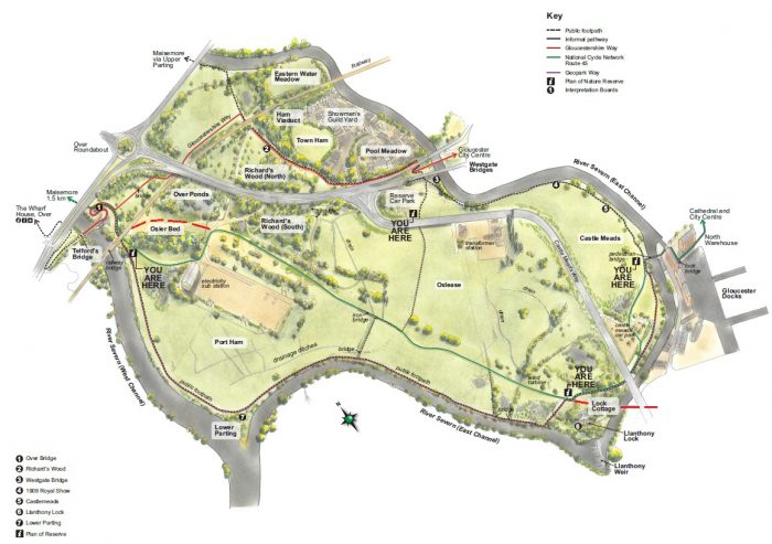 The first half of the route is shown approximately in red on the satellite image below.
 The approximate route of the old railway branch (Google Maps) runs through what is now the Alney Island Nature reserve.
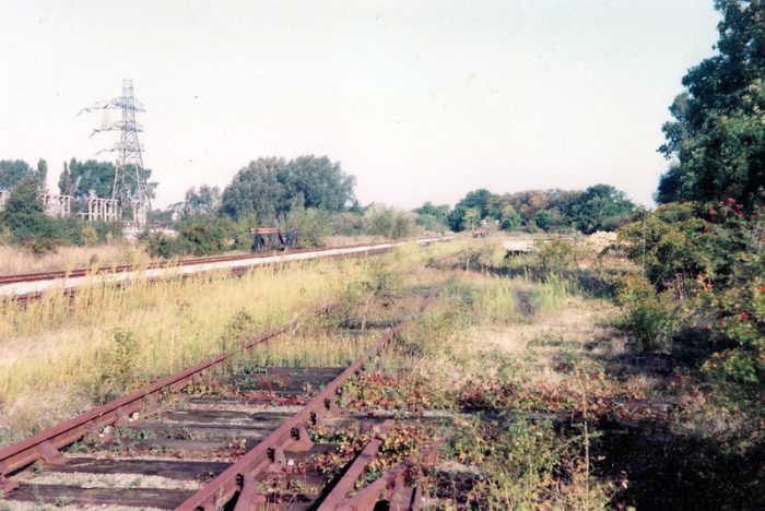
  The northerly end of the Over sidings on the Llanthony branch. The picture was taken looking to the Northwest soon after closure in the 1980s, (c) M.R. Phelan (CC BY-SA 2.0) [26]
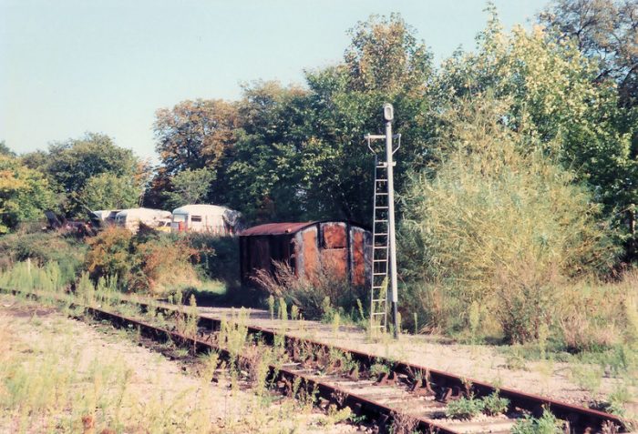 The former GWR Llanthony (Gloucester Docks) branch line at the western end of Over Sidings, shortly after closure when the track was still in-situ. 19th September 1989, (c) Roger Marks. [16]
 The northerly end of the Over sidings on the Llanthony branch. The picture was taken looking Southeast soon after closure in the 1980s, (c) M.R. Phelan (CC BY-SA 2.0) [27]

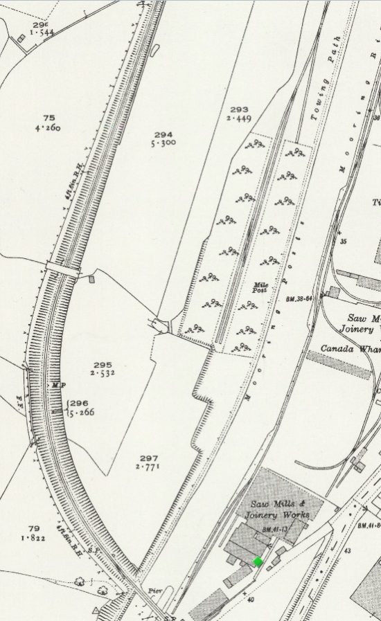
 Two extracts from the 4th Edition of the 25″ OS Map showing the sidings immediately to the South of the South Wales Main Line on the Llanthony Docks Branch on Alney Island. [3]
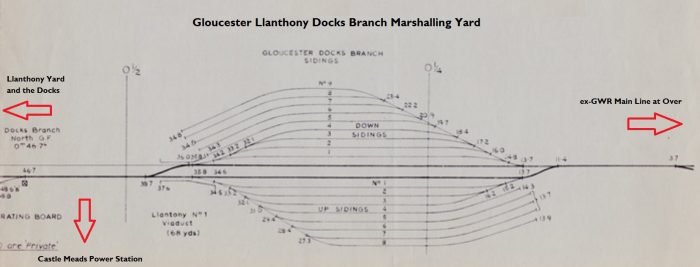 The BR map of the ex-GWR Gloucester Docks Branch Sidings Yard amended to November 1969. This is an amended drawing from the Stephen Mourton Collection. [15]
The remains of Over sidings on the ex-GWR Gloucester Docks branch. 19th September 1989, (c) Roger Marks. [18]

BR Pannier 0-6-0T active in Over Sidings in 1959. Notice the shunter’s truck behind the loco. The view looks SE from near Over Bridge, towards Gloucester Docks on the Over Branch, ex-GWR. Gloucester Docks was served by this branch from Over and also by an ex-Midland branch to the south at High Orchard and from Tuffley. ‘Modern’ ‘1600’ class 0-6-0T No. 1616 (built 12/49, withdrawn 10/59) has a spark-arrestor because of all the timber traffic dealt with at the Docks, (c) Ben Brooksbank (CC BY-SA 2.0) [7]

Looking back Northwest along the route of the old railway from approximately the location of the junction with the Power Station sub-branch. [28]
 EAW021182 – Britain From Above. Castle Meads Power Station and environs, Gloucester, from the east, 1949. The Llanthony Docks Branch runs across the top of the image with the marshalling sidings just off the right side of the image. [8]
 This enlarged detail shows the Llanthony Branch heading towards the sub-branch which served the power station [8]
 An extract from the 25″ OS Map from the 1950s. The siding serving Castle Meads Power Station can be seen curving away from the docks branch at the bottom of the extract. [3]
  The Llanthony Branch – the disused former GWR branch from Over Junction to Llanthony Yard in Gloucester Docks. Seen here on 19th September 1989, it had closed a few years previously but the track had not yet been lifted, (c) Roger Marks. [14]
 Llanthony Branch – the former GWR Llanthony (Gloucester Docks) branch line shortly after closure when the track was still in-situ. 19th September 1989, (c) Roger Marks. [19]
 The junction where the spur that served Castle Meads power station diverged from the former GWR Gloucester Docks branch. 19th September 1989, (c) Roger Marks. [17]
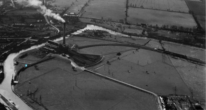 EAW021187 – Britian From Above. Castle Meads Power Station and environs, Gloucester, 1949. This superb panorama shows the full extent of the sub-branch or spur which served Castle Meads Power Sation and shows the Llanthony branch running into the docks sidings. [20]
 EAW021186 – Britain From Above. Castle Meads Power Station and environs, Gloucester, 1949. This photograph is taken looking North across the Power Station and again provdes a fullview of the sub-branch/spur. This time the Llanthony Sidings are fully visible. [25]
Wikipedia tells us that “Castle Meads Power Station was opened in December 1942. [22] It was built to replace the electricity supply from Gloucester Corporation’s works on Commercial Road. Castle Meads was one of two ‘war emergency’ stations intended to spread the risk due to war damage. [23] The other station was at Earley near Reading. … Coal was brought to the station by rail on the Great Western Railway’s Docks branch from Over, and by barge. [22][24] Once at the station, coal was transported toward the boilers by a fireless locomotive, one of only 162 ever built in Britain. It was built by Andrew Barclays of Kilmarnock in 1942, carrying the works number 2126. After the closure of the power station, the locomotive was preserved at the National Waterways Museum in Gloucester.” [21][24]
As we have noted, the power station was served by a fireless locomotive. There are a few photographs of this locomotive in its place of work in both monochrome and colour on flickr. Please follow these links: https://www.flickr.com/photos/curly42/35214968686; https://www.flickr.com/photos/31514768@N05/3388340802/in/faves-36406072@N02; https://flic.kr/p/SMkAUG; https://flic.kr/p/9mSp7s. [31]
After becoming redundant Andrew Barclay No. 2126 found its way into the collection of the National Waterways Museum at Gloucester Docks. Fireless 0-4-0 locomotive built by Barclay in 1942 (No.2126) for the Castle Meads Emergency Power Station, Gloucester in the livery of the CEGB. Withdrawn 1962. At the National Waterways Museum, Gloucester Docks in September 2009, (c) Hugh Llwelyn (Creative Commons Attribution Share-alike license 2.0). [33]
 Another view of fireless 0-4-0 locomotive built by Barclay in 1942 (No.2126) for the Castle Meads Emergency Power Station, Gloucester in the livery of the CEGB. Withdrawn 1962. At the National Waterways Museum, Gloucester Docks in September 2009, (c) Andrew Bone (Creative Commons Attribution Share-alike license 2.0). [34]
The sub-branch which served the power station extended beyond the coal loading facilities to a wharf on the bank of the River Severn. On the way it crossed a bridge which allowed flood drainage off the island. Tne YouTube video (https://youtu.be/ZwQT5JQfBcM. [29]) shows both the bridge below in its refurbished condition, and the wharf as it is in the early 21st century. The bridge on the short branch that served Castle Meads Power Station. The branch opened in 1943. It closed in 1970 and this section now forms a pathway linking a car park on the power station site to Gloucester Docks. 29th March 2009, (c) Roger Marks. [32] The bridge location is flagged on aerial image EAW021187 above.
The Docks branch continued Southeast from the junction with the spur to the power station and then crossed the river by means of a swing girder bridge.

The approximate route of the branch line as it approaches the docks sidings (Google Earth).
 Looking back to the Northwest along the Branch line from the point marked ‘X’ on the satellite image immediately above. At this point the path for the nature reserve and the old railway route diverge, (c) John Winder (Creative Commons Attribution Share-alike license 2.0). [30] This point can been picked out in the YouTube Video (https://youtu.be/ZwQT5JQfBcM which then shows the area beyond the turn of the footpath going towards the bridge over the river. [29]).
 An extract from EPW024157 – Britain from Above. The River Severn Lock and the approaches to the Llanthony Bridge over the Eastern branch of the River Severn. [38] The sign in the colour photograph above is positioned just of the top left corner of this image.
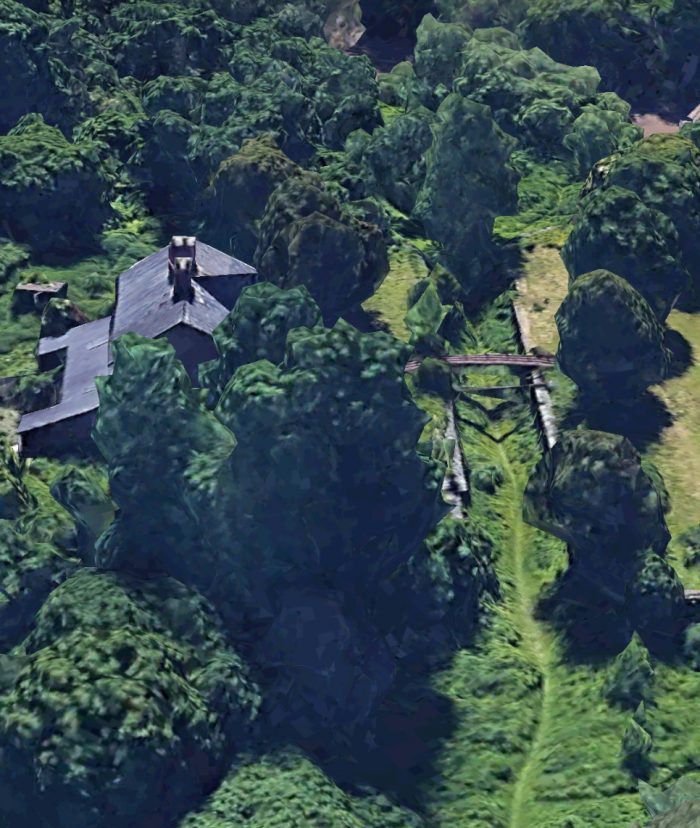 3D aerial image of the Lock in the 21st Century (Google Earth).
 An extract from EPW037837 – Britain From Above. This shows the embankment and approach spans to the Llanthony Swing Bridge which gave access across the River Severn into Llanthony sidings. [37]
 Another extract from EPW037837 – Britain From Above. The Llanthony swing bridge over the branch of the River Severn and the footbridge which formed the gateway to the Llanthony Sidings. [37]
 A small extract from EAW012210 – Britain From Above. [36] This image shows the footbridge at Llanthony Road level-crossing and the first point at the throat of the sidings for the Docks in Gloucester.

Llanthony Swing Bridge from the North This bridge only ever carried single track. One thing not apparent in this view is that the track is still in place on the bridge, despite it being 25 years or so (at least) since the last train crossed, (c) John Winder (Creative Commons Attribution Share-alike license 2.0) [42]
 A track level view of Llanthony swing bridge, Gloucester. It carried the GWR Over Junction to Gloucester Docks branch over the eastern channel of the River Severn, (c) Roger Marks. 25th March 2006. [39]
 3D Image of Llanthony Swing Bridge in the early 21st century (Google Earth).
 2D satellite image of the swing bridge in the 21st century (Google Earth).
 Looking East under the Swing Bridge (c) John Winder (Creative Commons Attribution Share-alike license 2.0) [40]

The swing bridge again. This photograph shows the former footbridge
Shot from directly underneath, this shows the parlous state of the old footbridge. Hidden by the steel bridge pier to the left of centre is the remains of the swinging mechanism, last operated in 1922, (c) John Winder (Creative Commons Attribution Share-alike license 2.0) [41]
Hugh Conway-Jonest says that, “each girder was fabricated from iron plates riveted together, the upper flange being in the shape of a balloon and the lower flange triangular. The pivot was off-centre, so that two-thirds of the span’s length crossed the river passage and the shorter tail section carried more than enough additional weights to provide a counter balance, the excess being supported by two wheels running on a section of circular track. The main pivot was supported on a central group of six 14in square piles, and two side-wheels ran on a 6ft radius circular track supported by 14in and 12in piles.” [43: p19]
To facilitate the operation of the bridge, an hydraulic press was used to carry much of the weight of the swinging span, so reducing the load on the roller shells and permitting the bridge to turn easily. [43: p19]
Hugh Conway-Jones continues: “The importance of this design is that it is believed to be the first railway swing bridge to use hydraulic power. … By using an hydraulic press to lift the span, the load on the wheels was much reduced, making turning much easier.” [43: p20]
In 1890 and 1891 a 5 month closure of the bridge was required to replace the timber pier supporting the pivot of the bridge with cast iron cylindrical columns. By 1899 it was necessary to replace the swinging section of the bridge with a riveted steel span, Possibly due to a failure of the hydraulic system. It seems as though it was necessary to employ horses to turn the bridge span. Hugh Conway-Jones says: “Because of the length of time this could take, the foreman in charge of the railway yard frequently refused to open the bridge because it formed part of the railway shunting yard.” [43: p21]
The 1899 structure remains in place in the 21st century. Rails are still in place but the structure appears not to be in the best of conditions.
Immediately East of the swing bridge a footbridge was installed to allow pedestrians to pass when the level-crossing at Hempsted Lane had to be closed to permit shunting movements. Llanthony Road level crossing and its distinctive Tubewright footbridge. The crossing took the road across the former GWR branch from Over Junction to Llanthony Quay in Gloucester Docks. The line closed in the mid 1980s. This part of Llanthony Road has now become the A430 and instead of curving to the right it now carries straight on, crossing the river and joining the A417 at Over Causeway. (c) Roger Marks, 19th September 1989. [35]
 Looking North early in the 21st century, the footbridge is a distant memory. It sat approximately in front of the grey panelling. The old road curved round to the right at this point (Google Streetview).
 An extract from EPW037837 – Britain From Above. Llanthony Dock Sidings in 1932 view from the West. the footbridge frames the entrance to the Yard. [37]
As can be seen in the aerial image above, the single line which crossed the River Severn branched out into extensive sidings that terminated just short of the Western quay wall of the canal/docks. Branching away to the left of the above photograph is a branch which ran between the River Severn and the docks, eventually crossing the northern locks which provided access from the docks to the river and linking with the sidings on the East side of the docks. To the right of the picture, running behind the buildings which can be seen on the right of the image, another siding served the southern quayside of the docks and ran further down the canal. Llanthony Railway Yard as shown on the 1st Edition of the 25″ Ordnance Survey Maps. This extract shows the Yard at a relatively early stage in its development in broad-gauge days. Later editions show some changes. The lines running North were mixed gauge as the GWR and MR shared them. Crossing Lanthony Bridge to the right of the extract was a line crossing the bridge connecting the two sides of the dock basin.[44]
 Llanthony Railway Yard as shown on the 4th Edition of the 25″ Ordnance Survey Maps. This map extract better reflects what can be seen on the aerial photograph of the Yard above. Immediately to the North of Llanthony Priory the buildings to the right of the aerial image can be seen, these were sheet works used for the repair and conditioning of the tarpaulins used to cover open wagons. [43: p21] The large building at the centre-bottom of this extract (and the top-right of the following extract) is a transit shed which according to Conway-Jones, “provided space for temporary storage and customs inspection of goods being transferred from ships to railway wagons. It was particularly used for handling cargoes (principally sugar) imported by the regular steamers of the Bristol Steam Navigation Company.” [43: p21] In addition to these changes, a link curves from the North side of the Yard to the quayside where the sidings have been developed to improve access and to serve the transit shed. To the North of Llanthony Road the arrangements are much as they were on the 1st Edition Map. By this time all of the track shown on the map extract would have been standard-gauge. [44]
 By the time of this later map series, this extract for the OS Map shows that the railway company had extended their lines to the south of Llanthony Yard to serve premises around the new Monk Meadow Dock. [44]
 Looking South from Llanthony Railway Yard along the Canal Quay with the ex-GWR transit shed on the right, (c) Roger Marks. [45]
 A few steps further South looking South along the side of the Transit Shed again, (c) Roger Marks. [46]
 Looking North along the transit shed on the GWR’s Llanthony Quay in Gloucester Docks. 16th April 1991. The site is now part of the campus of Gloucestershire College of Art and Technology, (c) Roger Marks. [47]
 An extract from EAW012211 – Britain From Above. This image provides a view of the GWR transit shed in 1947 across the Llanthony Secunda Priory site. [48]

Looking South along Llanthony Quay in 2020 (Google Earth) The large building(s) on the site of Llanthony Railway Yard make up the campus of Gloucestershire College of Art and Technology. Llanthony Road is at the bottom of the image and the new St. Ann Way at the top. Llanthony Quay extends beyone the top of the image by some hundreds of yards to Monk Meadow Dock.
Llanthony Quay extended south along the canal to Monk Meadow Dock which was opened in 1892 to provide additional quay-space for the timber trade, and it was later used for receiving petroleum products. To the south of the dock, Monk Meadow Quay was built beside the canal in 1965 for the discharge of timber from motor coasters. [49]
Monk Meadow Dock is shown on the aerial images below The first is taken looking West across the Gloucester and Berkeley Canal in 1928.
The second looks North across Monks Meadow Dock right along the Llanthony Quay to the Llanthony Railway Yard. It was taken in 1932 and is an excellent study of the use of these sidings and the Yard.
The transit shed at Monk Meadow can be seen on the first image looking bright and new to the right-hand side of the Dock. It is centre-left on the North side of the Dock in the second image. An extract from EPW024167 – Britain From Above. This image shows Monk Meadow Dock in 1928. [50]
 An extract from EPW037836 – Britain From Above. Looking North towards the Main Basin of the Docks with Monk Meadow Dock visible in the foreground and Llanthony Railway Yard towards the top of the extract. [51]
 A view looking East through the canopy of the transit shed at the West end of the North side of Monk Meadow Dock in 1992. The dock is now a marina, (c) Roger Marks. [54]
 A view of the transit shed on the south side of Monk Meadow Dock. It was taken in the 1950s and is included here by kind permission of Paul Barnett of the Friends of Purton. Paul is the author of ‘Fore and Aft… Lost Ships of the Severn Sea.’ [52][53] The presence of the oil storage tanks on the horizon point towards this being the shed on the south side of the Dock.
As well as the quayside rails, a branch from Llanthony Yard ran south behind the transit shed on Llanthony Quay and then crossed Abbey Road to serve an number of oil storage depots and provide good access to Monk Meadow Docks sidings as shown on the map extract below. The sinuous curve of these lines is well illustrated on the map extract and on the Aerial image next below.
 An extract from EAW012196 – Britain from Above. The extract shows the route of the branch running on the West side of the Industrial Area and serving Monk Meadow Dock. The photograph was taken in 1947. [55]

An extract from the 4th Edition 25″ OS Map. [44]
An extract from the 4th Edition 25″ OS Map. [44]

The length of the canal south of Gloucestershire College of Art and Technology is shown as it is in the early 21st century on these satellite images from Google Maps.

Branch on this side of the canal. Installed by the LMS to gain access to the sidings on the West of the Canal. We followed the route of this line on the East side of the Canal to the point where it crossed to the Hempsted side of the Canal.
The quayside lines and the New Docks Branch continue South along the West side of the Canal for only a short distance with the New Docks Branch (or the Hempsted Branch turning to cross the Canal as shown on this next map extract.
The New docks branch and the bridge over the canal are long-gone. The area has been extensively developed as housing. The first satellite image extends from the College in the North, across St. Ann Way, past Monk Meadow Dock which is now a marina and further along the canal-side. Domestic dwellings on The West side of the canal sit within a stone’s throw of significant industrial premises to the East.
The new road has been built along the line of the ancient New Docks Branch. The approximate alignment of the old railway is shown on the second of the two images at the point where it curved towards the canal , crossing it on a swing bridge which was removed in the middle of the 20th century.
This brings us to the end of our study of the railways associated with Gloucester Docks. There is more to consider further to the South at Sharpness Docks but those docks and their railways need to be left for another occasion. We have literally only looked at a very short length of the Canal. There is so much more to explore along its length and in the areas either side of its route.
A useful point to start an exploration on line is on the website owned by Hugh Conway-Jones who is an acknowledged expert on the history of the docks and the canal. The link to that website is:
https://www.gloucesterdocks.me.uk
References
- Neil Parkhouse; British Railway History in Colour Volume 1: West Gloucester & Wye Valley Lines; Lightmoor Press Ltd, Lydney, Gloucestershire. cf. http://lightmoor.co.uk/books/supplement-to-west-gloucester-wye-valley-lines/L8399, accessed on 1st June 2020.
- New Bridge at Over Junction, Western Region; in The Railway Gazette 4th May 1951, p565, found at https://sites.google.com/site/gloucestershirerailwaymemories/home/a-new-way-and-works/new-bridge-at-over-junction which also carries additional information and a parallel article which was first published in the BR ‘Western Region News.’ The latter article covers the construction of the newer bridge. Gloucester Railway Memories us a site complied by the author Stephen Mourton. He comments: “This website is completely non-commercial and compiled purely as a hobby, I hope that readers will find it of interest. All articles are copyright of the author and may not be reproduced without permission. … I don’t mind others using my copyright pictures on another website provided that it is non-commercial use.”
- https://maps.bristol.gov.uk/kyp/?edition=glos, accessed on 16th May 2020.
- https://commons.wikimedia.org/wiki/File:Over_Junction_geograph-2472000-by-Ben-Brooksbank.jpg, accessed on 31st May 2020.
- https://www.geograph.org.uk/photo/4425245, accessed on 31st May 2020.
- https://www.geograph.org.uk/photo/1937314, accessed on 31st May 2020.
- https://en.m.wikipedia.org/wiki/File:Gloucester_Over_Sidings_geograph-2565694-by-Ben-Brooksbank.jpg
- https://www.britainfromabove.org.uk/en/image/EAW021182, accessed on 3rd June 2020.
- https://maps.bristol.gov.uk/kyp/?edition=glos, (2019 Q2 Base Map) accessed on 19th May 2020.
- Ben Ashworth; The Last Days of Steam in Gloucestershire; Amberley Publishing, 2009.
- Ben Ashworth; The Last Days of Steam in Gloucestershire A Second Selection; Amberley Publishing, 2013.
- Colin Maggs; The Branch Lines of Gloucestershire; Amberley Publishing, 2013.
- Gloucestershire Archives, Clarence Row, Alvin Street, Gloucester. GL1 3DW, at the time of writing the Archives are closed to public access because of COVID-19.
- https://www.flickr.com/photos/rpmarks/13590136744/in/photolist-mGV1bu-NC6UdN-MQQ5zS-d3pAom-8N16He-yXX5GH-8N15nT-uvZ7Ab-bxVUAw-bEgRG3-DHkZe4-aFEGBZ-7aWPNr-aSXm9V-5w34Ly-GMjhfx-ak1hdU-ci3PRu-7oV8n1-FzqJaC-bngnnW-bFq8nK-dJ96Ce-d4oyN7-adXzGa-ccFh9q-bLkmZa-dJcxXz-ubMRWb-a39pHr-dV3LgF-dexgKR-6Do9JN-aFEFya-b5yBDt-8Wgyhg-d4oAN3-dq57QC-f47T7B-8Xbor1-gZMCPq-bAPHXb-baXECF-dJaAsP-5npTsX-dNzsnN-ccFfTU-ARJFtW-bJpUW2-dBj9vC, accessed on 5th June 2020.
- https://sites.google.com/site/gloucestershirerailwaymemories/home/a-new-way-and-works/gloucester-dock-branch-sidings-and-llantony, accessed on 4th June 2020. Gloucestershire Railway Memories is a site published by Stephen Mourton. He comments: “All articles are copyright of the author and may not be reproduced without permission. Photos credited to Robin Stanton, Stephen Mourton and Stephen Mourton collection are also copyright of the author. I don’t mind others using my copyright pictures on another website provided that: It is non-commercial use … [and] you credit the source of the picture as [the] Stephen Mourton collection.”
- https://www.flickr.com/photos/rpmarks/22069829698/in/photolist-zCeDt9-5kWsVr-ZPRrAD-A81ge9-2eD52mb-R1aR62-ucb8dn-2iw1cDs-fQfWct-bgMxZD-afMbgv-b2UkcD-jAhbFe-DyZNGz-DyZU8V-5kHusR-ubMRWb-7BHWHb-Dj7tjT-DF2J6Y-NC6UdN-8N16He-8N15nT-bEgRG3-aFEGBZ-7oV8n1-adXzGa-dJcxXz-9bP8qM-6Do9cE-ArqK5s-BByqpD-w7byw5-amVikV-AGEsMR-A3gMTE-u9QhmL-yXNocm-zX9eUM-B8AemT-8Wq2ZN-cDGMBN-e5iZyC-b2UjRF-tf8VQ5-mGV1bu-MQQ5zS-d3pAom-yXX5GH-uvZ7Ab, accessed on 5th June 2020.
- https://www.flickr.com/photos/rpmarks/49794707317/in/photolist-2iSbTEv-248dmH2-2iSak2W-2eF3w5L-22b7ugq-zCeDt9-5kWsVr-ZPRrAD-A81ge9-2eD52mb-ZkXMPF-R1aR62-ucb8dn-2iw1cDs-fQfWct-bgMxZD-afMbgv-b2UkcD-jAhbFe-DyZNGz-DyZU8V-5kKUHy-Heyqxg-DF2MSq-9bP8qM-5kHusR-6Do9cE-ArqK5s-7BHWHb-BByqpD-Dj7tjT-w7byw5-DF2J6Y-amVikV-AGEsMR-A3gMTE-u9QhmL-yXNocm-zX9eUM-B8AemT-8Wq2ZN-cDGMBN-e5iZyC-b2UjRF-tf8VQ5-mGV1bu-NC6UdN-MQQ5zS-d3pAom-8N16He, accessed on 5th June 2020.
- https://www.flickr.com/photos/rpmarks/49794402436/in/photolist-2iSak2W-2eF3w5L-22b7ugq-zCeDt9-5kWsVr-ZPRrAD-A81ge9-2eD52mb-ZkXMPF-R1aR62-ucb8dn-2iw1cDs-fQfWct-bgMxZD-afMbgv-b2UkcD-jAhbFe-DyZNGz-DyZU8V-5kKUHy-Heyqxg-DF2MSq-9bP8qM-5kHusR-6Do9cE-ArqK5s-7BHWHb-BByqpD-Dj7tjT-w7byw5-DF2J6Y-amVikV-AGEsMR-A3gMTE-u9QhmL-yXNocm-zX9eUM-B8AemT-8Wq2ZN-cDGMBN-e5iZyC-b2UjRF-tf8VQ5-mGV1bu-NC6UdN-MQQ5zS-d3pAom-8N16He-yXX5GH-8N15nT, accessed on 5th June 2020.
- https://www.flickr.com/photos/rpmarks/21634873674/in/photolist-yXNocm-zX9eUM-B8AemT-8Wq2ZN-cDGMBN-e5iZyC-b2UjRF-tf8VQ5-mGV1bu-NC6UdN-MQQ5zS-d3pAom-8N16He-yXX5GH-8N15nT-uvZ7Ab-bxVUAw-bEgRG3-DHkZe4-aFEGBZ-7aWPNr-aSXm9V-5w34Ly-GMjhfx-ak1hdU-ci3PRu-7oV8n1-FzqJaC-bngnnW-bFq8nK-dJ96Ce-d4oyN7-adXzGa-ccFh9q-bLkmZa-dJcxXz-ubMRWb-a39pHr-dV3LgF-dexgKR-6Do9JN-aFEFya-b5yBDt-8Wgyhg-d4oAN3-dq57QC-f47T7B-8Xbor1-gZMCPq-bAPHXb, accessed on 5th June 2020.
- https://britainfromabove.org.uk/en/image/EAW021187, accessed on 3rd June 2020.
- https://en.wikipedia.org/wiki/Castle_Meads_Power_Station, accessed on 5th June 2020.
- https://glostransporthistory.visit-gloucestershire.co.uk/Llanthon.htm, accessed onj 2nd June 2020.
- The Electricity Council; Electricity Supply in the UK: a chronology; The Electricity Council, London, 1897, p55-56.
- https://glostransporthistory.visit-gloucestershire.co.uk/Railgloschur2.htm, accessed on 1st June 2020.
- https://britainfromabove.org.uk/en/image/EAW021184, accessed on 3rd June 2020.
- https://www.geograph.org.uk/photo/5886444, accessed on 5th June 2020.
- https://www.geograph.org.uk/photo/5886447, accessed on 5th June 2020.
- https://www.geograph.org.uk/photo/2460936, accessed on 6th June 2020.
- Search for Alney Island Railway marshalling yard Gloucester; https://youtu.be/ZwQT5JQfBcM, accessed on 6th June 2020.
- https://www.geograph.org.uk/photo/4166438, accessed on 6th June 2020.
- https://www.flickr.com, accessed on 6th June 2020.
- https://www.flickr.com/photos/rpmarks/3704816050, accessed on 6th June 2020.
- https://commons.wikimedia.org/wiki/File:Barclay_2162_(6543576493).jpg, accessed on 6th June 2020.
- https://commons.wikimedia.org/wiki/File:1942_Fireless_Locomotive_built_by_Andrew_Barclay_of_Kilmarnock_(16781487178).jpg, accessed on 6th June 2020.
- https://www.flickr.com/photos/rpmarks/4342401604/in/photolist-7BHWHb-22knicn-SuRoqo-zBC47R-5PiVXk-5sjMdD-6nANRx-uR8by7-5NPrxb-6xLVDB-5PodwW-6n4quw-6drPk7-67ns23-5NqCtx-nmsnde-ZPRrAD-7BE2RN-74Sd2s-5NpVKj-6drPR9-PkoLUv-ww6LyK-WAMR5i-zCeGzE-23gWou2-256uBNT-29JnKx1-7ztgcg-22b7ugq-2ircCqV-2iVEJ5f-zCeDt9-2iLDdSM-ygFyD4-5kWsVr-euPHwM-N3C4r7-KVgk2r-2iSbTEv-27iRqL1-Cp3Dqv-2eD52mb-A81ge9-R1aR62-ZkXMPF-DxgKk4-fQk1SV-savVqB-2hsaU8s, accessed on 7th June 2020.
- https://britainfromabove.org.uk/en/image/EAW012210, accessed on 7th June 2020.
- https://britainfromabove.org.uk/en/image/EPW037837, accessed on 7th June 2020.
- https://britainfromabove.org.uk/en/image/EPW024157, accessed on 7th June 2020.
- https://www.flickr.com/photos/rpmarks/2965324852/in/photolist-5w34Ly-GMjhfx-ak1hdU-7oV8n1-FzqJaC-bngnnW-bFq8nK-dJ96Ce-d4oyN7-adXzGa-ccFh9q-bLkmZa-dJcxXz-a39pHr-dexgKR-b5yBDt-dq57QC-bAPHXb-dJaAsP-bzbZKB-6D4Wg2-8UJ98L-CV67ZE-dV3LgF-6Do9JN-aFEFya-8Wgyhg-d4oAN3-f47T7B-8Xbor1-gZMCPq-baXECF-5npTsX-dNzsnN-ccFfTU-ARJFtW-bJpUW2-dBj9vC-bkLKkq-5kFrhe-5ry85B-edBv71-dJaBea-gZMJrM-6NiztG-5nGQVw-bspaaJ-bx8iUL-bEjGaf-zNmoXn, accessed on 3rd June 2020.
- https://www.geograph.org.uk/photo/4166412, accessed on 8th June 2020.
- https://www.geograph.org.uk/photo/4166421, accessed on 8th June 2020.
- https://www.geograph.org.uk/photo/4166407, accessed on 8th June 2020.
- Hugh Conway-Jones; Llanthony Railway Yard and Swing Bridge over the Severn; Gloucestershire Society for Industrial Archaeology Journal, 2005: p19-27.
- https://maps.bristol.gov.uk/kyp/?edition=glos, accessed on 8th June 2020.
- https://www.flickr.com/photos/rpmarks/6585094591/in/photolist-2iPiQRi-2iSwnW2-2iL3Wqb-amY7qC-7A2fqe-2j1jj6H-bgMxZD-2iLhyWU-e9D2UZ-EgfATi-5FGsbN-2itBUgc-2iSN2qM-5NuU6f-6yXcqW-5kKUHy-d3XRAh-2i5Yzru-2ePnwxT-NpdPzv-2hAPqaf-Xafmyq-7A2fe8-drLPW8-dBC5Fd-amKZSN-2iMYfBV-6bnzCJ-aN2Nyz-66F24t-b2UkcD-5jcB1d-8Wq2ZN-67idCT-6drPdS-Heyqxg-6b7mHT-7y6wEV-AbgfyD-6gBeLr-eNL7BG-2eP9M7u-7BQBm9-QYj6Zr-R388nV-2iRLLba-2iS1f4K-2hCowc8-2eKDy1e-9shLnG, accessed on 1st June 2020.
- https://www.flickr.com/photos/rpmarks/22395396806/in/photolist-2eRiVyt-2iLDthK-2ixkJf9-2iLBPrq-dV9aTq-2iv54Xk-7A2fe8-2eP9M7u-6bnzCJ-AbgfyD-7A2fqe-2iSwnW2-6gBeLr-2ipg6oF-6b7mHT-2eLETmG-2eLERXu-QYj6UB-24cPqcc-te3ZCL-2ePnwiK-26Lnw1X-QYj6Zr-zBC47R-2eKDy1e-2iSbTEv-2eF3w5L-248dmH2-2iSak2W-22b7ugq-zCeDt9-5kWsVr-ZPRrAD-A81ge9-ZkXMPF-2eD52mb-R1aR62-2iw1cDs-ucb8dn-fQfWct-afMbgv-b2UkcD-Heyqxg-jAhbFe-DyZNGz-DyZU8V-DF2MSq-5kKUHy-9bP8qM-bgMxZD, accessed on 1st June 2020.
- https://www.flickr.com/photos/rpmarks/7914640214/in/photolist-ak1hdU-7oV8n1-FzqJaC-bngnnW-bFq8nK-dJ96Ce-d4oyN7-adXzGa-ccFh9q-bLkmZa-CV67ZE-a39pHr-dV3LgF-6Do9JN-f47T7B-gZMCPq-bAPHXb-5ry85B-6NiztG-bspaaJ-zNmoXn-dJcxXz-aFEFya-dexgKR-b5yBDt-8Wgyhg-d4oAN3-dq57QC-8Xbor1-baXECF-dJaAsP-5npTsX-dNzsnN-ccFfTU-ARJFtW-bJpUW2-dBj9vC-bzbZKB-bkLKkq-edBv71-5kFrhe-dJaBea-gZMJrM-5nGQVw-6D4Wg2-bx8iUL-8UJ98L-bEjGaf-6cU957-bKJnVZ, accessed on 1st June 2020.
- https://www.britainfromabove.org.uk/image/eaw012211, accessed on 9th June 2020.
- https://www.gloucesterdocks.me.uk/gloucester/docks.htm, accessed on 1st June 2020.
- https://britainfromabove.org.uk/image/epw024167, accessed on 10th June 2020.
- https://www.britainfromabove.org.uk/image/epw037836, accessed on 10th June 2020.
- http://www.friendsofpurton.org.uk/canalhistory.html, accessed on 10th June 2020.
- https://mythornbury.co.uk/thornbury/purton-hulks & https://www.gazetteseries.co.uk/news/18153625.dursley-historian-documents-lost-ships-river-severn, both accessed on 11th June 2020.
- https://www.flickr.com/photos/rpmarks/7646592736/in/photolist-5kHusR-6Do9cE-ArqK5s-u9QhmL-yXNocm-B8AemT-tf8VQ5-e5iZyC-8Wq2ZN-mGV1bu-NC6UdN-d3pAom-8N16He-8N15nT-uvZ7Ab-7aWPNr-ci3PRu-Dj7tjT-ubMRWb-7BHWHb-BByqpD-w7byw5-DF2J6Y-amVikV-AGEsMR-A3gMTE-zX9eUM-cDGMBN-b2UjRF-MQQ5zS-yXX5GH-bxVUAw-bEgRG3-DHkZe4-aFEGBZ-aSXm9V-5w34Ly-GMjhfx-ak1hdU-7oV8n1-FzqJaC-bngnnW-bFq8nK-dJ96Ce-d4oyN7-adXzGa-ccFh9q-bLkmZa-CV67ZE-a39pHr, accessed on 11th June 2020.
- https://www.britainfromabove.org.uk/en/image/EAW012196, accessed on 11th June 2020.
- Email correspondence from Roger Smith on 11th June 2020.

Llanthony Foot Bridge is currently stored in pieces at the old Newent Railway Station.
There is now a 32MW gas fired reciprocating engine power station on the Sudmeadow on the bank of the river. It sits on the gas main. It is also worth noting that the posts with a black & yellow top, which cross the whole area from South to North, mark the national oil pipeline.