
Leckhampton Road and Beyond!
This article covers the length of the Tramroad up Leckhampton Road and through the Southern ‘suburbs’ of Cheltenham to meet what was the mainline of the Gloucester and Cheltenham Tramroad.
Before covering the route in detail, it is worth noting that a presentation was given in 2010 by Wendy Ellyatt covering the History of the Tramroad. This presentation can be foolowed by following this link: http://www.authorstream.com/Presentation/wendyellyatt-478472-the-history-of-southe-cheltenham-tramroad. [30] The presentation was prepared as part of the work ont he renovation of the Norwood Triangle referred to later in the text of this article.
At the end of the last article about this Tramroad we noted that the branch from Leckhampton Hill into Cheltenham headed North away from the quarries and Leckhampton Hill. The quarry tramway lines were served by a Depot alongside Leckhampton Road. The Depot was built in about 1810. It became the location of Leckhampton Industrial Estate (although I think it has now been developed for housing). In 1923 the depot was transferred to Southfield Farm. [1: p41]
The tramroad only had a short distance to travel between the bottom of Bottom Incline and the Depot. Ownership of the length of tramway from the incline to the depot in the early years is not entirely clear. The 1809 Act gave powers to the Tramroad Company to connect with the tramroads on Leckhampton Hill but included a clause which allowed Trye to complete the connection should the Company not do so. It is therefore clear, given that Trye did make the connection and built a length of 950 yards or so which included Middle and Bottom incline, that the line as far as the bottom of Bottom Incline belonged to the quarry company but the point North of the Incline at which the lines became the responsibility of the Tramroad Company is not entirely clear. [2: p50]
Although gradients on the Tramroad were generally relatively shallow, those along Leckhampton Road and particularly the length closest to the quarries were not. Bick has the gradient on the Branch averaging about 1 in 70, steepening to 1 in 35 on the approach to the bottom of Bottom Incline. [2: p32]
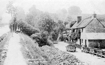 The bottom of Bottom Incline. [19] It was at this point that the public tramroad gave way to the quarry tramroads. Interestingly, Bick gives the date of this photograph as being around 1895. This is evidence that a length of the tramway alongside Leckhampton Road was retained in use after the closure of Gloucester & Cheltenham Tramroad as a whole, in 1861. Bick says: “Here the Leckhampton branch of the Gloucester and Cheltenham Tramroad met C. B. Trye’s quarry lines. c. 1895. (c) A. T. Bendall.” [2: p32a][3] Leckhampton Road/Hill can be seen on the left of the picture.
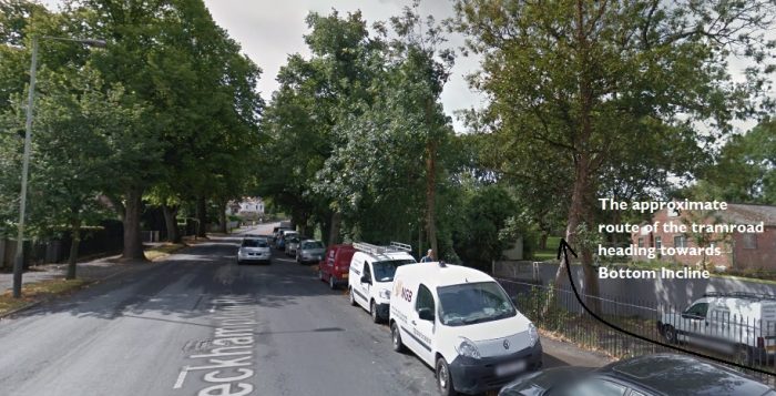 The point where the tramway from Bottom Incline drew alongside Leckhampton Road, as it is in the 21st century. The cottages in the monochrome image from the turn of the 20th century are long-gone. The old depot was located just off the the right of this picture. (Google Streetview).
North of the Depot, the old tramroad ran along the west verge of Leckhampton Road towards Cheltenham.
When we see images, later in this article, of a tramway in the centre of Leckhampton Road, we need to remember that the tramway in those images is a later tramway which operated in the early 20th Century and which was primarily a passenger tramway. The image below comes from the year 1900, the trees in the verge have just been planted, there is no evidence of a tramway in the centre of the road and the old tramway rails are still evident to the west of the road, on the right of this picture. 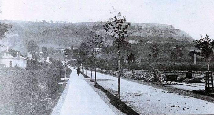 Leckhampton Road under reconstruction. The old tramroad rails appear still to be available at this time as the tramroad wagon on the right of the image testifies. Although some sources do suggest that the rails were lifted when the old tramway closed in 1861, [4: p50][5][6] Bick is clear that the length at this location survived into the 1890s. He says that Trye who owned the quarries in 1861, “retained about 500 yds. of line down the side of Leckhampton Road to a point opposite the Malvern Inn, where he established a stone wharf. This bit of line, the last of the Gloucester and Cheltenham Tramroad, was not taken up until the late 1890s.” [2: p51 (and very briefly on p29)]
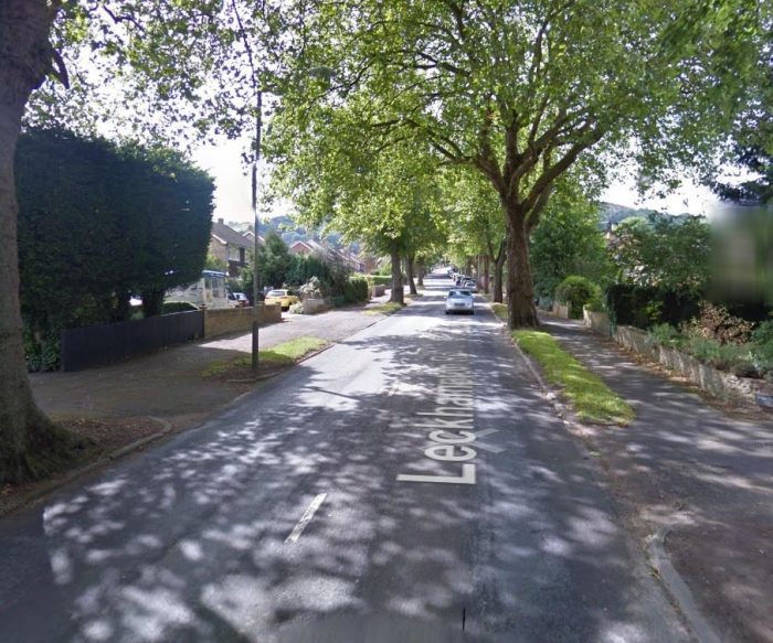 Leckhampton Road in the 21st Century at approximately the same location as the image above (Google Streetview).

I have not been able to establish the location on Leckhampton Road of this picture. I understand that it was taken in 1902 and is probably of the Cotswold Hunt. It appears that by 1902 the old tramway rails had been removed. [7]
It is nearly impossible to give an accurate date for this view. The old tramroad would have been on the right of the image and the area seems quite overgrown so must come from a slightly later date than other images below. [11]

Leckhampton Road facing South. The old tramroad would have been in the verge at the right side of the road, although no remains would have been visible when the tram in the postcard picture would have been in service. The first passenger trams appeared in Cheltenham in 1901 on a route from Lansdown to Cleeve Hill. It was two years later that a service began from Leckhampton terminus to the Norwood Arms. They had gone by 1931. It is difficult to be sure of the date of this picture but some of the trees in the verge have had time to grow a little, so perhaps close to 1910 would be a reasonable guess. [9][10] There is a black and white version of this image on the “Archive Images” website which says that it was taken in 1908. [3]

Leckhampton Road looking North in the 1940s. [8]

Both the older tramroad and the newer tramway crossed the Leckhampton Road railway bridge as they travelled North. Although the Gloucester and Cheltenham Tramroad closed in 1861 a section from Leckhampton Hill to the junction at Bath Road remained open until the advent of the 20th century. The Station opened in 1881. [16]
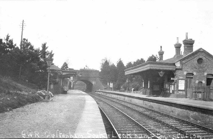
Leckhampton Railway Station in the first half of the 20th century, (c) Brian Rudman. [17]

Leckhampton Road Bridge is at the rear of this photograph of Leckhampton Station. In the 1800s, the old tramway crossed this bridge in the 20th century it was the passenger trams that did so, (c) Malcolm Mitchell. [15]

Leckhampton Road near the North end, sometime after the arrival of the trams in around 1903. [14]

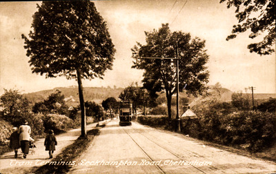
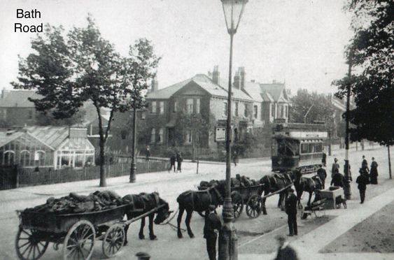
Leckhampton Road at its junction with Shurdington Road and Bath Road in around 1910. The Norwood Arms is just off the picture to the right. [12]
A similar location at the junction between Leckhampton Road and what is now the A46, Shurdington Road/Bath Road. The junction is now a roundabout.. [13] A wider angle image of the same location in the 21st century. The trough can still be seen near the centre of this image. (Google Streetview).

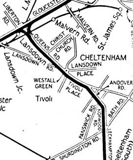
Returning to the Gloucester and Cheltenham Tramroad: heading North by North-West the old tramroad left the bounds of the highway and travelled cross-country from the present A46. The area is of course now built up but when the tramroad was first built it crossed open fields through areas which are now known as Tivoli, Westall Green and along what is now Queens Road.
D.E. Bick notes that in the middle of the 19th century the route from Westall Green to Leckhampton Road was increasingly flanked with dwellings. He goes on to say: “H.N. Tyre’s branch to Grottens Wharf gave way to Great Norwood Street and was replaced by two long sidings on ground now (1968) occupied by Messrs. Parry’s timber yard opposite the Railway Inn, Norwood Road. These became the new Grottens Wharf. A short distance up the line, sidings diverged into a large coal yard bordering Grafton Street.” [2: p18]
The same length is described by the GSIA (Gloucestershire Society for Industrial Archaeology) as follows: “The Leckhampton quarry branch left the main line immediately to the north of the present Lansdown railway station. It then ran along Queens Road, Andover Road, Norwood Street and past the Norwood Arms public house into Leckhampton Road continuing past the Malvern Inn to the depot where it met the Leckhampton quarry system.” [20: p5]
The Northern part of the Leckhampton Branch. [23: p120]
At the top of Norwood Road the line curves from travelling roughly North-South to take up a Northwest-Southeast alignment along Andover Road. This happens at a place often referred to as the Norwood Triangle.

Norwood Triangle (Google Maps)
The Norwood Triangle was at the Southern end of Great Norwood Street where it met Norwood Road. It was an open area of land formed by the junction of a number of roads close to what was at the time the Railway Inn. The pub has been redeveloped as private dwellings. In 2008, the SPJARA Residents Association was given a National Lottery grant to renovate the triangle. [28]
The excerpt (below) from an ancient map of 1843 shows the route of the tramroad in this part of Cheltenham. The roads named along the alignment are Queen’s Road and Tivoli Place. Norwood Triangle is not easily identified on the map but it is present at the North end of Norwood Road. The engraver of this map was H.W. Darby. [22] Below the 1843 map is an extract from an earlier map – Merrett’s Plan of Cheltenham – which just picks up the location of the Triangle.

 I have been unable as yet to find a full copy of the 1834 Plan of Cheltenham and have been able to find this extract on The Cheltonia Blog. [29]
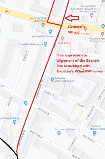
Grotten’s Wharf (Wharves)
In identifying the location of Grotten’s Wharf, it is important to remember, when reading D.E. Bick’s work and the GSIA document referred to above, that both Bick’s review of the tramroad route and that provided by the GSIA set off from Gloucester and follow the line of the Tramroad to Cheltenham and Leckhampton Hill, whereas, in this article, we have started from Leckhampton Hill. This means that the area first known as Grotten’s Wharf in the quote from Bick above was accessed by a short branch line from close to the top of Leckhampton Road.
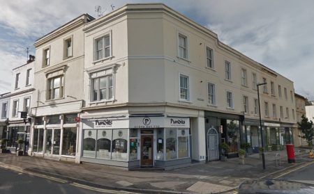
The building that was Norwood Pharmacy and before that the yard at the north end of Grotten’s Wharf branch from the Gloucester and Cheltenham Tramroad (Google Streetview).
 D.E. Bick says that a branch “was laid from the Leckhampton branch to a rural stone depot and workshops known as Grotten’s Wharf, a large area now (1968) partly occupied by the Norwood Pharmacy in Suffolk Road, Cheltenham. The line and depot was very probably made by Henry Norwood Tyre after inheriting his father’s property in 1812.” [2: p15]. The adjacent monochrome picture from the 1950s shows Norwood Pharmacy which faced Suffolk Road and was in business until sometime in the late 1970s or early 1980s. Its premises ran back along Great Norwood Street and included No. 4 Great Norwood Street. [27] The colour image above shows the same location in the early 21st century.
The locations of the Wharves and of the branch-line to Grotten’s Wharf are clarified by comments on the Cheltenham South Town website. Grotten’s Wharf was, “on a short tramway spur opposite what is now (early 21st Century) the Jolly Brewmaster in Painswick Road; another line ran along the future route of Great Norwood Street to a yard in Suffolk Road.” [24] This quote talks of two different locations, one immediately alongside the mainline and the other along a short branch.
David Elder says that “In the 1820s-30s the main stone depot (known as Grotten’s Wharf) was located on the corner of Great Norwood Street and Suffolk Road (then called Commercial Road).” [25]
Elsewhere on the Cheltenham South Town Website, the authors say: “Great Norwood Street was laid out around 1825 on land belonging to Henry Norwood Tyre. … Previously there were only fields here, the one bordering the Suffolk Road being called the “”Grattons” or “Grottens”. Through here ran the horse drawn railway bringing stone from the Leckhampton quarries to Grotten’s Wharf and this street followed the route of a spur line. Number 45, built by 1825 by a stone mason named Richard Allen, may have been the first house erected. The street is named on an 1834 map, where it is still only partially developed.” [26]
Grotten’s Wharf and its branch-line (Google Maps).

An extract from an 1855 plan of Cheltenham. [33]
“Suffolk Road was formerly known as Commercial Road and it was only partly built up by 1834. However this was already an ancient route from the Old Bath Road to Westal Green, across the open field system called Sandford Field.” [26]
The tramroad is likely to have been a catalyst in the development of much of the South side of Cheltenham.
To conclude the notes about Grotten’s Wharf, D.E. Bick mentions that in 1821 a system of tolls was introduced to manage the traffic on the Tramroad. [2: p15] This sytem mirrored similar arrangements made for traffic on the turnpike roads of the time. Nik Thomas posted a very interesting scan on the Days Gone By in Cheltenham group on Facebook. It shows an old toll permit issued at the foot of Leckhampton Hill for three trams of gravel to Grotten’s Wharf. He comments that the overall figures for the transport of stone from Leckhampton Hill along the old tramroad were significant – 20,000 tonnes came down the line annually between 1820 and 1830. [29]
Andover Road, Tivoli Place and Queens Road (Westal Green)
The Tramroad route continued Northwest along Andover Road to the point where Andover Road now joins Tivoli Place. These roads, together with Queens Road, owe their existence and alignment to the Tramroad.
The road marked ‘Rail Road’ on the 1834 plan below in Andover Road. The road named Lippiate Street is Tivoli Place. By 1834, development of the area was still in its relatively early stages. The extract from the map can be found on the Cheltenham South Town Website. [32]

Extrarct from Merrett’s 1834 Plan of Cheltenham.
Queens Road “was initially formed in the early 1800s as a railroad for horse-drawn trams, going up to the quarries on Leckhampton Hill and bringing building stone into the town. The tram road was an important route in the Regency period and the section which linked up Westal Green with the lower end of Gloucester Road was what became Queen’s Road. The fact that Victoria had been crowned a couple of years previously may have had something to do with the name.” [31] It was later to be improved to provide the main access from the Lansdown estate to what at the time was called Lansdown Station but later became Cheltenham Railway Station. [31]
Talking elsewhere about this area of Cheltenham the Cheltenham South Town Website speaks of C.B. Trye recognising that the stone from the Leckhampton quarries would be in demand as Cheltenham developed. And a result, In 1810, “before there was any significant development to the south of Montpellier Terrace, he built a tramroad link from the quarries, which punched through the fields and hedgerows.” [24]
Queens Road formed a junction with Gloucester Road (B4633) just to the Northeast of what is now Cheltenham Railway Station. Baxter says: “The Leckhampton branch is shown on Merrett’s 1834 map as branching off in a south-easterly direction through open fields at a point three-quarters of a mile south of the mainline terminus at Knapp Toll Gate. The map is of sufficiently large scale to show that there was a double junction with the main line, so that traffic coming from Leckhampton could proceed either southwards down the main line to Gloucester or northwards into Cheltenham.” [23: p121] The junction of the Gloucester and Cheltenham Tramroad with the Leckhampton Hill Branch (Google Maps)
References
- https://www.gsia.org.uk/reprints/2001/gi200135.pdf, accessed on 23rd April 2020.
- D.E. Bick; ‘The Gloucester & Cheltenham Railway and the Leckhampton Quarry Tramroads’; The Oakwood Press, 1968.
- http://www.archive-images.co.uk/gallery/Archive-Images-of-Cheltenham-Gloucestershire/image/31/Cheltenham_Leckhampton_Road__Tram_No_20_c1908, accessed on 27th April 2020.
- https://leckhamptonlhs.weebly.com/uploads/5/8/8/7/5887234/bulletin_no_1_pdf(1).pdf, accessed on 23rd April 2020.
- http://www.cheltenhamsouthtown.org/tramroad.html, accessed on 23rd April 2020.
- https://www.facebook.com/photo.php?fbid=10153275218432453&set=gm.465134820308742&type=3&theater&ifg=1, posted on the ‘Days Gone By in Cheltenham’ website by Nik Thomas on 14th May 2015, accessed on 23rd April 2020.
- https://www.facebook.com/photo.php?fbid=10153224883927453&set=gm.455281957960695&type=3&theater&ifg=1, posted on the ‘Days Gone By in Cheltenham’ website by Nik Thomas on 20th April 2015, accessed on 25th April 2020.
- https://www.facebook.com/photo.php?fbid=10157691954217453&set=gm.1422406081248273&type=3&theater&ifg=1, posted on the ‘Days Gone By in Cheltenham’ website by Nik Thomas on 5th November 2019, accessed on 25th April 2020.
- https://en.wikipedia.org/wiki/Cheltenham_and_District_Light_Railway, accessed on 25th April 2020.
- https://www.facebook.com/photo.php?fbid=10206068835652477&set=gm.518710091617881&type=3&theater&ifg=1, posted on the ‘Days Gone By in Cheltenham’ website by Steve Lawrey on 30th September 2015, accessed on 25th April 2020.
- http://leckhamptonlhs.weebly.com/a-general-leckhampton-picture-book.html, accessed on 25th April 2020.
- https://www.facebook.com/photo.php?fbid=10157365124192453&set=gm.1320028664819349&type=3&theater&ifg=1, posted on the ‘Days Gone By in Cheltenham’ website by Nik Thomas on 4th July 2019, accessed on 25th April 2020.
- https://www.facebook.com/photo.php?fbid=10156052159537453&set=gm.923670774455142&type=3&theater&ifg=1, posted on the ‘Days Gone By in Cheltenham’ website by Nik Thomas on 20th January 2018, accessed on 26th April 2020.
- https://www.facebook.com/photo.php?fbid=10156100034984091&set=p.10156100034984091&type=3&theater, posted on the ‘Days Gone By in Cheltenham’ website by Malcolm Mitchell on 10th September 2018, accessed on 26th April 2020.
- https://www.facebook.com/photo.php?fbid=10155607785549091&set=p.10155607785549091&type=3&theater, posted on the ‘Days Gone By in Cheltenham’ website by Malcolm Mitchell on 27th February 2018, accessed on 26th April 2020.
- https://maps.nls.uk/geo/explore/#zoom=18&lat=51.88294&lon=-2.07743&layers=168&b=1, accessed on 26th April 2020.
- https://www.facebook.com/photo.php?fbid=10152049663040148&set=gm.247323758756517&type=3&theater&ifg=1, posted on the ‘Days Gone By in Cheltenham’ website by Brian Rudman on 18th November 2013, accessed on 26th April 2020.
- https://en.wikipedia.org/wiki/Gloucester_and_Cheltenham_Tramroad, accessed on 18th April 2020.
- https://www.tewkesburydirect.co.uk/times-gone-by, accessed on 22nd April 2020.
- https://www.gsia.org.uk/gct/gsia-tramroad-history.pdf, accessed on 30th April 2020.
- https://en.wikipedia.org/wiki/Cheltenham_and_District_Light_Railway, accessed on 30th April 2020.
- http://www.rareoldprints.com/z/20611, accessed on 30th April 2020.
- B. Baxter; The Route of the Gloucester & Cheltenham Railway; The Railway Magazine, February 1953: p117-121 & p133.
- http://www.cheltenhamsouthtown.org/south-town.html, accessed on 1st May 2020.
- David Elder; A-Z of Cheltenham: Places-People-History; Amberley Publishing, Stroud, 2019, Q: Quarries.
- http://www.cheltenhamsouthtown.org/an-introduction-to-the-suffolks.html, accessed on 1st May 2020.
- https://www.facebook.com/groups/243104989178394/search/?query=Norwood%20Pharmacy&epa=SEARCH_BOX, accessed on 2nd May 2020.
- http://www.cheltenhamsouthtown.org/the-norwood-triangle-project.html, accessed on 30th April 2020.
- https://www.facebook.com/photo.php?fbid=10152980114832453&set=gm.410997645722460&type=3&theater&ifg=1, accessed on 30th April 2020.
- http://www.authorstream.com/Presentation/wendyellyatt-478472-the-history-of-southe-cheltenham-tramroad, accessed on 2nd May 2020.
- https://cheltonia.wordpress.com/2008/11/13/queens-road, accessed on 2nd May 2020.
- http://www.cheltenhamsouthtown.org/an-introduction-to-tivoli.html, accesed on 2nd May 2020.
- https://maps.bristol.gov.uk/kyp/?edition=glos, accessed on 7th May 2020.

Hi Roger,
Thank you for creating this very interesting site about the Gloucester and Cheltenham Tramroad. In reading your commentary I see that you have quoted the Cheltenham South Town website, of which I am the editor, and that you have quoted a passage in which I have made an error (sorry for that!). The owner of the Leckhampton estate in 1825 was actually Henry Norwood Trye, and not Henry Norwood. I have corrected my error and you might want to make a similar adjustment.
I am in the process of writing up a general history of this part of Cheltenham and, although it’s nowhere near finished, this is what I’ve done so far.
http://www.cheltenhamsouthtown.org/south-town.html
I see that you have a very nice photograph of a tram outside the Norwood Arms on your site. It’s the one with the horses lined up to drink from the trough in Leckhampton Road. It would make a great addition to the South Town website and I wonder if you own the original or know where it came from? I’d like to get permission to use it.
Pingback: Gloucester Docks and Railways – Part 1 | Roger Farnworth