
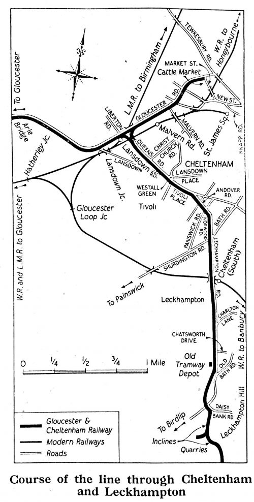
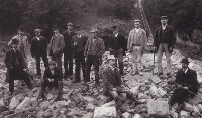
The featured image at the head of this article appears later in the text as well. It comes from an old article in The Railway Magazine. In the February 1953 edition of the magazine. The article in The Railway Magazine followed the route of the Gloucester and Cheltenham Tramroad from Gloucester to Cheltenham and Leckhampton Hill. [11]
The Gloucester and Cheltenham Tramroad was built, primarily, to transport of coal from Gloucester’s docks to the rapidly developing spa town of Cheltenham and to transport of building stone from quarries on nearby Leckhampton Hill. [1][2]
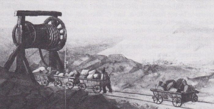
It was ”opened for mineral traffic on 2 July 1810. The line was a 3ft 6 in (1,067mm) gauge plateway, with cast iron plates on stone blocks. Wagons with plain wheels could run on the plates and were guided by an upstand on the plates. The route was single track, but passing places were provided at four to the mile, or more frequently. It appears that more passing places were added later, no doubt in response to higher traffic densities.” [1][2]
A steam locomotive was tried out on the line in 1831 or 1832. The engine was ‘Royal William’, built at Neath Abbey Ironworks. It was an 0-6-0 tender engine. It caused traumatic breakages of the tramplates and for a time the Company thought seriously about converting the line to an edge railway, something which would not have had the approval of traders who used the line at the time. [1]
There is an excellent schematic map of the route of the Tramroad provided in an online publication from the Gloucestershire Society for Industrial Archaeology (GSIA) https://www.gsia.org.uk/gct/gsia-tramroad-history.pdf [10]
Very little of the tramroad remains visible today. The urban areas of Cheltenham and Gloucester have grown closer together over the years and the roads linking them have been widened and realigned. What does remain in the 21st Century? …. We will discover this as we follow the route of the tramroad below and in a second article!
The Route of the Tramroad – starting from the Quarries at Leckhampton Hill
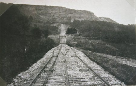
Careful inspection of the 6″ OS Maps published around the turn of the 20th Century shows the old 3ft 6in [17] tramway still in place close to Leckhampton Quarries. The extent of the network was, by this time, drastically curtailed from that which existed in the heyday of the tramroad in the early to mid-1800s. The map extract below shows the tramroad terminating at the Stables and Depot close to the Sanatorium on Leckhampton Road. [12]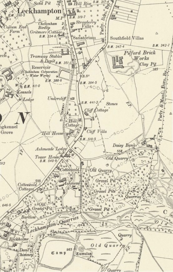 Two passing loops can be seen, one close to Hill Cottage and the other close to Cotteswold (to the north of Ashmead). The southern terminus of the line was high above the main Leckhampton Quarries at Brownstine Quarry just at the southern edge of the map extract above. The black line on the satellite image below shows the approximate line of the tramroad.
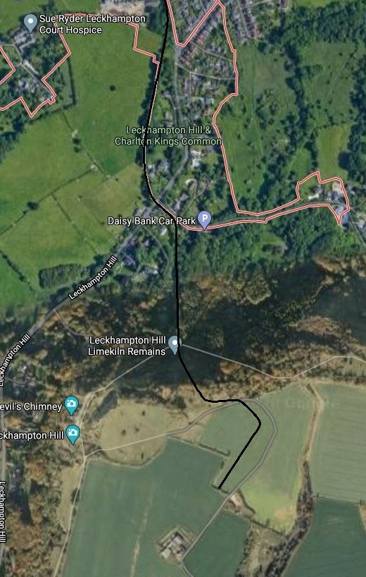 From the location of the old Sanatorium and the Tramroad Depot the line headed North along Leckhampton Road. We will return to that length of the line once we have a better idea of the various tramways and workings around Leckhampton Hill. Key locations on the modern satellite image are marked by flags.
The focal point of the network of tramways on the hills was close to the Limekiln remains flagged above. The sketch map below illustrates this. It shows what remained in around 1925. The majority of these tramways were narrow gauge (3ft 6in [17: p38]). As was the mainline of the tramway from Cheltenham to Gloucester with its branch up to Leckhampton Hill. The sketch map also sows a newer standard-gauge line it was planned would link to exchange sidings and to the line from Cheltenham to Banbury. Only around a mile and a quarter of the work on this line was completed. That did, however, include a significant incline with a bridge under Daisybank Road. 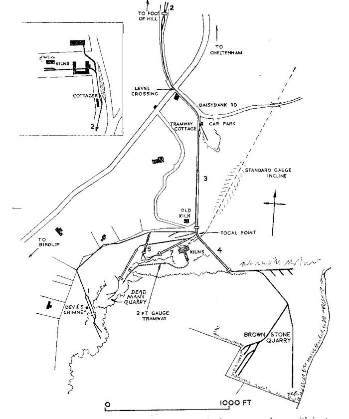 This illustration comes from ‘Old Leckhampton’ by David Bick. The locations marked with numbers are: 1. Devil’s Chimney; 2. Bottom Incline; 3. Middle Incline; 4. Top Incline; 5. No name; 6. Dead Man’s Incline; 7. No name. [13][17]
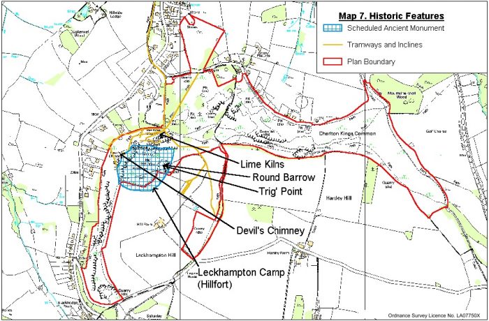
Cheltenham Borough Council Map of Historic Features at Leckhampton Hill. This map was published in 2003. The tramway routes shown in yellow and are quite hard to make out on the map. [18]

This sketch map was carried in the February 1953 edition of The Railway Magazine and shows the tramway running from the quarries in the bottom right of the map. [11: p120]
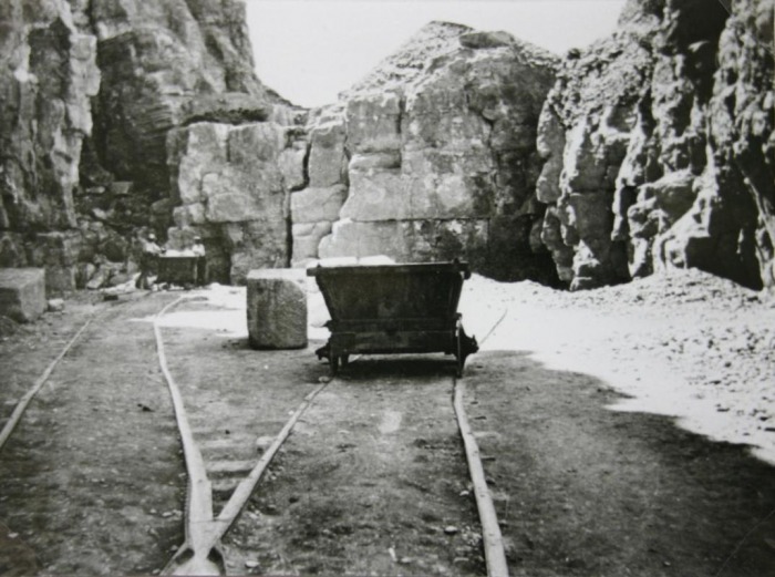
Most quarrying took place on the North and West faces of the hill and the visible areas of rock face which remain in the 21st Century are there as a result of the quarrying work. This is even true of the well-known Devil’s Chimney on the West face of the hill. One quarry, Brownstone, was on the top of the hill remote from the escarpment.
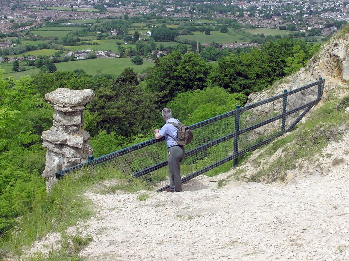
Devil’s Chimney and the view from the top of the Leckhampton Escarpment, (c) Adrian Pingstone, 4th June 2006 – Public Domain. There was a quarry incline between the present view point and the Devil’s Chimney. [15]
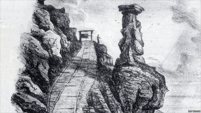
Engraving of the Devil’s Chimney Incline. [16]
The Middle Incline, which starts by Tramway Cottage, is shown in a photograph on the website of the Friends of Leckhampton Hill and Charlton Kings Commom as it was in 2016. [14] The Friends of Leckhampton Hill and Charlton KIngs Common have also provided a shot of the incline at work in 1902 – taken when Tramaway Cottage was demolished as part of riots that year.
Middle Incline is shown at the right-rear of this photograph of the demolished Tramway Cottage in 1902. [14]
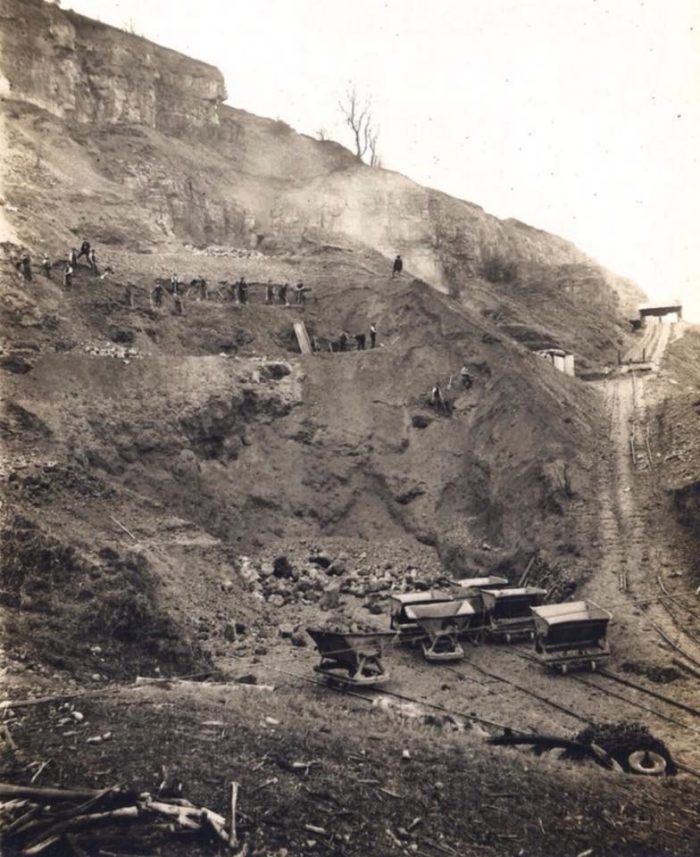
 By September 1924 the limekilns and one and a quarter miles of railway track including the long incline had been completed. However, the project was not a success and all production stopped about two years later and the plant [was] sold in August 1927.” [17]
The Standard-gauge incline (see the adjacent picture, [14[23] connected with further standard gauge tracks (on which was run a small steam engine) which ran eastwards towards the Cheltenham to Banbury line at Charlton Kings. Hisoric England records the line as follows: “A 20th century mineral railway is visible as earthworks on aerial photographs. The railway connected the lime kilns at Leckhampton quarries to the Banbury and Cheltenham Direct Line, near Charlton Kings station. The railway was a standard gauge railway, constructed in 1924 to connect the works on the hill with the depot at Southfield Manor Farm and then the main railway line to the northeast. The railway was subsequently disused by 1927.”[17][19]
The standard-gauge line postdated the Cheltenham to Gloucester Tramroad and its branch to the quarries. David Elder says that little is known of this “ill-fated scheme, begun in 1922, to produce lime on the hill and transport it to Charlton Kings by a specially built standard-gauge railway. Today, the concrete foundations of four large steel limekilns are the main visible reminders of this project, which only lasted five years. The scheme was funded by a government loan to ease unemployment after the First World War.” [5]
Construction of the limekilns was completed by September 1924. “Standing 23.5 metres high it was hoped that, once the kilns had been fired up using producer gas made from coal, they could make 300 tons per day. However, this level was never attained and the resulting lime was not of sufficiently good quality to make the enterprise worthwhile. The standard-gauge railway, connecting the kilns to a depot at Southfield Farm in Charlton Kings and thence to join the railway line at Charlton Kings, employed a three-rail system with a halfway passing point below an overbridge … [at] Daisybank Road. … In the end, although an impressive engineering feat, it produced little of real benefit.” [5]
Jock Leonard published a short piece about the standard-gauge line and its locomotives in a blog in 2015. [6] That drew my attention to a Facebook group called ‘Days Gone by in Cheltenham’. In that group, a search for ‘Leckhampton Quarries’ produced some great pictures of the old tramways and the limekilns on the site. Some of those photographs are included below along with others from different sources on the internet and in literature. All are fully referenced at the bottom of this article.
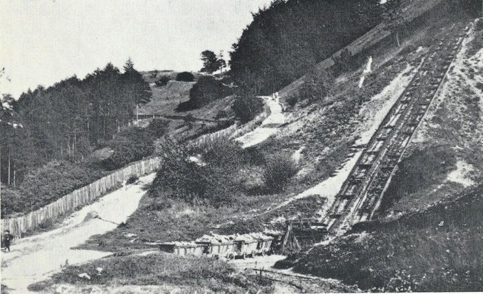
Bottom Incline:
The bottom of Bottom Incline. it was at this point that the public tramroad gave way to the quarry tramroads. Interetsingly, Bick gives the date of this photograph as being around 1895. This is evidence that a length of the tramway alongside Leckhampton Road was retained in use after the closure of Gloucester & Cheltenham Tramroad as a whole, in 1861. Bick says: “Here the Leckhampton branch of the Gloucester and Cheltenham Tramroad met C. B. Trye’s quarry lines. c. 1895. (c) A. T. Bendall.” Leckhampton Road/Hill can be seen on the left of the picture. [9: p32a][21]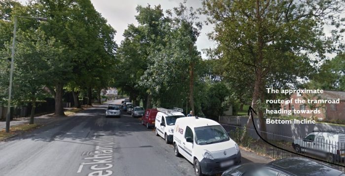 The point where the tramway from Bottom Incline drew alongside Leckhampton Road, as it is in the 21st century. (Google Streetview).
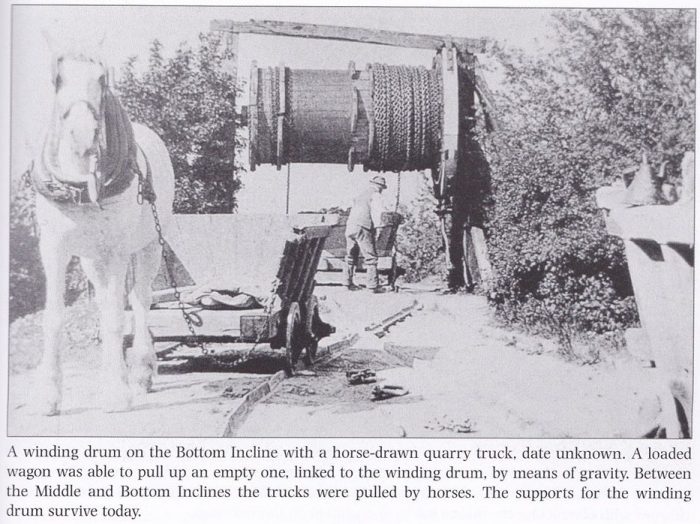 The top of Bottom Incline showing the winding gear most clearly. [8]
The line crossed Leckhampton Road/Hill at grade at the junction with Daisy Bank Road.
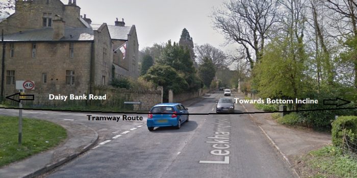
The Tramroad and road crossing location in the 21st century (Google Streetviw).
Middle Incline:
At the bottom of the Middle Incline. The tramway curved round to Daisy Bank Road which is behind the camera, (c) B. Baxter. [11: p121]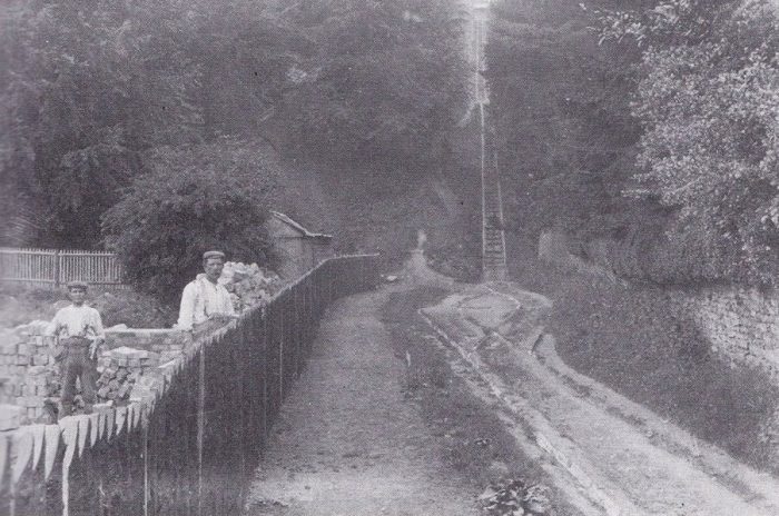 Middle Incline [8]
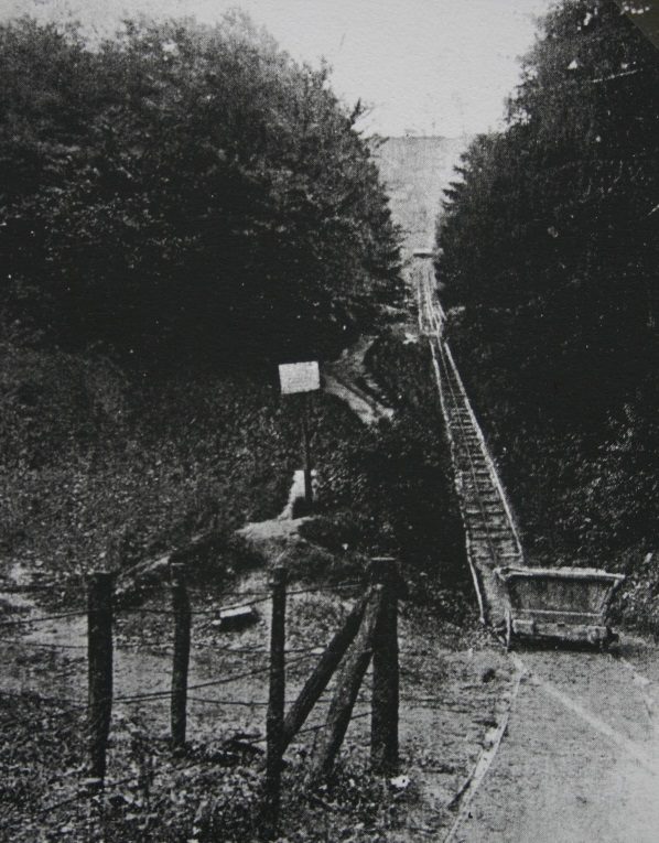 Middle Incline. [21][23]
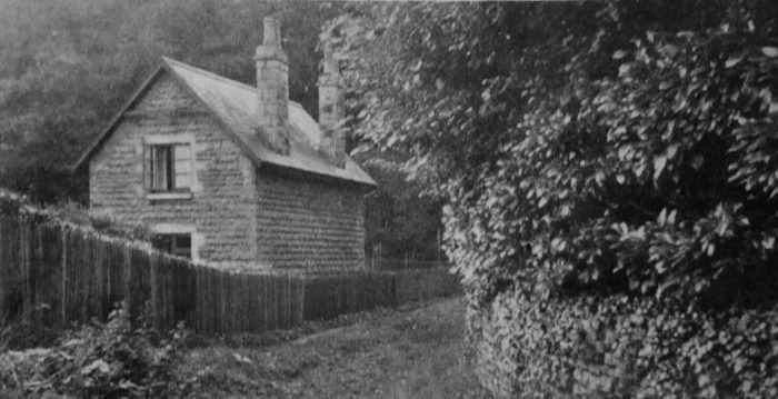
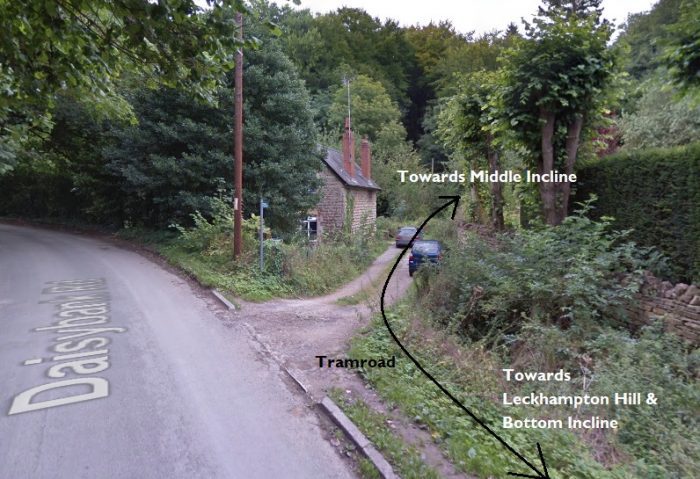 Tramway cottage in the 21st Century (Google Streetview).
I believe that this is an etching of the winding gear at the Devil’s Chimney Incline. If this is the case, then the chimney is just out of the picture to the right. [8]
Before we look at the pictures of the limekilns below, there is an interesting aside which is worth noting, that is that there was a 2 ft Narrow Gauge Railway which conveyed the limestone needed by the kilns. It was “a 2ft gauge “Jubilee track” railway which ran on a ledge which can be traced in part today. At the far end the trucks were pushed across a bridge which connected the cliff face to the kilns and the stone was then tipped from the trucks into the kilns. The change in level along the route may have required a small incline to have been built but it is not clear where this was.” [25: p41]
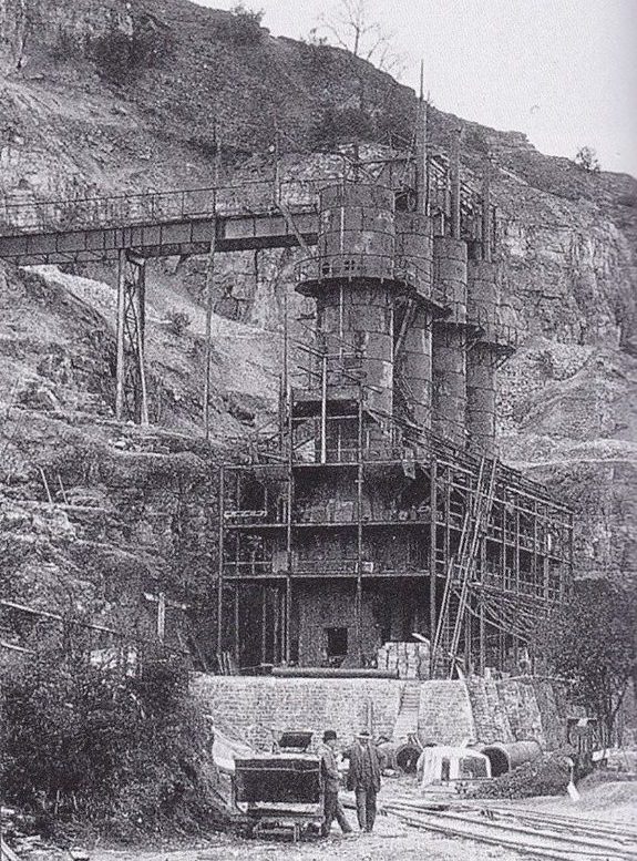
The Limekilns built between 1923 and 1924 – I believe that his is the same location as the image of quarrying above from Gordon Braithwaite [7]. This is another image sourced by Albert Hands. [8]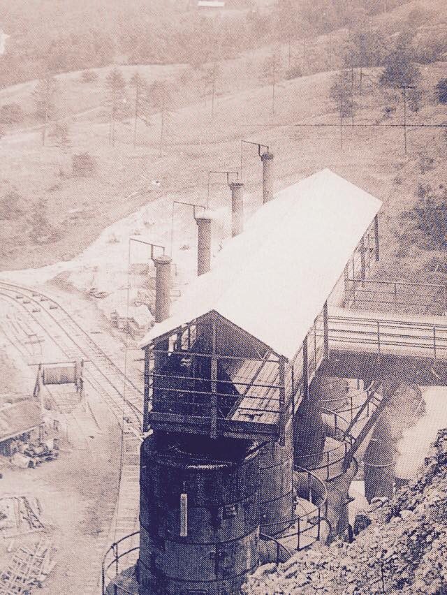 The view from above the Limekilns constructed in the 1920s provides and excellent view of both the top of the Middle Incline, for which the winding drum can be seen, and the standard-gauge incline which superseded it, to its right. [21] A wider version of the same image can be found in David Bick’s booklet which shws that the work to build the standard-gauge incline destroyed the higher parts of the Middle Incline, leaving just the short stub visible in the picture here. [9: p32e]
The focal point of the tramway system with Top Incline heading away to the upper right of the picture (c) T.F. Coke. The line heading towards the camera was at this time the access to some short sidings but in the past had been the tramway route round to the incline at the Devll’s Chimney.. [9: p32c][21]
Dead Man’s Quarry was a lter addition to the excavations at the Leckhampton site it was not until 1905, according to Bick [9] that this quarry needed a tramroad and a new incline.
Dead Man’s Quarry 1911, (c) H.G.W. Household [9: p32c][23].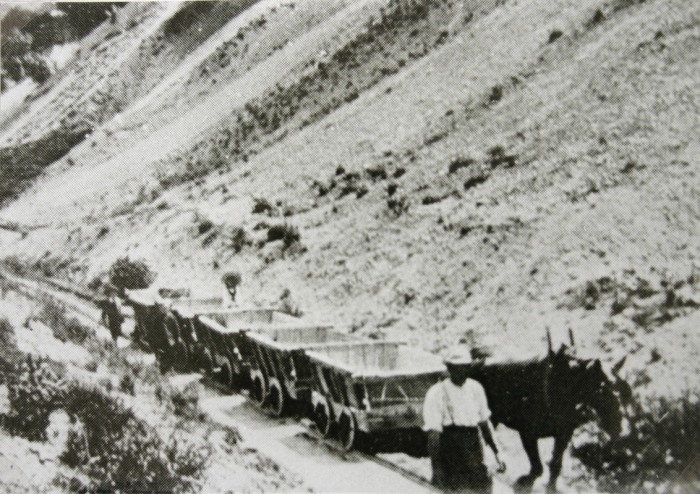 Horse-drawn empty tram ‘train’ returning to Dead Man’s Quarry, Leckhampton in June 1911, (c) H.G.W. Household. [9: p32b][23]
The Linekilns and the Standard-gauge incline are in a very real sense just a footnote to the story of the Cheltenham & Gloucester Tramroad. They appeared late and lasted nothing but a few years!
This first photo shows a Great North of Scotland Railway wagon half-way up the rope incline. It seems unlikely that it was just visiting. Had it been bought or leased by the quarry company – we will never know!

Great North of Scotland on the Standard-Gauge Incline at Leckhampton. [24]
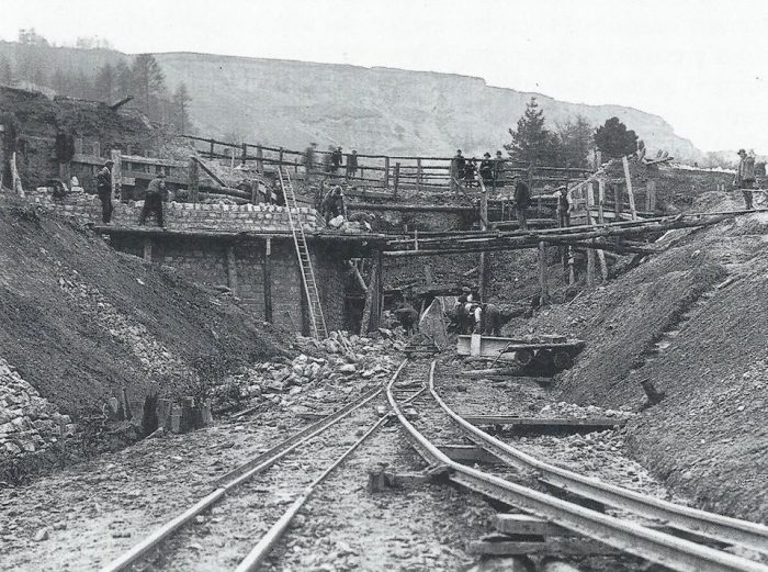
The standard gauge incline and Daisy Bank Bridge under construction. [21]
The Friends of Leckhampton Hill and Charlton Kings Common and the GSIA (Gloucestershire Society for industrial Archaeology) arranged with Cheltenham Borough Council and LifeChart for a display to be placed at the Limekilns site (shown below) which aids visitors in interpreting what they encounter. [14][20]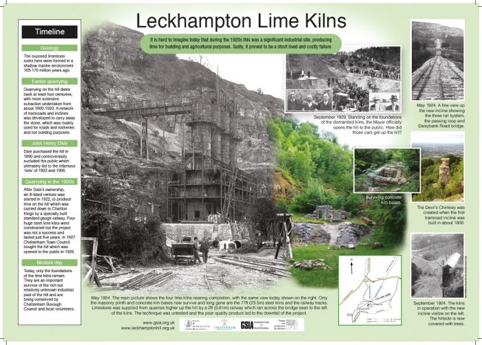 The GSIA & Friends of Leckhampton Hill and Charlton Kings Common display board at Leckhampton Quarries and Limekilns. [14]
The OS map extract below shows that by the time of the publication of the OS 1:25,000 series (1937-1961) very little of the old tramway remained, just a short length behind the old Tramway Depot.
Returning to the line of the old tramroad/tramway branch from Leckhampton Hill into Cheltenham. The quarry tramway lines were served by a Depot alongside Leckhampton Road. The Depot was built in about 1810. it was the location of the Leckhampton Industrial Estate (although I think it has now been developed for housing). In 1923 the depot was transferred to Southfield Farm. [25: p41]
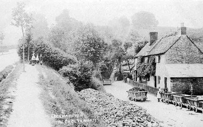
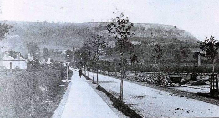
North of the Depot, the old tramroad ran along the west verge of Leckhampton Road towards Cheltenham. When we see images, particularly in the next article in this series, of a tramway in the centre of Leckhampton Road, we need to remember that the tramway in those images is a later tramway which operated in the early 20th Century and which was primarily a passenger tramway. The image below comes from the year 1900, the trees in the verge have just been planted, there is no evidence of a tramway in the centre of the road and the old tramway rails are still evident to the west of the road, on the right of this picture.
 Leckhampton Road under reconstruction. The old tramroad rails appear still to be available at this time as the tramroad wagon on the right of the image testifies. Although some sources do suggest that the rails were lifted when the old tramway closed in 1861, [27][9: p50][23] Bick is clear that the length at this location survived into the 1890s. He says that Trye who owned the quarries in 1861, “retained about 500 yds. of line down the side of Leckhampton Road to a point opposite the Malvern Inn, where he established a stone wharf. This bit of line, the last of the Gloucester and Cheltenham Tramroad, was not taken up until the late 1890s.” [9: p51 (and very briefly on p29)]
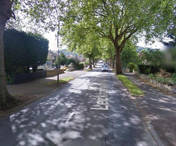 Leckhampton Road in the 21st Century at approximately the same location as the image above (Google Streetview).
References
- https://en.wikipedia.org/wiki/Gloucester_and_Cheltenham_Tramroad, accessed on 18th April 2020.
-
David Verey, Alan Brooks; Gloucestershire 2: The Vale and the Forest of Dean;Yale University Press, 2002, p99
- https://www.gloucestershirelive.co.uk/news/gloucester-news/gallery/remnants-gloucesters-industrial-revolution-littered-3221228,, accessed on 18th April 2020.
- https://www.geograph.org.uk/photo/70782, accessed on 18th April 2020.
- David Elder; Secret Cheltenham; Amberley Publications Ltd, Stroud, Gloucestershire, 2009; accessed via https://books.google.co.uk/books?id=IZOSDwAAQBAJ&pg=PT25&lpg=PT25&dq=standard+gauge+railway+-+Leckhampton+hill&source=bl&ots=AlpLRjl9CA&sig=ACfU3U2VfASkKY18B8xFWUB4y7WiNsgVVQ&hl=en&sa=X&ved=2ahUKEwjm3au7rfzoAhW1Q0EAHVfRAIIQ6AEwB3oECAoQAQ#v=onepage&q=standard%20gauge%20railway%20-%20Leckhampton%20hill&f=false, accessed on 22nd April 2020.
- https://jockleonard.wordpress.com/2015/01/17/standard-gauge-steam-locomotives-working-at-the-leckhampton-quarry, accessed on 22nd April 2020.
- https://www.facebook.com/gordon.braithwaite.1?fref=gh&hc_location=group&__tn__=%2CdC-R-R&dti=243104989178394, accessed on 22nd April 2020.
- Albert Hands who posted these images on the facebook group “Days Gone by in Cheltenham” has sadly passed away and his permission cannot be sought for their inclusion here, neither can their provenance be checked; https://www.facebook.com/groups/243104989178394, accessed on 22nd April 2020.
- D.E. Bick; ‘The Gloucester & Cheltenham Railway and the Leckhampton Quarry Tramroads’; The Oakwood Press, 1968.
- https://www.gsia.org.uk/gct/gsia-tramroad-history.pdf, accessed on 18th April 2020.
- B. Baxter; The Route of the Gloucester & Cheltenham Railway; The Railway Magazine, February 1953: p117-121 & p133. NB: Mike Farmer has noted a small error in the drafting of the map: “The road labelled ‘Liberton Road’ on the map [p120] just by Landsown Railway Station is mis-named: it should be ‘Libertus Road’.” (please see the comments on this post below). This map is the featured image for this article.
- https://maps.nls.uk/geo/explore/#zoom=17&lat=51.86676&lon=-2.07397&layers=6&b=1, accessed on 19th April 2020.
- D.E. Bick; ‘Old Leckhampton (Its Quarries, Railways, Riots and the Devil’s Chimney)’; 2nd Edition, Runpast Publishing, Cheltenham, 1994; noted in reference [14] below.
- https://www.leckhamptonhill.org.uk/site-description/industrial-archaeology/#/ accessed on 20th April 2020.
- https://en.wikipedia.org/wiki/Devil%27s_Chimney_(Gloucestershire)#/media/File:Devils.chimney.viewpoint.at.leckhampton.arp.jpg, accessed on 21st April 2020.
- https://www.google.co.uk/imgres?imgurl=https%3A%2F%2Fnews.bbcimg.co.uk%2Fmedia%2Fimages%2F53100000%2Fjpg%2F_53100654_gsia_4_june_docks_leck_hill.jpg&imgrefurl=https%3A%2F%2Fwww.bbc.co.uk%2Fnews%2Fuk-england-gloucestershire-13617786&tbnid=77PCeAPdUap-vM&vet=12ahUKEwjtl7yKifnoAhV8gM4BHQZqD8EQMygVegQIARAm..i&docid=0rTDiH0XyNGl-M&w=976&h=549&q=Incline%20Devil%27s%20Chimney%20Gloucestershire&client=opera&ved=2ahUKEwjtl7yKifnoAhV8gM4BHQZqD8EQMygVegQIARAm, accessed on 21st April 2020.
- Ray Wilson; The Industrial Archaeology of Leckhampton Hill; in the Gloucestershire Society for Industrial Archeaology Journal, 2001, p38-46, https://gsia.org.uk/leckia.pdf, accessed on 21st April 2020.
- Leckhampton Hill and Charlton Kings Common Management Plan – Issue No. 2 , April 2003; Cheltenham Borough Council; https://www.google.co.uk/url?sa=t&rct=j&q=&esrc=s&source=web&cd=5&ved=2ahUKEwj7_KjynPzoAhUhmVwKHV1nAIAQFjAEegQIBhAB&url=https%3A%2F%2Fwww.cheltenham.gov.uk%2Fdownload%2Fdownloads%2Fid%2F830%2Fleckhampton_hill_and_charlton_kings_common.pdf&usg=AOvVaw0VNsgqsbUK894hVhn2DDh0, accessed on 22nd April 2020.
- https://www.pastscape.org.uk/hob.aspx?hob_id=1509734, accessed on 22nd April 2020.
- https://lifechart.co.uk/services/heritage-trails/leckhampton-hill, accessed on 22nd April 2020.
- https://www.facebook.com/photo.php?fbid=2403959226287834&set=gm.1156616937827190&type=3&theater&ifg=1, posted on the ‘Days Gone by in Cheltenham’ website by Bridget Capon on 18th November 2018, accessed on 22nd April 2020.
- https://leckhamptonlhs.weebly.com/uploads/5/8/8/7/5887234/bulletin_no_1_pdf(1).pdf, accessed on 23rd April 2020.
- http://www.cheltenhamsouthtown.org/tramroad.html, accessed on 23rd April 2020.
- https://www.rmweb.co.uk/community/index.php?/topic/114180-standard-gauge-light-railways-goods-stock/page/2, accessed on 23rd April 2020.
- https://www.gsia.org.uk/reprints/2001/gi200135.pdf, accessed on 23rd April 2020.
- https://jockleonard.wordpress.com/2015/01/17/standard-gauge-steam-locomotives-working-at-the-leckhampton-quarry-circa-1920, accessed on 21st April 2020.
- https://www.facebook.com/photo.php?fbid=10153275218432453&set=gm.465134820308742&type=3&theater&ifg=1, posted on the ‘Days Gone By in Cheltenham’ website by Nik Thomas on 14th May 2015, accessed on 23rd April 2020.
Appendix 1 – THE INDUSTRIAL ARCHAEOLOGY OF LECKHAMPTON HILL – Ray Wilson – Extract from the Gloucestershire Society for Industrial Archaeology Journal for 2001 pp. 35-46
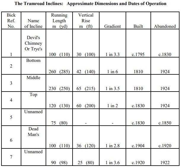
TRAMROAD INCLINES – Table 1 (p43)

#/media/File:Devils.chimney.viewpoint.at.leckhampton.arp.jpg)
When I was about eight -1957 -I can remember the turn at the Queens rd down past the Big midland pub and the Lamp in that roundabout – there was a rail of metal that was protruding above the tarmacadam -my father commented that this was the old tram line ? it was taken up -also there was an underground toilet on the corner of Leckhampton rd (where the horse trough is )and above this toilet (now filled in )there were two rail tracks about twelve feet long (perhaps not the original rail ) that mirrored the actual position of the track -Builders were working with a tracked digger scuffing this up -I rang up a woman who was in charge of the town archaeology and told her about this -They were removed -The owner of the old Crooks laundry in croft street told me that they were the original rail -he may still have some info-hope this helps –
Thank you, Colin.
The metal rails above the toilets in Leckhampton Road, near the Norwood Arms, were part of the framework holding glass panels that let light into the toilets. There used to be two sets, one for the gents, the other for the ladies. It is (was) very tempting to think that they were a hangover from the tramroad, but:
a. They were less than 2 feet apart, whereas the gauge of the tramroad was 3ft 6in
b. The Norwood rails were of a different style from the tramroad ones, which were of much heavier cast iron and each length measured only about one yard
c. The original tramrails in this part of Leckhampton Road were taken up in 1861: it is improbable that just two pairs would have been left there.
Sorry to have put a damper on this widespread myth – it would been so nice if it had been true. I only wish I could have been there when the metal was removed recently, to photograph the metal.
Hi Eric. I agree. However, the old Tramroad did run through to Grotten’s Wharf until around the turn of the 39th Century. As you say it was of a 3ft 6in track gauge.
Roger,
Thanks, but I’m interested in what you say about Grottens Wharf, though. David Bick says that “the whole system was ripped up in 1861, except for the portion down to the old GWR bridge in Leckhampton Road”. He goes on to say that it was further shortened soon afterwards. I have a map, dating probably from the 1890s, which shows the line finishing at a wharf opposite the Malvern Inn. Perhaps some sidings remained near the Grottens.
Eric
Hi Eric
Apologies if I have misread things. I will have another look.
Kind regards
Roger
Eric profuse apologies. You are right. My comment about Grotten’s Wharf was wrong. I have checked my blog post and it talks of a wharf opposite the Malwern Inn. I conflated the two wharves.
Best wishes
Roger
Pingback: Gloucester Docks and Railways – Part 1 | Roger Farnworth
The road labelled ‘Liberton Road’ on the map just by Landsown Railway Station is mis-named: it should be ‘Libertus Road’
Thank you Mike
I have added a note in the references at the bottom of the article – Reference [11].
Best wishes
Roger
Neat finds. Clearly you are having fun with these. 🙂
Tewkesbury Road there on the amp … am certain that at least some of the narrowboaters I follow on YouTube have at least mentioned that town.
Is there a heritage railway there too?
Gonna hafta go play in Google.
The Gloucester and Warwickshire Steam Railway is close by: https://www.gwsr.com/
Dear Roger,
<
div>Thank you very much for sending me this. There’s so much info